Walton Park, New York

Last updated
Walton Park, New York
CDP
Orange County New York incorporated and unincorporated areas Walton Park highlighted.svg
Location in Orange County and the state of New York
USA New York location map.svg
Red pog.svg
Walton Park, New York
Location within the state of New York
Coordinates: 41°18′43″N74°13′26″W / 41.31194°N 74.22389°W / 41.31194; -74.22389 Coordinates: 41°18′43″N74°13′26″W / 41.31194°N 74.22389°W / 41.31194; -74.22389
Country United States
State New York
County Orange
Area
[1]
  Total3.44 sq mi (8.90 km2)
  Land3.08 sq mi (7.99 km2)
  Water0.35 sq mi (0.91 km2)
Elevation
843 ft (257 m)
Population
 (2020)
  Total3,907
  Density1,266.45/sq mi (489.06/km2)
Time zone UTC-5 (Eastern (EST))
  Summer (DST) UTC-4 (EDT)
FIPS code 36-78063 [2]
GNIS feature ID0968741 [3]

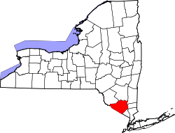
Walton Park is a census-designated place (CDP) in Orange County, New York, United States. As of the 2010 census, the CDP had a total population of 2,669.

Contents

Walton Park is on the town line separating the towns of Chester and Monroe. Street addresses within Walton Park are usually assigned to Monroe, not Chester.

Geography

Walton Park is located at 41°18′43″N74°13′26″W / 41.31194°N 74.22389°W / 41.31194; -74.22389 (41.311849, -74.223838). [4]

According to the United States Census Bureau, the CDP has a total area of 2.7 square miles (7.0 km2), of which 2.4 square miles (6.2 km2) is land and 0.3 square miles (0.78 km2) is water. The total area is 11.57% water.

The community is on the west side of Walton Lake.

Demographics

Historical population
CensusPop.
2020 3,907
U.S. Decennial Census [5]

As of the census [2] of 2000, there were 2,330 people, 776 households, and 637 families residing in the CDP. The population density was 983.0 per square mile (379.6/km2). There were 871 housing units at an average density of 367.5/sq mi (141.9/km2). The racial makeup of the CDP was 94.08% White American, 1.03% African American, 0.90% Native American, 1.29% Asian, 0.17% Pacific Islander, 1.55% from other races, and 0.99% from two or more races. Hispanic or Latino people of any race were 7.04% of the population.

There were 776 households, out of which 45.1% had children under the age of 18 living with them, 72.6% were married couples living together, 6.8% had a female householder with no husband present, and 17.9% were non-families. 14.3% of all households were made up of individuals, and 4.6% had someone living alone who was 65 years of age or older. The average household size was 3.00 and the average family size was 3.35.

In the CDP, the population was spread out, with 30.1% under the age of 18, 5.3% from 18 to 24, 30.7% from 25 to 44, 25.6% from 45 to 64, and 8.3% who were 65 years of age or older. The median age was 37 years. For every 100 females, there were 100 males. For every 100 females age 18 and over, there were 94.6 males.

The median income for a household in the CDP was $70,938, and the median income for a family was $81,139. Males had a median income of $54,375 versus $34,917 for females. The per capita income for the CDP was $28,463. About 2.5% of families and 2.4% of the population were below the poverty line, including 3.0% of those under the age of 18 and none of those 65 and older.

Related Research Articles

<span class="mw-page-title-main">Williamson, Arizona</span> CDP in Yavapai County, Arizona

Williamson is a census-designated place (CDP) in Yavapai County, Arizona, United States. The population was 3,776 at the 2000 census. The name "Wiliamson" is a misnomer, perhaps propagated by federal bureaucratic error; the area has long been known as "Williamson Valley" after the major road through the area, Williamson Valley Road.

<span class="mw-page-title-main">Valinda, California</span> Census-designated place in California, United States

Valinda is a census-designated place (CDP) in the San Gabriel Valley, in Los Angeles County, California, in the United States. At the 2010 census, the population was 22,822, up from 21,776 at the 2000 census.

<span class="mw-page-title-main">Newport Coast, Newport Beach</span> Community of Newport Beach in California, United States

Newport Coast is a community south of the main body of the city of Newport Beach, California. It was a separate census-designated place in Orange County, California, United States, until 2001, when it was annexed into Newport Beach. Newport Beach, California's estimated population is 86,160 according to the most recent United States census estimates. Newport Beach, California is the 96th largest city in California based on official 2017 estimates from the US Census Bureau.

<span class="mw-page-title-main">Loma Rica, California</span> Census-designated place in California, United States

Loma Rica is a census-designated place (CDP) in Yuba County, California, United States. The population was 2,368 at the 2010 census, up from 2,075 at the 2000 census. Loma Rica is located 15 miles (24 km) northeast of Marysville.

<span class="mw-page-title-main">Miramar Beach, Florida</span> Census-designated place in Florida, United States

Miramar Beach is a census-designated place (CDP) in Walton County, Florida, United States. The population was 6,146 at the 2010 census. Although many other coastal localities in Florida have appended "Beach" to their names to distinguish themselves from an adjacent inland or cross-bay municipality – such as Miami Beach, St. Pete Beach, Fort Myers Beach, Panama City Beach, Melbourne Beach, Cocoa Beach, and Jacksonville Beach – the city of Miramar, Florida is actually over 450 miles (720 km) away in South Florida. Miramar Beach is due east of Destin, Florida. It is often considered to be part of the city of Destin. However, it has its own ZIP code (32550) and is in Walton County, whereas Destin is in Okaloosa County.

<span class="mw-page-title-main">Hawaiian Acres, Hawaii</span> Census-designated place in Hawaii, United States

Hawaiian Acres is a census-designated place (CDP) in Hawaiʻi County, Hawaiʻi, United States located in the District of Puna. The population was 2,700 at the 2010 census, up from 1,776 at the 2000 census.

<span class="mw-page-title-main">Makawao, Hawaii</span> Census-designated place in Hawaii, United States

Makawao is a census-designated place (CDP) in Maui County, Hawaiʻi, United States. The population was 7,297 at the 2020 census. Located on the rural northwest slope of Haleakala on East Maui, the community is known for being the hub of the "Upcountry", a part of the island dominated by mostly agriculture and ranch land. Makawao Forest Reserve is to the east-northeast.

<span class="mw-page-title-main">Helena Valley Northeast, Montana</span> Census-designated place in Montana, United States

Helena Valley Northeast is a census-designated place (CDP) in Lewis and Clark County, Montana, United States. The population was 2,995 at the 2010 census. It is part of the Helena Micropolitan Statistical Area.

<span class="mw-page-title-main">Azure, Montana</span> Census-designated place in Montana, United States

Azure is a census-designated place (CDP) in Hill County, Montana, United States. The population was 286 at the 2010 census.

<span class="mw-page-title-main">Firthcliffe, New York</span> CDP in New York, United States

Firthcliffe is a hamlet in Orange County, New York United States. The population was 4,949 at the 2010 census. It is part of the Poughkeepsie–Newburgh–Middletown, NY Metropolitan Statistical Area as well as the larger New York–Newark–Bridgeport, NY-NJ-CT-PA Combined Statistical Area.

<span class="mw-page-title-main">Mechanicstown, New York</span> CDP in New York, United States

Mechanicstown is a hamlet in Orange County, New York, United States. The population was 6,061 at the 2000 census and 6,858 as of the 2010 census. It is part of the Poughkeepsie–Newburgh–Middletown, NY Metropolitan Statistical Area as well as the larger New York–Newark–Bridgeport, NY-NJ-CT-PA Combined Statistical Area.

<span class="mw-page-title-main">Washington Heights, New York</span> CDP in New York, United States

Washington Heights is a census-designated place (CDP) in Orange County, New York, United States. The population was 2,205 at the 2020 census.

<span class="mw-page-title-main">Clintondale, New York</span> CDP in New York, United States

Clintondale is a hamlet in Ulster County, New York, United States. The population was 1,452 at the 2010 census.

<span class="mw-page-title-main">Hillside, New York</span> CDP in New York, United States

Hillside is a census-designated place (CDP) in Ulster County, New York, United States. The population was 877 at the 2010 census.

<span class="mw-page-title-main">Tillson, New York</span> CDP in New York, United States

Tillson is a hamlet in Ulster County, New York, United States. The population was 1,586 at the 2010 census.

<span class="mw-page-title-main">Walker Valley, New York</span> CDP in New York, United States

Walker Valley is a hamlet located in the western part of the Town of Shawangunk in Ulster County, New York, United States, generally thought of as coterminous with the 12588 ZIP code. The population was 853 at the 2010 census.

<span class="mw-page-title-main">Pymatuning South, Pennsylvania</span> Census-designated place in Pennsylvania, United States

Pymatuning South is a census-designated place (CDP) in Crawford County, Pennsylvania, United States. The population was 479 at the 2010 census.

Bressler-Enhaut-Oberlin was a census-designated place (CDP) in Swatara Township, Dauphin County, Pennsylvania, United States. The population was 2,809 at the 2000 census. For the 2010 census it was split into three CDPs, Bressler, Enhaut, and Oberlin. The area is part of the Harrisburg–Carlisle Metropolitan Statistical Area.

<span class="mw-page-title-main">Gardiner (CDP), New York</span> CDP in New York, United States

Gardiner is a hamlet in Ulster County, New York, United States. The population was 950 at the 2010 census.

<span class="mw-page-title-main">Plattekill (CDP), New York</span> CDP in New York, United States

Plattekill is a hamlet in Ulster County, New York, United States. The population was 1,260 at the 2010 census. The community, as is the town, is named after a local stream, the Platte Kill.

References

  1. "ArcGIS REST Services Directory". United States Census Bureau. Retrieved September 20, 2022.
  2. 1 2 "U.S. Census website". United States Census Bureau . Retrieved 2008-01-31.
  3. "US Board on Geographic Names". United States Geological Survey. 2007-10-25. Retrieved 2008-01-31.
  4. "US Gazetteer files: 2010, 2000, and 1990". United States Census Bureau. 2011-02-12. Retrieved 2011-04-23.
  5. "Census of Population and Housing". Census.gov. Retrieved June 4, 2016.