Crawford, New York | |
---|---|
Town of Crawford | |
Coordinates: 41°36′N74°18′W / 41.600°N 74.300°W | |
Country | United States |
State | New York |
County | Orange |
Settled | 1740 |
Established | 1823 |
Government | |
• Type | Town Council |
• Town Supervisor | Charles E. Carnes (REP) |
• Town Council | Members' List |
Area | |
• Total | 40.12 sq mi (103.90 km2) |
• Land | 40.03 sq mi (103.68 km2) |
• Water | 0.08 sq mi (0.22 km2) |
Elevation | 486 ft (148 m) |
Population (2020) | |
• Total | 9,130 |
• Density | 230/sq mi (88/km2) |
Time zone | UTC-5 (EST) |
• Summer (DST) | UTC-4 (EDT) |
FIPS code | 36-18916 |
GNIS feature ID | 0978877 |
Website | Town website |
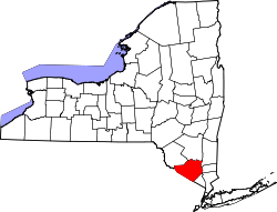
Crawford is a town in the north of Orange County, New York, United States. The population was 9,130 at the 2020 census. [2] The name comes from a settler who gave his name to a community in the hamlet now called Pine Bush.
Crawford was originally settled c. 1740. Crawford was originally part of the Town of Montgomery. Crawford was established as a town in 1823. Ten years earlier, in 1813, it had been branded as the butter capital of the world. Searsville, once an economic center and location of the town government, lost its status when the railroad came to the town through another area.
According to the United States Census Bureau, the town has a total area of 40.2 square miles (104 km2), of which 40.1 square miles (104 km2) is land and 0.04 square miles (0.10 km2) (0.10%) is water.
The northern town line is the border of Ulster County, partly marked by the Shawangunk Kill, a small river.
NYS Route 52 and NYS Route 302 intersect in Pine Bush. NYS Route 17K crosses the southern part of the town.
Census | Pop. | Note | %± |
---|---|---|---|
1830 | 2,019 | — | |
1840 | 2,075 | 2.8% | |
1850 | 1,912 | −7.9% | |
1860 | 2,003 | 4.8% | |
1870 | 2,024 | 1.0% | |
1880 | 1,951 | −3.6% | |
1890 | 1,876 | −3.8% | |
1900 | 1,778 | −5.2% | |
1910 | 1,659 | −6.7% | |
1920 | 1,507 | −9.2% | |
1930 | 1,800 | 19.4% | |
1940 | 1,786 | −0.8% | |
1950 | 2,410 | 34.9% | |
1960 | 2,574 | 6.8% | |
1970 | 3,896 | 51.4% | |
1980 | 4,910 | 26.0% | |
1990 | 6,394 | 30.2% | |
2000 | 7,875 | 23.2% | |
2010 | 9,316 | 18.3% | |
2020 | 9,130 | −2.0% | |
U.S. Decennial Census [3] |
As of the census [4] of 2000, there were 7,875 people, 2,707 households, and 2,133 families residing in the town. The population density was 196.3 inhabitants per square mile (75.8/km2). There were 2,851 housing units at an average density of 71.1 per square mile (27.5/km2). The racial makeup of the town was 95.59% white, 1.19% African American, 0.08% Native American, 0.76% Asian, 0.01% Pacific Islander, 1.16% from other races, and 1.21% from two or more races. Hispanic or Latino of any race were 5.13% of the population.
There were 2,707 households, out of which 42.3% had children under the age of 18 living with them, 65.8% were married couples living together, 8.2% had a female householder with no husband present, and 21.2% were non-families. 17.4% of all households were made up of individuals, and 7.2% had someone living alone who was 65 years of age or older. The average household size was 2.90 and the average family size was 3.29.
In the town, the population was spread out, with 30.3% under the age of 18, 6.1% from 18 to 24, 30.2% from 25 to 44, 24.1% from 45 to 64, and 9.2% who were 65 years of age or older. The median age was 36 years. For every 100 females, there were 98.3 males. For every 100 females age 18 and over, there were 94.2 males.
The median income for a household in the town was $57,063, and the median income for a family was $63,722. Males had a median income of $42,200 versus $30,763 for females. The per capita income for the town was $21,614. About 2.7% of families and 4.0% of the population were below the poverty line, including 3.5% of those under age 18 and 7.0% of those age 65 or over.
Hamden is a town in Delaware County, New York, United States. The population was 1,137 at the 2020 census.
Collins is a town in Erie County, New York, United States. The town is on the south border of the county and is considered to be one of the "Southtowns" of Erie County. The population at the 2010 census was 6,601.
Caroga is a town in Fulton County, New York, United States. The population was 1,205 at the 2010 census. The town was named after a local creek.
Manheim is a town in Herkimer County, New York, United States. The population was 3,334 at the 2010 census. The town name is derived from Mannheim in Baden, Germany.
Clarkson is a town in Monroe County, New York, United States. The population was 6,904 at the 2020 census. The town is named after General Matthew Clarkson.
Glen is a town in Montgomery County, New York, United States. The population was 2,507 at the 2010 census. The town was named after Jacob Glen, an early landowner.
Verona is a town in southwestern Oneida County, New York, United States. The population was 6,293 at the 2010 census. The town was named after Verona, Italy.
Clay is a town in Onondaga County, New York, United States. As of the 2020 Census, the population was 60,527, making it Syracuse's most populous suburb. The town was named after American attorney and statesman Henry Clay.
Spafford is a town in Onondaga County, New York, United States. As of the 2020 Census, the population was 1,588. The town was named after Horatio Gates Spafford, a writer and founder of the local library. Spafford is in the southwestern corner of Onondaga County and is southwest of Syracuse.
Pine Bush is a hamlet located in the town of Crawford and adjacent to Shawangunk, New York, within Orange and adjacent to Ulster counties in the U.S. It is roughly coterminous with the 12566 ZIP code and 744 telephone exchange in the 845 area code. These both extend into adjacent regions of the town of Shawangunk in Ulster County.. The population was 1,751 at the 2020 census.
Wallkill is a town in Orange County, New York, United States. The population was 30,486 at the 2020 census. It is centrally located in the county. Interstate 84 crosses New York State Route 17 in the southern part of the town. U.S. Route 6 and New York State routes 17K, 211 and 302 also cross portions of the town.
Broome is a town in Schoharie County, New York, United States. The population was 863 at the 2020 census. The town is named after John Broome.
Bloomingburg, previously Bloomingburgh, is a village in the Sullivan County town of Mamakating, New York, United States. The population was 1,032 at the 2020 census.
Walker Valley is a hamlet located in the western part of the Town of Shawangunk in Ulster County, New York, United States, generally thought of as coterminous with the 12588 ZIP code. The population was 1,269 at the 2020 census.
Wawarsing is a town in Ulster County, New York, United States. The population was 12,771 at the 2020 census. The name Wawarsing was once believed to mean "a place where the streams wind" in the Lenape language, referring to the geography in the hamlet of Wawarsing. Specifically, the joining of the Ver Nooy Kill and the Rondout Creek at Port Ben. The name Wawarsing was used by the Lenape to designate the current hamlet and the fields to the north and south of it for at least six miles in both directions. It is the only Lenape name known to refer to an exact location in Ulster County.
Walton is a town in Delaware County, New York, United States. The population was 5,270 at the 2020 census. The town is in the west-central part of the county and contains the village of Walton. The town claims to be the "Scarecrow Capital of the World."
Johnstown is a town located in Fulton County, New York, United States. As of the 2010 census, the town had a population of 7,098. The name of the town is from landowner William Johnson. The town of Johnstown is located on the southern border of the county. It borders on three sides the city of Johnstown and the city of Gloversville.
Elba is a town in Genesee County, New York, United States. The population was 2,370 at the 2010 census. The town is at the northern border of the county and is north of the city of Batavia. The town contains the village of Elba, located near the town's center.
Richmondville is a town in Schoharie County, New York, United States. The population was 2,466 at the 2020 census. The town name was adapted from the name of a post office in its territory.
Waterloo is a town in Seneca County, New York, United States. The population was 7,378 at the 2020 census. The town and its major community are named after Waterloo, Belgium, where Napoleon was defeated.