Kowŏn County is a county in South Hamgyŏng province, North Korea. It lies at the southern tip of the province.

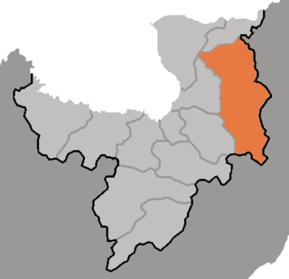
Kosŏng County is a kun, or county, in Kangwŏn province, North Korea. It lies in the southeasternmost corner of North Korea, immediately north of the Korean Demilitarized Zone. Prior to the end of the Korean War in 1953, it made up a single county, together with what is now the South Korean county of the same name. In a subsequent reorganization, the county absorbed the southern portion of Tongch'ŏn county.

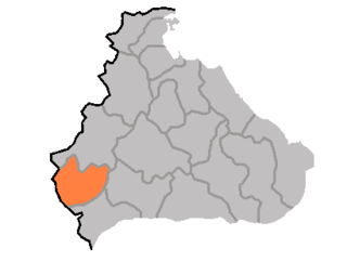
Anbyŏn is a kun, or county, in Kangwŏn province, North Korea. Originally included in South Hamgyŏng province, it was transferred to Kangwŏn province in a September 1946 reshuffling of local government.

Ch'angdo County is a kun, or county, in Kangwŏn province, North Korea. Originally part of Kimhwa, it was split off as a separate county in 1952.

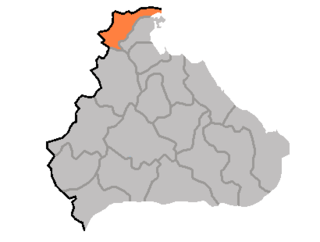
Ch'ŏrwŏn County is a kun, or county, in Kangwŏn province, North Korea. Portions of it were once a single county together with the county of the same name in South Korea; other portions were added from neighbouring counties in the 1952 reorganization of local governments. After the initial division of Korea, the entire county lay to the Northern side of the dividing line, but in the course of the Korean War part of the county was taken by the South.
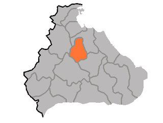
Ch'ŏnnae County is a kun, or county, in Kangwŏn province, North Korea. Originally part of Munch'ŏn, it was made a separate county as part of the general reorganization of local government in December 1952.

Hoeyang County is a kun, or county, in Kangwŏn province, North Korea. It was established in a general reorganization of local government in 1952.
Ich'ŏn County is a kun, or county, in northern Kangwŏn province, North Korea. The terrain is predominantly high and mountainous; the highest point is Myongidoksan, 1,585 meters above sea level. The county's borders run along the Masingryong and Ryongam ranges. The chief stream is the Rimjin River.
Kosan County is a kun, or county, in Kangwŏn province, North Korea.

Kimhwa County is a kun, or county, in Kangwŏn province, North Korea.

Pŏptong County is a kun in the Kangwŏn province, North Korea.
P'an'gyo County is a kun, or county, in Kangwŏn province, North Korea. In December 1952, during the Korean War, P'an'gyo was formed as a separate county from five myŏn of Ichŏn-gun and Yujin-myŏn of P'yŏnggang-gun. Myŏn were administrative units below county (kun) level and are no longer used in North Korea.

Kŭmgang County is a kun, or county, in Kangwŏn province, North Korea. Kŭmgang lies immediately north of the Korean Demilitarized Zone. It was formed in 1952 from a portion of Hoeyang County and from those sections of Yanggu, and Rinje counties that remained under Northern control after the armistice. The county takes its name from the Mount Kŭmgang, which is partially located there. The county seat, Kŭmgang-ŭp, was formerly called Malhwi-ri.

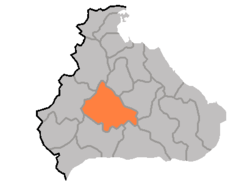
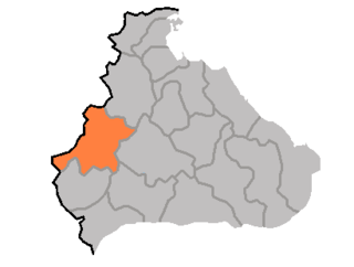
P'yŏnggang County is a kun, or county, in Kangwŏn province, North Korea. It borders Sep'o to the north, Ch'ŏrwŏn to the south, Ich'ŏn to the west, and Kimhwa to the east.
Paegam County is a kun, or county, in Ryanggang province, North Korea.

Unhŭng County is a kun, or county, in Ryanggang Province, North Korea. It was created following the division of Korea from portions of Hyesan and Kapsan.

Kujang County is a kun, or county, in southeastern North P'yŏngan province, North Korea. It was created in 1952 from part of Nyŏngbyŏn county, as part of a nationwide reorganization of local government. It borders Nyŏngbyŏn on the west, Hyangsan and Unsan counties on the north, Nyŏngwŏn on the east, and Kaech'ŏn and Tŏkch'ŏn cities to the south.
P'yŏngsan station is a railway station located in P'yŏngsan-ŭp P'yŏngsan County, North Hwanghae province, North Korea. It serves as the junction point of two railway lines – the P'yŏngbu Line, which connects P'yŏngyang to Kaesŏng, and the Ch'ŏngnyŏn Ich'ŏn Line, which runs from P'yŏngsan to Sep'ŏ where it connects to the Kangwŏn Line.
Sep'o Ch'ŏngnyŏn station is a railway station in Sep'o-ŭp, Sep'o county, Kangwŏn province, North Korea; it is the junction point of the Kangwŏn and Ch'ŏngnyŏn Ich'ŏn lines of the Korean State Railway.

The Kangwŏn Line is a 145.8 km (90.6 mi) electrified standard-gauge trunk line of the Korean State Railway of North Korea, connecting Kowŏn on the P'yŏngra Line to P'yŏnggang, providing an east–west connection between the P'yŏngra and Ch'ŏngnyŏn Ich'ŏn lines.