Sharur-Daralayaz uezd

Last updated
Sharur-Daralayaz uezd
Шаруро-Даралагёзскій уѣздъ
Coat of Arms of Erivan gubernia (Russian empire).png
Sharur-Daralayaz Uyezd of Erivan Governorate.png
Location in the Erivan Governorate
Country Russian Empire
Viceroyalty Caucasus
Governorate Erivan
Established1849
Abolished1929
CapitalBashnorashen
(present-day Sharur)
Area
  Total3,001.64 km2 (1,158.94 sq mi)
Population
 (1916)
  Total90,250
  Density30/km2 (78/sq mi)
   Rural
100.00%

The Sharur-Daralayaz uezd [lower-alpha 1] was a county ( uezd ) of the Erivan Governorate of the Caucasus Viceroyalty of the Russian Empire. [3] It bordered the governorate's Erivan and Nor Bayazet uezds to the north, the Nakhichevan uezd to the south, the Zangezur and Jevanshir uezds of the Elizavetpol Governorate to the east, and Persia to the southwest. It included most of the Vayots Dzor Province of present-day Armenia and the Sharur District of the Nakhchivan exclave of present-day Azerbaijan. The administrative centre of the county was Bashnorashen (present-day Sharur). [4]

Contents

Economy

Armenians were mostly concentrated in mountainous Daralayaz, while lowland Sharur was overwhelmingly Tatar. The population in Daralayaz was engaged primarily in cattlebreeding while the residents of Sharur were engaged in agricultural farming and gardening. Manufacturing was not developed in this part of the governorate. Only 47 winemaking enterprises, 299 mills, 89 cotton-cleaning, 4 rice-cleaning factories existed in the Sharur-Daralayaz uezd. [5]

Geography

The geography of the uezd resembled a crater surrounded from the south, north and east by tall mountain ranges of the Lesser Caucasus. The plain, which made up a small part of the uezd, was close to the Aras River, into which the only river irrigating the plains, the Arpa-chay, discharged. The mountainous part of the territory was called Daralayaz and the lowland part was called Sharur. Daralayaz constituted approximately 70% of the whole uezd area and Sharur constituted approximately 30%, even though it included about half of the uezd's population. The Arpa-chay started at the southeastern tip of Lake Sevan (Gokcha) and flowed 107 versts before discharging into the Aras. It had many tributaries, the Alagyoz-chay being the longest. Approximately 12,150 desyatins of the mountainous part of uezd was forested. The temperature in the winter reached -27 °C. [5]

History

The territory of the uezd was part of Persia's Erivan and Nakhchivan Khanates until 1828, when according to the Treaty of Turkmenchay, they were annexed to the Russian Empire. It was administered as part of the Armenian Oblast from 1828 to 1840. [6] In 1844, the Caucasus Viceroyalty was re-established, in which the territory of the Sharur-Daralayaz uezd formed part of the Tiflis Governorate. In 1849, the Erivan Governorate was established, separate from the Tiflis Governorate. It was made up of the Erivan, Nakhchivan, Alexandropol, Nor Bayazet, and Ordubad uezds. Following administrative reforms, the northern part of the Nakhchivan uezd (Daralayaz) was separated to form part of the new Sharur-Daralayaz uezd in 1870. [7]

Throughout 1918–1920, the uezd was heavily contested between forces of the First Republic of Armenia and Azerbaijan Democratic Republic. [8]

After the establishment of Soviet rule in 1920, the territory of the uezd was divided. Daralayaz (modern-day Vayots Dzor) became part of the Armenian SSR and Sharur became part of the Nakhichevan ASSR of the Azerbaijan SSR in accordance with the treaties of Moscow and Kars. [9]

Administrative divisions

The subcounties ( uchastoks ) of the Sharur-Daralayaz uezd in 1913 were as follows: [10]

Name1912 populationArea
1-y uchastok (1-й участокъ)44,051747.26 square versts (850.43  km2 ; 328.35  sq mi )
2-y uchastok (2-й участокъ)44,4481,890.24 square versts (2,151.21  km2 ; 830.59  sq mi )

Demographics

Russian Empire Census

According to the Russian Empire Census, the Sharur-Daralayaz uezd had a population of 76,538 on 28 January [ O.S. 15 January] 1897, including 41,055 men and 35,483 women. The plurality of the population indicated Tatar [lower-alpha 2] to be their mother tongue, with significant Armenian and Kurdish speaking minorities. [13]

Linguistic composition of the Sharur-Daralayaz uezd in 1897 [13]
LanguageNative speakers%
Tatar [lower-alpha 2] 51,56067.37
Armenian 20,72627.08
Kurdish 3,7614.91
Assyrian 3310.43
Russian 610.08
Ukrainian 570.07
Polish 120.02
Georgian 70.01
Jewish 60.01
Belarusian 40.01
Greek 40.01
German 10.00
Italian 10.00
Other70.01
TOTAL76,538100.00

Kavkazskiy kalendar

According to the 1917 publication of Kavkazskiy kalendar , the Sharur-Daralayaz uezd had a population of 90,250on 14 January [ O.S. 1 January] 1916, including 47,399 men and 42,851 women, 88,496 of whom were the permanent population, and 1,754 were temporary residents. The statistics indicated the uezd to be overwhelmingly Shia Muslim with a significant Armenian minority: [14]

NationalityNumber%
Shia Muslims [lower-alpha 3] 57,98264.25
Armenians 29,16532.32
Kurds 1,8612.06
Asiatic Christians 5980.66
Sunni Muslims [lower-alpha 4] 5110.57
Russians 1220.14
Other Europeans 80.01
North Caucasians 30.00
TOTAL90,250100.00

Settlements

According to the 1897 census, there were 58 settlements in the Sharur-Daralayaz uezd with a population over 500 inhabitants. The religious composition of the settlements was as follows: [16]

NameFaithTOTAL
RussianRomanized Armenian Apostolic Muslim Armenian Catholic MaleFemaleBoth
Аг-АхмедAg-Akhmed (Axaməd)811435376811
Аг-кендAg-kend (Aghnjadzor)670373297670
АзадекAzadek (Azatek)731357394751
Айназур (Агавнадзор)Aynazur (Agavnadzor) (Aghavnadzor)776452399851
АлаклуAlaklu (Ələkli)740395372767
АлишарAlishar (Alışar)1,1255835421,125
Араб-ЕнгиджаArab-Yengija (Ərəbyengicə)652355297652
АргезArgez (abandoned)587323264587
АрпаArpa (Areni)545312267579
АхураAkhura (Axura)537309228537
БашкендBashkend (Vernashen)570317277594
БашнорашенBashnorashen (Sharur)132687504363867
ВармазиарVarmaziar (Vərməziyar)985516469985
Гасан-кендGasan-kend (Shatin)522278245523
ГергерGerger (Herher)5111,0477817811,562
ГиндевазGindevaz (Gndevaz)442163338267605
ГорсGors (Hors)1,1366544821,136
ДжульJul (Artavan)1,2146595551,214
ДудангаDudanga (Düdəngə)922507415922
Енгиджа (Енгиджа-Султан)Yengija (Yengija-Sultan) (Yengicə)2,0341,1509272,077
ЗейваZeyva (Zeyvə)600316284600
КабахлуKabakhly (Goghtanik)566312254566
КазулджаKazulja (abandoned)630357273630
КарагасанлуKaragasanlu (Qarahəsənli)777407372779
КараклухKaraklukh (Karaglukh)786417372789
КархунKarkhun (abandoned)334267601
КешишкендKeshishkend (Yeghegnadzor)1,2956886131,301
КештазKeshtaz (Çəmənli)355323369309678
Кийтул (Котур)Kiytul (Kotur) (Getap)735400371771
Кишляг-АббасKishlyag-Abbas (Qışlaqabbas)666365301666
Кущи (Кущи-Биляк)Kushchi (Kushchi-Bilyak) (Kechut)631326305631
Кущи-ДемурчиKushchi-Demurchi (Dəmirçi)1,8381,0338051,838
КяримбеклуKyarimbeklu (Kərimbəyli)847444403847
КюртчулуKyurtchulu (Kürçülü)610319291610
Малишка Malishka 1,2306736081,281
Мартирос Martiros 1,0225304921,022
Махмуд-кендMakhmud-kend (Mahmudkənd)609344265609
МахтаMakhta (Maxta)1,1866435441,187
МуганлуMuganlu (Muğanlı)608331277608
ОртакендOrtakend (Gladzor)686360343703
ПарчиParchi (absorbed by Xanlıqlar)105406263248511
ПашалуPashalu (Zaritap)682338383721
ПисианPisian (Püsyan)1,3547436111,354
СаллыSally (Salli)668363305668
СараглуSaraglu (abandoned)504269235504
СиягутSiyagut (Siyaqut)388281374333707
Тазакенд (Сардарабат)Tazakend (Sardarabat) (Təzəkənd)627349278627
Улия НорашенUliya Norashen (Oğlanqala)1,2286605941,254
ХаладжKhalaj (Xələc)598303295598
ХанлухлярKhanlukhlyar (Xanlıqlar)1,0235994911,090
Хачик Khachik 968515453968
ЧарчибоганCharchibogan (Çərçiboğan)933487446933
Чива Chiva 689355334689
ЧомахтурChomakhtur (Çomaxtur)1,0185304881,018
ШагриарShagriar (Şəhriyar)1,2276695581,227
ЭльпинElpin (Yelpin)708356352708
ЭрдапинErdapin (Artabuynk)530278252530
ЯйджиYayji (Yuxarı Yaycı)1,8469728741,846
TOTAL17,93831,10328126,98923,49650,485

Notes

    • Russian: Шару́ро-Даралагёзскій уѣ́здъ, romanized: Sharúro-Daralagyózsky uyézd
    • Armenian: Շարուր-Դարալագյազի գավառ, romanized: Šarowr-Daralagyazi gavaṙ
    • Azerbaijani: شرور و درلاگس قضاسی, romanized: Şarūr-ü Daralāges qaz̤āsı, [1] or شرور و دارالاگز قضاسی, Şarūr-ü Dārālāgez qaz̤āsı [2]
  1. 1 2 Before 1918, Azerbaijanis were generally known as "Tatars". This term, employed by the Russians, referred to Turkic-speaking Muslims of the South Caucasus. After 1918, with the establishment of the Azerbaijan Democratic Republic and "especially during the Soviet era", the Tatar group identified itself as "Azerbaijani". [11] [12]
  2. Primarily Tatars. [15]
  3. Primarily Turco-Tatars. [15]

Related Research Articles

Kazakh <i>uezd</i> Uezd in Caucasus, Russian Empire

The Kazakh uezd was a county (uezd) of the Elizavetpol Governorate of the Russian Empire and later of the Azerbaijan Democratic Republic with its center in Kazakh from 1868 until its formal abolition in 1929 by the Soviet authorities of the Azerbaijan SSR. The area of the Kazakh uezd forms a large part of the modern-day Tavush Province and a small northeastern part of the Gegharkunik Province of Armenia, also forming most of the area of the Agstafa, Tovuz and Qazax districts of Azerbaijan.

Nukha <i>uezd</i> Uezd in Caucasus, Russian Empire

The Nukha uezd was a county (uezd) of the Elizavetpol Governorate of the Russian Empire and later of the Azerbaijan Democratic Republic with its center in Nukha from 1868 until its formal abolition in 1921 by the Soviet authorities of the Azerbaijan SSR.

Elizavetpol <i>uezd</i> Uezd in Caucasus, Russian Empire

The Elizavetpol uezd, also known as the Ganja uezd after 1918, was a county (uezd) of the Elizavetpol Governorate of the Russian Empire, and later of the Azerbaijan Democratic Republic and Azerbaijan SSR until its formal abolition in 1929. The area of the Elizavetpol uezd corresponds to the modern-day Gadabay, Shamkir, Dashkasan, Goygol, and Samukh districts of Azerbaijan.

Erivan <i>uezd</i> County of the Russian Empire

The Erivan uezd was a county (uezd) of the Erivan Governorate of the Caucasus Viceroyalty of the Russian Empire. The uezd bordered the Etchmiadzin and Surmalu uezds to the west, the Nor Bayazet uezd to the east, the Sharur-Daralayaz uezd to the south, and Iran to the southwest. It included most of the Ararat Province and southern parts of the Kotayk Province of central Armenia, the Sadarak District of the Nakhchivan exclave of Azerbaijan, and the Aras corridor of the Aralık District of the Iğdır Province of Turkey. The administrative centre of the county was the city of Erivan.

Nakhichevan <i>uezd</i> Uezd in Caucasus, Russian Empire

Surmalu <i>uezd</i> Uezd in Caucasus, Russian Empire

The Surmalu uezd was a county (uezd) of the Erivan Governorate of the Caucasus Viceroyalty of the Russian Empire. It bordered the governorate's Etchmiadzin and Erivan uezds to the north, the Kars Oblast to the west, Persia to the east, and the Ottoman Empire to the south. The district made up most of the Iğdır Province of present-day Turkey. As part of the Russian Transcaucasus, the Surmalu uezd possessed economical importance for its abundantly rich salt mines in Kulp (Tuzluca), and spiritual importance to Armenians as the location of the culturally significant Mount Ararat. The administrative centre of the county was Igdyr.

Nor Bayazet <i>uezd</i> Uezd in Caucasus, Russian Empire

The Nor Bayazet or Novobayazet uezd was a county (uezd) of the Erivan Governorate of the Caucasus Viceroyalty of the Russian Empire. The uezd bordered the Alexandropol uezd to the north, the Etchmiadzin and Erivan uezds to the west, the Sharur-Daralayaz uezd to the south, and the Kazakh, Elizavetpol, and Jevanshir uezds of the Elizavetpol Governorate to the east. Centered on Lake Sevan, the Nor Bayazet uezd included most of the contemporary province of Gegharkunik and northern parts of the Kotayk Province of Armenia. The administrative center of the uezd was the city Novobayazet for which the district was eponymously named.

Etchmiadzin <i>uezd</i> Uezd in Caucasus, Russian Empire

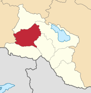
The Etchmiadzin uezd was a county (uezd) of the Erivan Governorate of the Caucasus Viceroyalty of the Russian Empire. The uezd bordered the Alexandropol uezd to the north, the Nor Bayazet uezd to the east, Erivan uezd to the north, the Surmalu uezd to the south, and the Kars Oblast to the west. It included all of the Armavir Province and most of the Aragatsotn Province of present-day Armenia. The administrative centre of the county was Vagorshapat (Vagharshapat), also referred to as Etchmiadzin—the administrative capital of the Armenian Apostolic Church.

Ozurgeti <i>uezd</i> Uezd in Caucasus, Russian Empire

The Ozurgeti uezd was a county (uezd) of the Kutaisi Governorate of the Caucasus Viceroyalty of the Russian Empire. It bordered the Senaki uezd to the north, the Kutaisi uezd to the east, the Akhaltsikhe uezd of the Tiflis Governorate to the southeast, the Batum Okrug of the Batum Oblast to the south, and the Black Sea to the west. The area of the Ozurgeti uezd corresponded to most of the contemporary Guria region of Georgia. The county was eponymously named for its administrative center, Ozurgeti.

Javad <i>uezd</i> Uezd in Caucasus, Russian Empire

The Javad uezd, known after 1921 as the Salyan uezd, was a county (uezd) within the Baku Governorate of the Russian Empire and then of the Azerbaijan Democratic Republic and Azerbaijan SSR until its formal abolishment in 1929 by the Soviet authorities. The uezd was located in the central part of the governorate, bordering the Geokchay, Shemakha, and Baku uezds to the north, Caspian sea to the east, Lenkoran uezd to the south and Iran to the west. The administrative center of the uezd was the city of Salyan.

Zugdidi <i>uezd</i> Uezd in Caucasus, Russian Empire

The Zugdidi uezd was a county (uezd) of the Kutaisi Governorate of the Caucasus Viceroyalty of the Russian Empire. It bordered the Sukhumi Okrug to the north, the Lechkhumi uezd to the east, the Senaki uezd to the south, and the Black Sea to the west. The area of the Zugdidi uezd corresponded to most of the contemporary Samegrelo-Zemo Svaneti region of Georgia. The county was eponymously named for its administrative center, Zugdidi.

Shemakha <i>uezd</i> Uezd in Caucasus, Russian Empire

The Shemakha uezd was a county (uezd) within the Baku Governorate of the Russian Empire, and then of Azerbaijan Democratic Republic and Azerbaijan SSR until its formal abolishment in 1929. The county was located in central part of the Baku Governorate, bordering the Javad uezd to the south, Baku uezd to the east, Geokchay uezd to the west and Kuba uezd to the north. The administrative centre of the county was the city of Shemakha.

Geokchay <i>uezd</i> Uezd in Caucasus, Russian Empire

The Geokchay uezd was a county (uezd) of the Baku Governorate of the Russian Empire and then of the Azerbaijan Democratic Republic and Azerbaijan SSR until its formal abolishment in 1929. The uezd was located in the central part of the governorate, bordering the Kuba uezd to the north, the Shemakha uezd to the east, the Javad uezd to the south and the Elizavetpol Governorate to the west. The administrative center of the uezd was the city of Geokchay.

Akhalkalaki <i>uezd</i> Uezd in Caucasus, Russian Empire

The Akhalkalaki uezd was a county (uezd) of the Tiflis Governorate of the Caucasus Viceroyalty of the Russian Empire, and then of Democratic Republic of Georgia, with its administrative centre in Akhalkalak. The county bordered the Gori uezd to the north, the Borchaly uezd to the east, the Alexandropol uezd of the Erivan Governorate and the Kars and Ardahan okrugs of the Kars Oblast to the south, and the Akhaltsikhe uezd to the west. The area of the county roughly corresponded to the contemporary Samtskhe–Javakheti region of Georgia.

Signakh <i>uezd</i> Uezd in Caucasus, Russian Empire

The Signakh uezd was a county (uezd) of the Tiflis Governorate of the Caucasus Viceroyalty of the Russian Empire, and then of Democratic Republic of Georgia, with its administrative centre in Signakh. The area of the county roughly corresponded to the contemporary Kakheti region of Georgia.

Tiflis <i>uezd</i> Uezd in Caucasus, Russian Empire

The Tiflis uezd was a county (uezd) of the Tiflis Governorate of the Caucasus Viceroyalty of the Russian Empire, and then of Democratic Republic of Georgia, with its administrative centre in Tiflis. The area of the uezd roughly corresponded to the contemporary Kvemo Kartli region of Georgia. The district bordered the Telavi uezd to the northeast, the Tionety and Dusheti uezds to the north, the Gori uezd to the northwest, the Borchaly uezd to the west, the Kazakh uezd of the Elizavetpol Governorate to the south, and the Signakh uezd to the east.

Kutaisi <i>uezd</i> Uezd in Caucasus, Russian Empire

The Kutaisi uezd was a county (uezd) of the Kutaisi Governorate of the Caucasus Viceroyalty of the Russian Empire. It bordered the Akhaltsikhe uezd of the Tiflis Governorate to the south, the Ozurgeti and Senaki uezds to the west, the Lechkhumi and Racha uezds to the north, and the Shorapani uezd to the east. The area of the uezd corresponded to most of the contemporary Imereti region of Georgia. The Kutaisi uezd was eponymously named for its administrative center, Kutais.

Lechkhumi <i>uezd</i> Uezd in Caucasus, Russian Empire

The Lechkhumi uezd was a county (uezd) of the Kutaisi Governorate of the Caucasus Viceroyalty of the Russian Empire. It bordered the Terek and Kuban oblasts to the north, the Sukhumi Okrug to the west, the Zugdidi, Senaki, and Kutais uezds to the south and the Racha uezd to the east. The area of the uezd corresponded to most of the contemporary Samegrelo-Zemo Svaneti region of Georgia. The administrative center of the Lechkhumi uezd was the town of Tsageri.

Senaki <i>uezd</i> Uezd in Caucasus, Russian Empire

The Senaki uezd was a county (uezd) of the Kutaisi Governorate of the Caucasus Viceroyalty of the Russian Empire. It bordered the Zugdidi uezd to the west, the Lechkhumi uezd to the north, the Kutaisi uezd to the east, and the Ozurgeti uezd to the south. The area of the uezd corresponded to most of the contemporary Samegrelo-Zemo Svaneti region of Georgia. The Senaki uezd was eponymously named for its administrative center, Senaki.

Shorapani <i>uezd</i> Uezd in Caucasus, Russian Empire

The Shorapani uezd was a county (uezd) of the Kutaisi Governorate of the Caucasus Viceroyalty of the Russian Empire. It bordered the Racha uezd to the north, the Kutaisi uezd to the west, and the Tiflis Governorate to the east. The area of the uezd corresponded to most of the contemporary Imereti region of Georgia. The administrative center of the Shorapani uezd was Kvirila.

References

  1. Кавказский календарь на 1855 годъ [Caucasian calendar for 1855] (in Russian, Armenian, Greek, and Azerbaijani). Tiflis: Office of the Caucasian Viceroy. 1854. p. 376 via Google books.
  2. Sâmî, Şemseddîn (1889). قاموس الاعلام: تاریخ و جغرافیا لغاتنی و تعبیر اصحله كافه اسماء خاصه‌یی جامعدر (in Ottoman Turkish). Mihran Matbaası. pp. 840–841 via Google Books.
  3. "НЭБ - Национальная электронная библиотека". rusneb.ru - Национальная электронная библиотека. Retrieved 2022-08-03.
  4. Tsutsiev 2014, p. 59.
  5. 1 2 Большой энциклопедический словарь Брокгауза и Ефрона. Шаруро-Даралагезский уезд [Brockhaus and Efron Encyclopedia Dictionary. Sharur-Daralagyoz Uyezd] (in Russian).
  6. Bournoutian, George A. (1992). The Khanate of Erevan Under Qajar Rule, 1795-1828. Costa Mesa: Mazda Publishers. p. 26. ISBN   9780939214181.
  7. "Административно-территориальные реформы на Кавказе в середине и во второй половине XIX века" [Administrative-territorial reforms in the Caucasus in the middle and second half of the 19th century] (in Russian).
  8. Tsutsiev 2014, pp. 71–76.
  9. Tsutsiev 2014.
  10. Кавказский календарь на 1913 год, pp. 172–179.
  11. Bournoutian 2018, p. 35 (note 25).
  12. Tsutsiev 2014, p. 50.
  13. 1 2 "Демоскоп Weekly - Приложение. Справочник статистических показателей". www.demoscope.ru. Retrieved 2022-03-26.
  14. Кавказский календарь на 1917 год, pp. 214–221.
  15. 1 2 Hovannisian 1971, p. 67.
  16. Troinitsky, N. A. (1905). Населенные места Российской империи в 500 и более жителей с указанием всего наличного в них населения и числа жителей преобладающих вероисповеданий, по данным первой всеобщей переписи населения 1897 г. [Populated areas of the Russian Empire with 500 or more inhabitants, indicating the total population in them and the number of inhabitants of the predominant religions, according to the first general population census of 1897] (in Russian). Saint Petersburg: Tipografiya Obshchestvennaya polza. pp. 52–56. Archived from the original on 10 August 2022.

Bibliography

39°32′45″N44°58′20″E / 39.54583°N 44.97222°E / 39.54583; 44.97222