Shippingport, Pennsylvania

Last updated

Shippingport, Pennsylvania
Shippingport cooling towers from south.jpg
Beaver County Pennsylvania incorporated and unincorporated areas Shippingport highlighted.svg
Location in Beaver County and the U.S. state of Pennsylvania.
Coordinates: 40°37′28″N80°25′29″W / 40.62444°N 80.42472°W / 40.62444; -80.42472
Country United States
State Pennsylvania
County Beaver
Incorporated1910
Government
  TypeBorough Council
Area
[1]
  Total3.68 sq mi (9.54 km2)
  Land3.33 sq mi (8.62 km2)
  Water0.36 sq mi (0.92 km2)
Elevation
741 ft (226 m)
Population
 (2020) [2]
  Total160
  Estimate 
(2021) [2]
157
  Density56.81/sq mi (21.93/km2)
Time zone UTC-5 (Eastern (EST))
  Summer (DST) UTC-4 (EDT)
Zip code
15077
Area code 724
FIPS code42-70376
Website shippingportpa.com

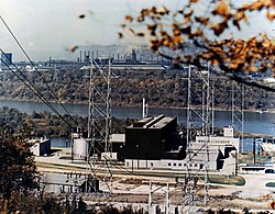
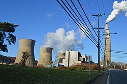
Shippingport is a borough in western Beaver County, Pennsylvania, United States, located along the Ohio River. The population was 160 at the 2020 census. [2] It is part of the Pittsburgh metropolitan area. Shippingport is home to the Beaver Valley Nuclear Power Station, and formerly the Bruce Mansfield Power Plant and Shippingport Atomic Power Station, the world's first full-scale atomic electric power plant devoted exclusively to peacetime uses. [3]

Contents

Nuclear energy

Shippingport Reactor in 1957. Shippingport Reactor.jpg
Shippingport Reactor in 1957.

Shippingport is the site of the United States' first commercial nuclear power plant, the Shippingport Atomic Power Station, which began operation in 1957. [4] Although the original Shippingport reactor was decommissioned in 1982, [5] the Beaver Valley Nuclear Power Station Units 1 and 2 from the same site have been in operation since 1976 and 1987, respectively.

Geography

Shippingport is located in west-central Beaver County at 40°37′25″N80°25′29″W / 40.62361°N 80.42472°W / 40.62361; -80.42472 (40.623594, −80.424691), [6] on the south side of the Ohio River. It is bordered to the southwest by Greene Township and to the southeast by Raccoon Township. To the north, across the Ohio River, are the boroughs of Industry (north) and Midland (northwest). The Shippingport Bridge carries Pennsylvania Route 168 across the river into Industry.

According to the United States Census Bureau, Shippingport has a total area of 3.7 square miles (9.5 km2), of which 3.3 square miles (8.6 km2) is land and 0.35 square miles (0.9 km2), or 9.65%, is water. [7]

Demographics

Historical population
CensusPop.Note
1920 299
1930 3176.0%
1940 44139.1%
1950 408−7.5%
1960 383−6.1%
1970 328−14.4%
1980 255−22.3%
1990 227−11.0%
2000 2374.4%
2010 214−9.7%
2020 160−25.2%
2021 (est.)157 [2] −1.9%
Sources: [8] [9] [10]

As of the 2000 census, [9] there were 237 people, 89 households, and 63 families residing in the borough. The population density was 72.2 inhabitants per square mile (27.9/km2). There were 95 housing units at an average density of 29.0 per square mile (11.2/km2). The racial makeup of the borough was 100.00% White.

There were 89 households, out of which 32.6% had children under the age of 18 living with them, 55.1% were married couples living together, 13.5% had a female householder with no husband present, and 29.2% were non-families. 25.8% of all households were made up of individuals, and 11.2% had someone living alone who was 65 years of age or older. The average household size was 2.66 and the average family size was 3.21.

In the borough the population was spread out, with 27.8% under the age of 18, 8.0% from 18 to 24, 28.3% from 25 to 44, 19.8% from 45 to 64, and 16.0% who were 65 years of age or older. The median age was 33 years. For every 100 females, there were 89.6 males. For every 100 females age 18 and over, there were 96.6 males.

The median income for a household in the borough was $33,333, and the median income for a family was $34,861. Males had a median income of $27,159 versus $15,938 for females. The per capita income for the borough was $13,759. About 7.0% of families and 7.5% of the population were below the poverty line, including 16.7% of those under the age of eighteen and none of those sixty five or over.

Education

Children in Shippingport are served by the South Side Area School District. The current schools serving Shippingport are:

See also

Related Research Articles

<span class="mw-page-title-main">Ben Avon, Pennsylvania</span> Borough in Pennsylvania, United States

Ben Avon is a borough in Allegheny County, Pennsylvania, United States, along the Ohio River. The population was 1,918 at the 2020 census. It is part of the Pittsburgh metropolitan area.

<span class="mw-page-title-main">Leetsdale, Pennsylvania</span> Borough in Allegheny county, Pennsylvania

Leetsdale is a borough in Allegheny County, Pennsylvania, along the Ohio River. It is part of the Pittsburgh Metro Area. The population was 1,162 at the 2020 census.

<span class="mw-page-title-main">Baden, Pennsylvania</span> Borough in Pennsylvania, United States

Baden is a borough in southeastern Beaver County, Pennsylvania, along the Ohio River. The population was 3,904 at the 2020 census. It is part of the Pittsburgh metropolitan area. Baden is the former site of Logstown, a significant Native American settlement.

<span class="mw-page-title-main">Big Beaver, Pennsylvania</span> Borough in Pennsylvania, United States

Big Beaver is a borough in northern Beaver County, Pennsylvania, United States. The population was 1,852 at the 2020 census. It is a part of the Pittsburgh metropolitan area. The area was originally incorporated as Big Beaver Township in 1802, and was reincorporated as a borough in 1958.

<span class="mw-page-title-main">Bridgewater, Pennsylvania</span> Borough in Pennsylvania, United States

Bridgewater is a borough in central Beaver County, Pennsylvania, United States, at the confluence of the Beaver and Ohio rivers. The population was 745 at the 2020 census. It is part of the Pittsburgh metropolitan area. The borough is best known as the home of the Bruster's Ice Cream chain. A few scenes in the 1986 movie Gung Ho were also shot in Bridgewater. Much of Bridgewater, including its two major streets, are included in the Bridgewater Historic District.

<span class="mw-page-title-main">Conway, Pennsylvania</span> Borough in Pennsylvania, United States

Conway is a borough in Beaver County, Pennsylvania, United States, located along the Ohio River. At the 2020 census, the borough had a total population of 2,168. It is part of the Pittsburgh metropolitan area. Conway is the site of the Conway Yard, a major railroad classification yard and locomotive facility owned by the Norfolk Southern Railway. From 1956 until 1980, it was the largest rail yard in the world.

<span class="mw-page-title-main">East Rochester, Pennsylvania</span> Borough in Pennsylvania, United States

East Rochester is a borough in central Beaver County, Pennsylvania, along the Ohio River. The population was 565 at the 2020 census. It is part of the Pittsburgh metropolitan area.

<span class="mw-page-title-main">Eastvale, Pennsylvania</span> Borough in Pennsylvania, United States

Eastvale is a borough in Beaver County, Pennsylvania, United States, along the Beaver River. The population was 183 at the 2020 census. It is part of the Pittsburgh metropolitan area.

<span class="mw-page-title-main">Fallston, Pennsylvania</span> Borough in Pennsylvania, United States

Fallston is a borough in Beaver County, Pennsylvania, United States, along the Beaver River. The population was 259 at the 2020 census. It is a part of the Pittsburgh metropolitan area.

<span class="mw-page-title-main">Freedom, Pennsylvania</span> Borough in Pennsylvania, United States

Freedom is a borough in Beaver County, Pennsylvania, United States, located along the Ohio River 25 miles (40 km) northwest of Pittsburgh. The population was 1,496 at the 2020 census. It is part of the Pittsburgh metropolitan area. Originally founded as a steamboat building town, chief industries later included the production of oil, caskets, and monuments.

<span class="mw-page-title-main">Georgetown, Beaver County, Pennsylvania</span> Borough in Pennsylvania, United States

Georgetown is a borough in western Beaver County, Pennsylvania, United States, along the Ohio River. The population was 208 at the 2020 census. It is part of the Pittsburgh metropolitan area. Little Blue Run Lake, the U.S.'s largest coal slurry waste impound, is located next to the town.

<span class="mw-page-title-main">Glasgow, Pennsylvania</span> Borough in Pennsylvania, United States

Glasgow is a borough in Beaver County, Pennsylvania, United States, along the Ohio River. The population was 71 at the 2020 census.

<span class="mw-page-title-main">Greene Township, Beaver County, Pennsylvania</span> Township in Pennsylvania, United States

Greene Township is a township in Beaver County, Pennsylvania, United States. The population was 2,194 at the 2020 census. It is part of the Pittsburgh metropolitan area.

<span class="mw-page-title-main">Hookstown, Pennsylvania</span> Borough in Pennsylvania, United States

Hookstown is a borough in western Beaver County, Pennsylvania, United States. The population was 129 at the time of the 2020 census. It is part of the Pittsburgh metropolitan area.

<span class="mw-page-title-main">Industry, Pennsylvania</span> Borough in Pennsylvania, United States

Industry is a borough in western Beaver County, Pennsylvania, United States, along the Ohio River. As of the 2020 census, the population was 1,838. It is part of the Pittsburgh metropolitan area.

<span class="mw-page-title-main">Koppel, Pennsylvania</span> Borough in Pennsylvania, United States

Koppel is a borough in northern Beaver County, Pennsylvania, United States. The population was 712 at the 2020 census. It is part of the Pittsburgh metropolitan area.

<span class="mw-page-title-main">Midland, Pennsylvania</span> Borough in Pennsylvania, United States

Midland is a borough located along the Ohio River in western Beaver County, Pennsylvania, United States. As of the 2020 census, the population was 2,433. It is part of the Pittsburgh metropolitan area. Founded in 1906, it was initially a company town surrounding the Crucible Steel Company's Midland Works.

<span class="mw-page-title-main">Ohioville, Pennsylvania</span> Borough in Pennsylvania, United States

Ohioville is a borough in western Beaver County, Pennsylvania, United States. The population was 3,349 at the 2020 census. It is part of the Pittsburgh metropolitan area.

<span class="mw-page-title-main">South Heights, Pennsylvania</span> Borough in Pennsylvania, United States

South Heights is a borough in Beaver County, Pennsylvania, United States, along the Ohio River. The population was 384 at the 2020 census. South Heights was first known as Ethel's Landing, a docking point on the Ohio River. The name of the town was changed to Shannopin when the Pittsburgh and Lake Erie Railroad established a station there. When the name of the town was changed to South Heights, the station became known as South Heights station.

<span class="mw-page-title-main">South Shenango Township, Pennsylvania</span> Township in Pennsylvania, United States

South Shenango Township is a township in Crawford County, Pennsylvania, United States. The population was 1,831 at the 2020 census, down from 2,037 at the 2010 census.

References

  1. "2019 U.S. Gazetteer Files". United States Census Bureau. Retrieved July 28, 2020.
  2. 1 2 3 4 Bureau, US Census. "City and Town Population Totals: 2020-2021". Census.gov. US Census Bureau. Retrieved July 19, 2022.
  3. "History". Nuclear Regulatory Commission (NRC). April 17, 2007. Retrieved July 8, 2016.
  4. "History". Nuclear Regulatory Commission (NRC). April 17, 2007. Retrieved June 6, 2009.
  5. "Shippingport". Archived from the original on November 13, 2005. Retrieved June 24, 2006.
  6. "US Gazetteer files: 2010, 2000, and 1990". United States Census Bureau. February 12, 2011. Retrieved April 23, 2011.
  7. "Geographic Identifiers: 2010 Demographic Profile Data (G001): Shippingport borough, Beaver County, Pennsylvania". U.S. Census Bureau, American Factfinder. Archived from the original on February 12, 2020. Retrieved February 26, 2014.
  8. "Census of Population and Housing". U.S. Census Bureau. Retrieved December 11, 2013.
  9. 1 2 "U.S. Census website". United States Census Bureau . Retrieved January 31, 2008.
  10. "Incorporated Places and Minor Civil Divisions Datasets: Subcounty Resident Population Estimates: April 1, 2010 to July 1, 2012". Population Estimates. U.S. Census Bureau. Archived from the original on June 11, 2013. Retrieved December 11, 2013.