Sinaloan dry forests | |
---|---|
Ecology | |
Realm | Neotropical |
Biome | tropical and subtropical dry broadleaf forests |
Borders | |
Geography | |
Area | 77,201 km2 (29,807 sq mi) |
Country | Mexico |
States | |
Conservation | |
Conservation status | Critical/endangered [1] |
Global 200 | Mexican dry forests |
Protected | 7,815 km² (10%) [2] |
The Sinaloan dry forests is a tropical dry broadleaf forest ecoregion in western Mexico. It is the northernmost ecoregion of the Neotropical realm.
The ecoregion covers an area of approximately 29,900 sq mi (77,000 km2) [3]
The dry forests lie in the coastal plain and foothills between the Pacific Ocean and the pine-oak forests of the Sierra Madre Occidental, covering most of Sinaloa and Nayarit states and extending into portions of adjacent Sonora, Chihuahua, and Jalisco states.
To the north, the Sonoran–Sinaloan transition subtropical dry forest is a transition between the Sinaloan dry forests and the Sonoran Desert. On the south, the dry forests transition to the coastal Jalisco dry forests southwest of the Río Grande de Santiago, and the interior Bajío dry forests to the southeast.
A number of rivers cross the ecoregion from origins in the Sierra Madre Occidental to empty into the Pacific. These include, from north to south, the Fuerte, Sinaloa, Culiacán, San Lorenzo, Elota, Piaxtla, Presidio, Baluarte, Acaponeta, San Pedro Mezquital, and Grande de Santiago rivers. In the mountains the dry forests extend into the river canyons, and in the lowlands the rivers support riparian forests. Extensive lagoon and estuary systems along the coast are home to wetlands and mangroves.
The climate is semi-arid to semi-humid, generally drier near the coast and becoming more humid in the foothills. [4] Rainfall is highly seasonal, with an October to June dry season.
Plant communities include thorn forests in the coastal lowlands, and dry deciduous forests in foothills of the Sierra Madre Occidental. [4]
Thorn forests are characterized by dense growth of scrubby trees and shrubs. Spiny leguminous trees, particularly Acacia , are predominant. [4] High stands of trees, including species of Brosimum, Ficus, and Enterolobium , are found along stream bottoms. [4]
The predominant plant community of the foothills is short-statured, seasonally deciduous forest. Common plants include Handroanthus impetiginosus , tree morning-glory ( Ipomoea arborescens ), cuajilote ( Pseudobombax palmeri ), Bursera laxiflora , and Conzattia sericia , along with species of Montanoa, Bursera, Acacia, Cassia , and Lysiloma . In the mountain canyons higher up are taller-statured forests, with Ceiba acuminata, Bursera simaruba, Lysiloma divaricatum , and Psidium sartorianum as the dominant trees, covered in abundant lianas and epiphytes. [4]
Large mammals include white-tailed deer (Odocoileus virginianus), javelina (Tayassu tajacu), jaguar (Panthera onca), coyote (Canis latrans), ocelot (Leopardus pardalis pardalis), jaguarundi (Herpailurus yagouaroundi), gray fox (Urocyon cinereoargenteus nigrirostris), raccoon (Procyon lotor mexicanus), and white-nosed coati (Nasua narica molaris). [5]
Native birds characteristic of the dry forests include the rufous-bellied chachalaca (Ortalis wagleri), Orange-fronted parakeet (Aratinga canicularis), Citreoline trogon (Trogon citreolus), russet-crowned motmot (Momotus mexicanus), streak-backed oriole (Icterus pustulatus), Mexican cacique (Cacicus melanicterus), thick-billed kingbird (Tyrannus crassirostris), Sinaloa wren (Thryothorus sinaloae), Mexican woodnymph (Eupherusa ridgwayi), Mexican parrotlet (Forpus cyanopygius), Sinaloa crow (Corvus sinaloae), San Blas jay (Cyanocorax sanblasianus), purplish-backed jay (Cyanocorax beecheii), black-throated magpie-jay (Calocitta colliei), rufous-backed thrush (Turdus rufopalliatus), and elegant quail (Callipepla douglasii). [6] [7]
Native reptiles include the Rio Fuerte beaded lizard (Heloderma exasperatum), clouded anole (Anolis nebulosus), Sinaloan milk snake (Lampropeltis triangulum sinaloae), filetail ground snake (Sonora aemula), indigo snake or babatuco (Drymarchon corais), Mexican short-tailed snake (Sympholis lippiens), blunthead tree snake (Imantodes gemmistratus), Mexican moccasin, pichecuate or cantíl (Agkistrodon bilineatus), and Mexican west coast rattlesnake (Crotalus basiliscus). [8]
Native amphibians include Smith's pygmy robber frog (Craugastor hobartsmithi).
11% of the ecoregion is in protected areas. Protected areas include Cascada de Basaseachi National Park, Sierra de Álamos–Río Cuchujaqui Flora and Fauna Protection Area, Meseta de Cacaxtla Flora and Fauna Protection Area, and Tutuaca Flora and Fauna Protection Area. There are several designated Ramsar sites (wetlands of international importance) in the ecoregion, including Marismas Nacionales and the Ceuta Lagoon system. [9]
Nayarit, officially the Estado Libre y Soberano de Nayarit, is one of the 31 states that, along with Mexico City, comprise the Federal Entities of Mexico. It is divided in 20 municipalities and its capital city is Tepic.
The Sonoran Desert is a hot desert in North America and ecoregion that covers the northwestern Mexican states of Sonora, Baja California, and Baja California Sur, as well as part of the southwestern United States. It is the hottest desert in both Mexico and the United States. It has an area of 260,000 square kilometers (100,000 sq mi).
The Sierra Madre Occidental is a major mountain range system of the North American Cordillera, that runs northwest–southeast through northwestern and western Mexico, and along the Gulf of California. The Sierra Madre is part of the American Cordillera, a chain of mountain ranges (cordillera) that consist of an almost continuous sequence that form the western "sounds" of North America, Central America, South America, and West Antarctica.
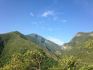
The Sierra Madre Oriental is a mountain range in northeastern Mexico. The Sierra Madre Oriental is part of the American Cordillera, a chain of mountain ranges (cordillera) that consists of an almost continuous sequence of mountain ranges that form the western "backbone" of North America, Central America, South America, and Antarctica.
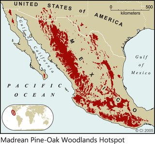
The Madrean pine–oak woodlands are subtropical woodlands found in the mountains of Mexico and the southwestern United States. They are a biogeographic region of the tropical and subtropical coniferous forests and temperate broadleaf and mixed forests biomes, located in North America.
The Sierra Madre Occidental pine–oak forests are a Temperate broadleaf and mixed forests ecoregion of the Sierra Madre Occidental range from the southwest USA region to the western part of Mexico. They are home to a large number of endemic plants and important habitat for wildlife.
The narrow-skulled pocket mouse is a species of rodent in the family Heteromyidae. It is endemic to western Mexico, living west of the Sierra Madre Occidental crest.
The Veracruz moist forests is a tropical moist broadleaf forests ecoregion in eastern Mexico.
Mexican dry forest describes a number of ecoregions of Mexico within the dry broadleaf forest Biome. Together they constitute a World Wildlife Fund Global 200 priority ecoregions area for conservation.
The Balsas dry forests is a tropical dry broadleaf forest ecoregion located in western and central Mexico.
The Central Mexican matorral is an ecoregion of the deserts and xeric shrublands biome of central Mexico. It is the southernmost ecoregion of the Nearctic realm.
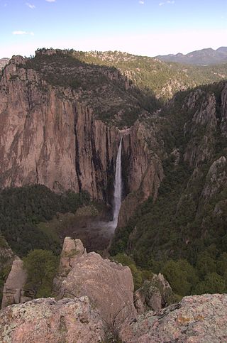
Basaseachic Falls National Park is a national park located in the western side of the state of Chihuahua in the heart of the Sierra Madre Occidental mountain range. The park is named after Basaseachic Falls the second tallest waterfall in Mexico with a height of 246 meters (853 ft). Basaseachic Falls empties into Candameña Canyon which was carved by the Basaseachic River over millions of years. The park is known for its pine-oak forest, rock formations, and scenic views from high cliffs. Cliffs in the park reach an impressive height of 1,640 meters (5,380 ft).
The Sonoran–Sinaloan transition subtropical dry forest is a tropical dry broadleaf forest ecoregion in northwestern Mexico.
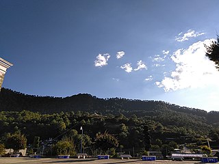
The Sierra Madre del Sur pine–oak forests is a subtropical coniferous forest ecoregion in the Sierra Madre del Sur mountain range of southern Mexico.
The Chiapas Depression dry forests form one of the ecoregions that belong to the tropical and subtropical dry broadleaf forests biome, as defined by the World Wildlife Fund, in northwestern Central America.
The Jalisco dry forests is a tropical dry broadleaf forest ecoregion in southwestern Mexico.
The Southern Pacific dry forests is a tropical dry broadleaf forest ecoregion in southern Mexico.
The Sierra de Álamos–Río Cuchujaqui Flora and Fauna Protection Area, also known as the Sierra de Álamos–Río Cuchujaqui Biosphere Reserve, is a protected area and biosphere reserve in western Mexico. It is located in southeastern Sonora state, along the boundary with Sinaloa and Chihuahua states.
The Sierra de San Juan Biosphere Reserve is a protected area in Nayarit state of western Mexico. It was established in 2003, and has an area of 198.01 km2. It lies just southwest of the city of Tepic. It protects a portion of the Sierra de San Juan, a mountain range which lies between Tepic and the Pacific Ocean.
The Espinazo del Diablo is a region of the Sierra Madre Occidental in the states of Sinaloa and Durango in northwestern Mexico. The region is known its natural beauty and biodiversity, including rare cloud forests, and for a stretch tortuous mountain highway also called the Espinazo del Diablo.