
Lilium is a genus of herbaceous flowering plants growing from bulbs, all with large prominent flowers. They are the true lilies. Lilies are a group of flowering plants which are important in culture and literature in much of the world. Most species are native to the northern hemisphere and their range is temperate climates and extends into the subtropics. Many other plants have "lily" in their common names, but do not belong to the same genus and are therefore not true lilies.

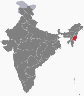
Manipur is a state in Northeast India, with the city of Imphal as its capital. It is bounded by the Indian states of Nagaland to the north, Mizoram to the south and Assam to the west. It also borders two regions of Myanmar, Sagaing Region to the east and Chin State to the south. The state covers an area of 22,327 square kilometres (8,621 sq mi). Meitei language is the most widely spoken language and is also the official language of the state, spoken natively by the Meiteis and as a lingua franca by the Nagas, Kukis, Zomis and other smaller communities, who speak a variety of Sino-Tibetan languages. Manipur has been at the crossroads of Asian economic and cultural exchange for more than 2,500 years. It connects the Indian subcontinent and Central Asia to Southeast Asia, East Asia, Siberia, regions in the Arctic, Micronesia and Polynesia enabling migration of people, cultures and religions.

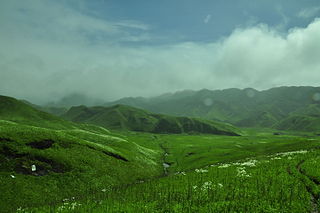
Lilium mackliniae, the Shirui lily or Shirui Kashung Timrawon, is a rare Indian species of plant found only in the upper reaches of the Shirui hill ranges in the Ukhrul district of Manipur, India, at an elevation of 1,730–2,590 metres (5,680–8,500 ft) above sea level. It is located near the boundary of Myanmar to the east, Shirui village in the west, Choithar village in the south and Sihai village in the north.

Kohima, is the capital of the Northeastern Indian state of Nagaland. With a resident population of almost 100,000, it is the second largest city in the state. Originally known as Kewhira, Kohima was founded in 1878 when the British Empire established its headquarters of the then Naga Hills District of Assam Province. It officially became the capital after the state of Nagaland was inaugurated in 1963. Kohima was the site of one of the bloodiest battles of World War II. The battle is often referred to as the ‘Stalingrad of the East’. In 2013, the British National Army Museum voted the Battle of Kohima to be ‘Britain's Greatest Battle’.

Moirang is a small town in the Indian state of Manipur. It is situated approximately 45 km south of the state capital Imphal. It has an area of 269 km2 with a population of 62,187 in 67 villages. Colonel Shaukat Malik of the Indian National Army hoisted the Tricolour for the first time on Indian soil on 14 April 1944.
Sirohi is a city, located in Sirohi district in southern Rajasthan state in western India. It is the administrative headquarters of Sirohi District and was formerly the capital of the princely state of Sirohi ruled by Deora Chauhan Rajput rulers. The nearest railway station to Sirohi is Sirohi Road railway station. Sirohi got first rank in 33 districts of Rajasthan for "Swachha Bharat Abhiyaan” in year 2014.

Lilium philadelphicum, also known as the wood lily, Philadelphia lily, prairie lily, or western red lily, is a perennial species of lily native to North America.

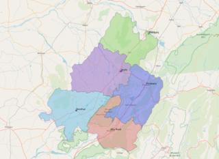
Ukhrul District is an administrative district of the state of Manipur in India with its headquarters at Ukhrul, that is Hunphun. The district occupies the north-eastern corner of the state and it extends between latitudes of 24° 29′ and 25° 42′ N and longitudes 94° 30′ and 94° 45′ E approximately. It shares an international boundary with Myanmar (Burma) on its eastern side and is bounded by Nagaland state in the north, Senapati district and Kangpokpi district in the west and Kamjong district in the south. It has the distinction of being the highest hill station of Manipur. The terrain of the district is hilly with a varying heights of 913 m to 3114 m (MSL). Ukhrul, the district HQ., at an altitude of 2020 m (MSL) is linked with Imphal, the state capital by NH 202 which is about 84 kilometres apart. The district covers an area of 4,544 square kilometres including Kamjong district making it the second largest district of the state after Churachandpur district and has a population of almost 1,83,998 according to Census of India 2011 comprising about 6.44 per cent of the total state population. The Tangkhul Naga tribe constitute the major bulk of the population with other communities such as Thadou, Nepalese and other non-tribals constituting a small percentage of the district population. Administratively, the district which comprises around 200 villages was divided into five sub-divisions, where their boundaries were coterminous with that of the Tribal Development Blocks. There was no statutory town in the district except one census town which was formed in 2011 Census. Recently, Kamjong district was carved out from Ukhrul District as a separate district. Ukhrul District has three assembly constituencies before the bifurcation of the district which are Phungyar Assembly Constituency (43-ST), Ukhrul Assembly Constituency (44-ST) and Chingai Assembly Constituency. The district is best introduced by its rare Shirui Lily,. Also, the district has provided two of Manipur's chief ministers and the only from amongst the hill districts of Manipur, Yangmaso Shaiza the first tribal chief minister of Manipur and Rishang Keishing who is also the first MP from Outer Manipur. William Pettigrew (missionary), an educationist and a Scottish-British Christian Missionary pioneered the western system of education and introduced the Christianity faith among the Tangkhal Naga tribe. Phungyo Baptist Church, Tangrei, Ukhrul, the oldest and the first Christian church of Manipur which still stands today is a testament to his passion for missionary work.

Sirohi District is a district of Rajasthan state in western India. The city of Sirohi is the district headquarters.

Mount Harriet National Park, officially renamed as Mount Manipur National Park, is a national park located in the Andaman and Nicobar Islands union territory of India. The park, established in 1969, covers about 4.62 km2 (18.00 mi2). Mount Manipur, which is a part of the park, is the third-highest peak in the Andaman and Nicobar archipelago next to Saddle Peak in North Andaman and Mount Thullier in Great Nicobar.

Lilium davidii is an Asian species of plants in the lily family, native to mountainous areas of Assam, Manipur, Arunachal Pradesh, Tibet, Bhutan, Hubei, Shaanxi, Sichuan, Guizhou, and Yunnan.
The Dzüko Valley is a valley located at the borders of the states of Nagaland and Manipur in Northeast India. This valley is well known for its natural environment, seasonal flowers and flora & fauna.

Sapria himalayana, commonly known as the hermit's spittoon, is a rare holoparasitic flowering plant related to Rafflesia found in the Eastern Himalayas. Sapria himalayana represents the extreme manifestation of the parasitic mode, being completely dependent on its host plant for water, nutrients and products of photosynthesis which it sucks through a specialised root system called haustoria. These haustoria are attached to both the xylem and the phloem of the host plant.
Sihai is a general reference to a group of villages in the north of Ukhrul District headquarters in Manipur. Sihai Khullen, the nearest from Ukhrul is about 37 kilometers from Ukhrul, connected partially by National Highway 150.

Lilium philippinense, commonly known as the Benguet lily, or Philippine lily, is a lily, native to Taiwan and to the Cordillera region, primarily to the province of Benguet, in the northern Philippines.

Northeast India consists of the eight states Arunachal Pradesh, Assam, Manipur, Meghalaya, Mizoram, Nagaland, Sikkim and Tripura. Tourism in this area is based around the unique Himalayan landscape and culture distinct from the rest of India.
Khamasom is a generic reference to four villages located north of Ukhrul in Ukhrul district, Manipur state, India. The four villages are Khamasom Khayangkho, Khamasom Walely, Khamasom Phungdhar, and Khamasom Phungrei. The settlement is approximately 25 kilometers from Ukhrul and partially connected by National Highway 150, Imphal-Kohima road via Jessami. Khamasom is flanked by Sihai in the south, Huishu in the northwest Nungbi Khullen in the west and Myanmar in the east. The inhabitants speak Khamasom dialect which belongs to the Tibeto-Burman language family. The four villages are under one chieftain.
Shirui, initially called Shiroy/Shiroi, is a village located north of Ukhrul in Ukhrul district, Manipur state, India. The village is 15 kilometers from Ukhrul. National Highway 150 Imphal-Kohima via Jessami passes through the village. The village is divided into two parts, Shirui ato and Shirui aze; however, both the parts are under one chief. Shirui is famous for the rich and flora found on Shirui Kashong or Shirui peak and especially for blooming of the rare Lilium mackliniae during the start of Monsoon. The village is flanked by Ukhrul in the west, Langdang in the south, Mapum in the east, Sihai in the North east and Lunghar in the north. Locally inhabitants speak Shirui dialect which belongs to the Tibeto-Burman language family.
The following outline is provided as an overview of and topical guide to Manipur:
