Transport in Antarctica has transformed from explorers crossing the isolated remote area of Antarctica by foot to a more open era due to human technologies enabling more convenient and faster transport, predominantly by air and water, as well as land. Transportation technologies on a remote area like Antarctica need to be able to deal with extremely low temperatures and continuous winds to ensure the travelers' safety. Due to the fragility of the Antarctic environment, only a limited amount of transport movements can take place and sustainable transportation technologies have to be used to reduce the ecological footprint. The infrastructure of land, water and air transport needs to be safe and sustainable. Currently thousands of tourists and hundreds of scientists a year depend on the Antarctic transportation system.
Vostok Station is a Russian research station in inland Princess Elizabeth Land, Antarctica. Founded by the Soviet Union in 1957, the station lies at the southern Pole of Cold, with the lowest reliably measured natural temperature on Earth of −89.2 °C. Research includes ice core drilling and magnetometry. Vostok was named after Vostok, the lead ship of the First Russian Antarctic Expedition captained by Fabian von Bellingshausen. The Bellingshausen Station was named after this captain..

Dome C, also known as Dome Circe, Dome Charlie or Dome Concordia, located at Antarctica at an elevation of 3,233 metres (10,607 ft) above sea level, is one of several summits or "domes" of the Antarctic Ice Sheet. Dome C is located on the Antarctic Plateau, 1,100 kilometres (680 mi) inland from the French research station at Dumont D'Urville, 1,100 kilometres (680 mi) inland from the Australian Casey Station and 1,200 kilometres (750 mi) inland from the Italian Zucchelli station at Terra Nova Bay. Russia's Vostok Station is 560 kilometres (350 mi) away. Dome C is the site of the Concordia Research Station, jointly operated by France and Italy.

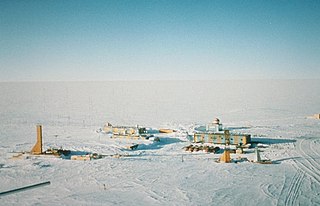
Concordia Research Station, which opened in 2005, is a French–Italian research facility that was built 3,233 m (10,607 ft) above sea level at a location called Dome C on the Antarctic Plateau, Antarctica. It is located 1,100 km (680 mi) inland from the French research station at Dumont D'Urville, 1,100 km (680 mi) inland from Australia's Casey Station and 1,200 km (750 mi) inland from the Italian Zucchelli Station at Terra Nova Bay. Russia's Vostok Station is 560 km (350 mi) away. The Geographic South Pole is 1,670 km (1,040 mi) away. The facility is also located within Australia's claim on Antarctica, the Australian Antarctic Territory.

Kenn Borek Air is an airline based in Calgary, Alberta, Canada. It operates regional passenger and cargo services, contract operations in the Arctic and Antarctic and aircraft leasing. Its main base is at Calgary International Airport. It charters aircraft for scientific expeditions, oil exploration, etc., and operates air ambulance services.

The Rothera Research Station is a British Antarctic Survey (BAS) base on the Antarctic Peninsula, located at Rothera Point, Adelaide Island. Rothera also serves as the capital of the British Antarctic Territory, a British Overseas Territory.
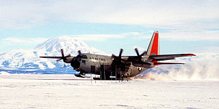
Williams Field or Willy Field is a United States Antarctic Program airfield in Antarctica. Williams Field consists of two snow runways located on approximately 8 meters (25 ft) of compacted snow, lying on top of 8–10 ft of ice, floating over 550 meters (1,800 ft) of water. The airport, which is approximately seven miles from Ross Island, serves McMurdo Station and New Zealand's Scott Base. Until the 2009–10 summer season, Williams was the major airfield for on-continent aircraft operations in Antarctica.

Fossil Bluff is a seasonal British aircraft refuelling station located on the east coast of Alexander Island in Antarctica. In operation since 1961, its facilities provide fuel, storage, and ancillary support for British exploration and operations during the summer season, October through March. The site is adjacent to a natural, north-south travelling route along the George VI Ice Shelf.

Sky Blu is a forward operating station for the British Antarctic Survey located in southern Palmer Land, Antarctica. It is in an area of blue ice, an extremely hard and dense ice which has lost the air bubbles that normally cloud the ice. It provides a runway able to accommodate wheeled aircraft that are larger than can be handled by other types of runways in the area.

Troll Airfield is an airstrip located 6.8 kilometres (4.2 mi) from the research station Troll in Princess Martha Coast in Queen Maud Land, Antarctica. Owned and operated by the Norwegian Polar Institute, it consists of a 3,300-by-100-metre runway on glacial blue ice on the Antarctic ice sheet. The airport is located at 1,232 metres (4,042 ft) above mean sea level and is 235 kilometres (146 mi) from the coast.

Zucchelli Station is an Italian seasonal research station, located at Terra Nova Bay in Antarctica on a granitic headland along the coast of the Northern Foothills to north-east of Gerlache Inlet. It has been named after Mario Zucchelli, director of the activities, which conducted for sixteen years, for the ENEA-Unità Tecnica Antartitide as part of the National Antarctic Research Program (PNRA).

Marble Point is a rocky promontory on the coast of Victoria Land, Antarctica, located at 77° 26' S latitude and 163° 50' E longitude. The United States operates a station at the point. The outpost is used as a helicopter refueling station supporting scientific research in the nearby continental interior such as the McMurdo Dry Valleys. Weather permitting, helicopters are able to fly in and out of the station 24 hours a day during the summer research season.

The Jack F. Paulus Skiway is an airport located at Amundsen–Scott South Pole Station at the South Pole.

Plateau Station is an inactive American research and South Pole—Queen Maud Land Traverse support base on the central Antarctic Plateau. Construction on the site started on December 13, 1965, and the first traverse team arrived in early 1966. The base was in continuous use until January 29, 1969, when it was closed but mothballed for future use, and was the most remote and coldest of any United States stations on the continent. It was also the site for the world's coldest measured average temperature for a month at that time, recorded in July 1968, at −99.8 °F (−73.2 °C).

MeteoSwiss, officially the Federal Office of Meteorology and Climatology, is an office of the federal administration of Switzerland. It employs 290 people at locations in Zurich, Zurich Airport, Geneva, Locarno and Payerne.

Matienzo Base is an Argentine Antarctic base and scientific research station named after Lieutenant Benjamín Matienzo, an Argentine aviation pioneer. It is located in Larsen Nunatak, one of the Foca Nunataks, in Graham Land, Antarctic Peninsula.
National Antarctic Research Program is the Italian Antarctic research program.

Rothera Research Station is the BAS logistics centre for the Antarctic and home of well-equipped biological laboratories and facilities for a wide range of research. The station is situated on a rock and raised beach promontory at the southern extremity of Wormald Ice Piedmont, south-eastern Adelaide Island.

Mid Point is a skiway located in the East Antarctic Ice Sheet at midway between Zucchelli Station and the inland Concordia Station. Mid Point Airstrip, being at 530 kilometres (330 mi) from Zucchelli, is a refuelling place for the aircraft on their way to Concordia. The place is equipped with shelters, meteorological equipment, fuel bladders and tractors to clean the airstrip. An American researchers team lived at the camp for a time, in 2000, to carry out a project of ice drilling.