
The Ganaraska River is a river in Northumberland County and the Regional Municipality of Durham in Southern Ontario, Canada. It is part of the Great Lakes Basin, and is a tributary of Lake Ontario, which it reaches at the central community of the municipality of Port Hope. The river's name is thought to originate from Ganaraske, the name for the Cayuga village which was located at the current site of Port Hope.

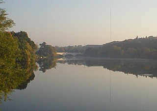
The Humber River is a river in Southern Ontario, Canada. It is in the Great Lakes Basin, is a tributary of Lake Ontario and is one of two major rivers on either side of the city of Toronto, the other being the Don River to the east. It was designated a Canadian Heritage River on September 24, 1999.

The Nottawasaga River is a river in Simcoe County and Dufferin County in Central Ontario, Canada. It is part of the Great Lakes Basin, and is a tributary of Lake Huron. The river flows from the Orangeville Reservoir in the town of Orangeville, Dufferin County, through the Niagara Escarpment and the Minesing Wetlands, the latter a wetland of international significance, and empties into Nottawasaga Bay, an inlet of Georgian Bay on Lake Huron, at the town of Wasaga Beach, Simcoe County.
The Otonabee River is a river in Peterborough County in Central Ontario, Canada. The river flows from Katchewanooka Lake, at the north end of the community of Lakefield, through the city of Peterborough to Rice Lake. It is in the Great Lakes Basin and forms part of the Trent-Severn Waterway.

The Sauble River is a river in Bruce County and Grey County in southwestern Ontario, Canada that flows from its headwaters in the township of Chatsworth to Lake Huron at the community of Sauble Beach.
The Maitland River is a river in Huron County, Perth County and Wellington County in Southwestern Ontario, Canada. The river is in the Great Lakes Basin and empties into Lake Huron at the town of Goderich. It is 150 kilometres (93 mi) long, and is named after Sir Peregrine Maitland, Lieutenant-Governor of Upper Canada from 1818 to 1828. It was formerly known as the Menesetung River.
The Pottawatomi River is a river in the municipalities of Owen Sound and Georgian Bluffs, Grey County in Southwestern Ontario, Canada.It is in the Great Lakes Basin and empties into Owen Sound, an inlet of Georgian Bay on Lake Huron, at Owen Sound Harbour.

The Crowe River is a river in the counties of Haliburton, Hastings, Northumberland and Peterborough in southern Ontario, Canada. It is in the Lake Ontario drainage basin and is a tributary of the Trent River.
The Teeswater River is a river in the municipalities of Arran–Elderslie, Brockton and South Bruce in Bruce County in Southwestern Ontario, Canada. It is in the Great Lakes Basin and empties into the Saugeen River at Paisley, Ontario.

Sixteen Mile Creek is a river in Halton Region in the Greater Toronto Area of Ontario, Canada. It is in the Great Lakes Basin, and flows from the Niagara Escarpment through the towns of Milton and Oakville to Lake Ontario.
Lake Gibson is a lake near Thorold in the Regional Municipality of Niagara, Ontario, Canada. The lake is not natural, but rather was created as a reservoir for hydroelectric power generation at the Ontario Power Generation Decew Falls 1 and Decew Falls 2 generating stations. The lake was created by flooding the shallow valley of Beaverdams Creek. Lake Moodie is located to the northwest of Lake Gibson and is a smaller segment of the overall Lake Gibson system. Almost all of the water supply to these lakes comes from Lake Erie via the Welland Canal. The lakes suck part of the Twelve Mile Creek watershed.
Coyle Creek is a small creek in the municipalities of Welland, Pelham, and West Lincoln in Ontario, Canada, that forms an important component of the Welland River watershed. The last section of the creek constitutes an oasis of wild habitat in an otherwise increasingly developed area; the upper section of the creek runs through a golf course.
The Twenty Mile Creek is a minor waterway, located in the Niagara Peninsula, Ontario, Canada. The creek is named for the location of its mouth, twenty miles (32 km) west of the Niagara River along the Lake Ontario shoreline. The Indian name for the Twenty Mile Creek was the Kenachdaw, which translates to Lead River.

Twelve Mile Creek is a waterway located on the Niagara Peninsula in the Regional Municipality of Niagara in Southern Ontario, Canada. Its headwaters are located in the town of Pelham, encompassing some of the most unspoiled and natural areas of Niagara area. The creek's lower reaches flow through urban areas of Thorold and St. Catharines, and have been heavily altered by human activity for almost two centuries.
Sixteen Mile Creek is a stream in the municipality of Lake of Bays, District Municipality of Muskoka in Central Ontario, Canada. It is part of the Great Lakes Basin and flows from Hickory Lake to its mouth at the Boyne River. The Boyne River flows to the Lake of Bays, then via the Muskoka River, and the Moon River and Musquash River to Georgian Bay on Lake Huron.
The Boyne River is a river in the municipality of Lake of Bays, District Municipality of Muskoka in Central Ontario, Canada. It is part of the Great Lakes Basin, and flows from Fowler Lake to its mouth at Dwight Bay on the Lake of Bays near the community of Dwight on Ontario Highway 60. The Lake of Bays flows via the Muskoka River, then the Moon River and Musquash River to Georgian Bay on Lake Huron.
The Boyne River is a river in Simcoe County and Dufferin County in Central Ontario, Canada. It is part of the Great Lakes Basin, and is a left tributary of the Nottawasaga River. The rivers falls within the jurisdiction of the Nottawasaga Valley Conservation Authority.

The Beaver River is a river in Grey County and Simcoe County in Southern Ontario, Canada. It is part of the Great Lakes Basin, and is a tributary of Lake Huron. The river's drainage basin is under the auspices of Grey Sauble Conservation.
The Beaver River is a river in Durham Region in Central Ontario, Canada. It is part of the Great Lakes Basin, and is a tributary of Lake Simcoe. The river's drainage basin is mostly in Durham Region with the remaining portion in the city of Kawartha Lakes; the entire watershed is under the auspices of the Lake Simcoe Region Conservation Authority.

The Black River is a river in the Regional Municipality of York and the Regional Municipality of Durham in Central Ontario, Canada. It is part of the Great Lakes Basin, and is a tributary of Lake Simcoe; the entire watershed is under the auspices of the Lake Simcoe Region Conservation Authority.

