Slapes Corner, New Jersey

Last updated
Slapes Corner, New Jersey
Unincorporated community
Location map of Salem County, New Jersey.svg
Red pog.svg
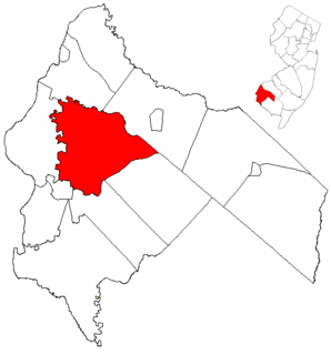
Slapes Corner, New Jersey
Slapes Corner's location in Salem County (Inset: Salem County in New Jersey)
USA New Jersey location map.svg
Red pog.svg
Slapes Corner, New Jersey
Slapes Corner, New Jersey (New Jersey)
Usa edcp location map.svg
Red pog.svg
Slapes Corner, New Jersey
Slapes Corner, New Jersey (the US)
Coordinates: 39°38′23″N75°26′9″W / 39.63972°N 75.43583°W / 39.63972; -75.43583 Coordinates: 39°38′23″N75°26′9″W / 39.63972°N 75.43583°W / 39.63972; -75.43583
Country Flag of the United States.svg  United States
State Flag of New Jersey.svg  New Jersey
County Salem
Township Mannington
Elevation [1] 5 m (16 ft)
Time zone Eastern (EST) (UTC-5)
  Summer (DST) EDT (UTC-4)
GNIS feature ID 880640 [1]

Slapes Corner is an unincorporated community located within Mannington Township, in Salem County, New Jersey, United States. [1] [2] [3]

Mannington Township, New Jersey Township in New Jersey

Mannington Township is a township in Salem County, New Jersey, United States. As of the 2010 United States Census, the township's population was 1,806, reflecting an increase of 247 (+15.8%) from the 1,559 counted in the 2000 Census, which had in turn declined by 134 (-7.9%) from the 1,693 counted in the 1990 Census.

Salem County, New Jersey county in New Jersey, United States

Salem County is a county located in the U.S. state of New Jersey. Its western boundary is formed by the Delaware River and it has the eastern terminus of the Delaware Memorial Bridge, connecting to New Castle, Delaware. Its county seat is Salem. The county is part of the Delaware Valley area. As of the 2017 Census estimate, the county's population was 62,792, making it the state's least populous county, representing a 5.0% decrease from the 66,083 enumerated at the 2010 Census, in turn increasing by 1,798 (+2.8%) from the 64,285 counted in the 2000 Census, retaining its position as the state's least populous county. The most populous place was Pennsville Township, with 13,409 residents at the time of the 2010 Census. Lower Alloways Creek Township covers 72.46 square miles (187.7 km2), the largest total area of any municipality.

New Jersey State of the United States of America

New Jersey is a state in the Mid-Atlantic region of the Northeastern United States. It is a peninsula, bordered on the north and east by the state of New York, particularly along the extent of the length of New York City on its western edge; on the east, southeast, and south by the Atlantic Ocean; on the west by the Delaware River and Pennsylvania; and on the southwest by the Delaware Bay and Delaware. New Jersey is the fourth-smallest state by area but the 11th-most populous, with 9 million residents as of 2017, and the most densely populated of the 50 U.S. states; its biggest city is Newark. New Jersey lies completely within the combined statistical areas of New York City and Philadelphia and was the second-wealthiest U.S. state by median household income as of 2017.

The community is centered at County Route 540, Marshalltown Road and Pointers Auburn Road, located 1.0 mile (1.6 km) east of Marshalltown and 3.4 miles (5.5 km) east-southeast of Glenside. [4]

County Route 540 (New Jersey) highway in New Jersey

County Route 540, abbreviated CR 540, is a county highway in the U.S. state of New Jersey. The highway extends 43.16 miles (69.46 km) from the intersection of U.S. Route 130 and Route 140 in Carneys Point Township to Harding Highway in Buena Vista Township.

Marshalltown, New Jersey Unincorporated community in New Jersey, United States

Marshalltown is an unincorporated community located within Mannington Township, in Salem County, New Jersey, United States.

Related Research Articles

East Amwell Township, New Jersey Township in New Jersey

East Amwell Township is a township in Hunterdon County, New Jersey, United States. As of the 2010 United States Census, the township's population was 4,013, reflecting a decline of 442 (-9.9%) from the 4,455 counted in the 2000 Census, which had in turn increased by 123 (+2.8%) from the 4,332 counted in the 1990 Census.

New York State Route 75 highway in New York

New York State Route 75 (NY 75) is a north–south state highway in Erie County, New York, in the United States. It extends for 20.85 miles (33.55 km) from an intersection with NY 39 in the Collins hamlet of Collins Center to an interchange with NY 5 in the town of Hamburg. The route passes through the village of Hamburg, which serves as the northern terminus of a 2-mile (3.2 km) overlap between U.S. Route 62 (US 62) and NY 75. Past Hamburg, NY 75 connects to the New York State Thruway northwest of the village before ending a short distance from Lake Erie. The portion of NY 75 south of Hamburg is a two-lane rural highway; in contrast, the section north of the village is four lanes wide and serves commercial and residential areas.

U.S. Highway 30 (US 30) is a major east–west U.S. Highway which spans 330 miles (530 km) across the state of Iowa. It is the longest primary highway in the state and is maintained by the Iowa Department of Transportation. The route in Iowa begins at the Missouri River crossing at Blair, Nebraska, and ends at the Mississippi River crossing at Clinton. Along the way, it serves Denison and Carroll in western Iowa, Boone, Ames, and Marshalltown in central Iowa, and Tama, Cedar Rapids, and DeWitt in eastern Iowa. Cutting across the central portion of the state, US 30 runs within close proximity of the Union Pacific Railroad's Overland Route for its entire length.

New Lisbon, New Jersey Unincorporated community in New Jersey, United States

New Lisbon is an unincorporated community located within Pemberton Township in Burlington County, New Jersey, United States. It is a settlement along Four Mile Road where it intersects Mount Misery Road. The community is located along the Philadelphia and Long Branch Railway, later a part of the Pennsylvania Railroad, and featured a train station.

West Portal, New Jersey Unincorporated community in New Jersey, United States

West Portal is an unincorporated community located within Bethlehem Township, in Hunterdon County, New Jersey, United States.

Ewan, New Jersey Unincorporated community in New Jersey, United States

Ewan is an unincorporated community located within Harrison Township, in Gloucester County, New Jersey, United States. The area is served by the United States Postal Service as ZIP code 08025.

Swinesburg, New Jersey Unincorporated community in New Jersey, United States

Swinesburg is an unincorporated community located along the border of Alexandria and Bethlehem townships in Hunterdon County, New Jersey, United States.

Valley, New Jersey Unincorporated community in New Jersey, United States

Valley is an unincorporated community located within Bethlehem Township, in Hunterdon County, New Jersey, United States.

Allerton, New Jersey Unincorporated community in New Jersey, United States

Allerton is an unincorporated community located within Clinton Township, in Hunterdon County, New Jersey, United States.

McPherson, New Jersey Unincorporated community in New Jersey, United States

McPherson is an unincorporated community located within Clinton Township, in Hunterdon County, New Jersey, United States.

Readingsburgh, New Jersey Unincorporated community in New Jersey, United States

Readingsburgh is an unincorporated community located within Clinton Township, in Hunterdon County, New Jersey, United States.

Acton, New Jersey Unincorporated community in New Jersey, United States

Acton is an unincorporated community located within Mannington Township, in Salem County, New Jersey, United States.

Halltown, New Jersey Unincorporated community in New Jersey, United States

Halltown is an unincorporated community located within Mannington Township, in Salem County, New Jersey, United States.

Portertown, New Jersey Unincorporated community in New Jersey, United States

Portertown is an unincorporated community located within Mannington Township, in Salem County, New Jersey, United States.

Welchville, New Jersey Unincorporated community in New Jersey, United States

Welchville is an unincorporated community located within Mannington Township, in Salem County, New Jersey, United States.

Harneys Corner, New Jersey Unincorporated community in New Jersey, United States

Harneys Corner is an unincorporated community located within Lawrence Township in Mercer County, New Jersey, United States. It is located at the intersection of Lawrence Road and Princeton Pike / Avenue. Located in the southern portion of the township close to the Trenton and Ewing borders, the area consists of small houses on nearby side streets and businesses along the aforementioned arterial roads. The intersection itself is located about 0.3 miles (0.48 km) north of the Brunswick Circle.

Ackors Corner, New Jersey Unincorporated community in New Jersey, United States

Ackors Corner is an unincorporated community located within Hopewell Township in Mercer County, New Jersey, United States. The settlement is located at the intersection of Bear Tavern Road / Trenton-Harbourton Road, Pennington-Harbourton Road and Pleasant Valley Road. It is named for the Ackors family which owned land near the current intersection. Small residences and farmland make up the area surrounding Ackors Corner but the area rises in elevation from east to west as one approaches Baldpate Mountain, part of the Sourland Mountain range.

Pages Corners, New Jersey Unincorporated community in New Jersey, United States

Pages Corners or Pages Corner is an unincorporated community located within Robbinsville Township in Mercer County, New Jersey, United States. The intersection defining the corners is at Sharon Road and Gordon Road. The intersection is at a skewed angle which led to numerous accidents. The township installed a traffic signal at the intersection and activated it on September 25, 2015.

Crawford Corners, New Jersey Unincorporated community in New Jersey, United States

Crawford Corners or Crawfords Corner is an unincorporated community located within Holmdel Township in Monmouth County, New Jersey, United States. The settlement is located at the intersection of Holmdel Road and Crawfords Corners Road in the hilly northern portion of the township. The settlement is located about one-half mile (0.80 km) from Crawford Hill, the highest point in Monmouth County. The area also includes the township's town hall, police department, and high school in addition to a New Jersey State Police barracks and the PNC Bank Arts Center off the Garden State Parkway. These buildings and landmarks comprise the eastern section of the settlement, homes and heavily treed lands are located on the west side of Holmdel Road, and Holmdel Park makes up the southern portion of the area.

References

  1. 1 2 3 Feature Detail Report for: Slapes Corner, Geographic Names Information System. Accessed January 1, 2015.
  2. Locality Search, State of New Jersey. Accessed January 1, 2015.
  3. Areas covering the point (-75.435833,39.639722), MapIt. Accessed January 1, 2015.
  4. N 39.639722 W 75.435833, ACME Mapper. Accessed January 1, 2015.