South Sanford, Maine

Last updated • 2 min readFrom Wikipedia, The Free Encyclopedia
South Sanford, Maine
USA Maine location map.svg
Red pog.svg
South Sanford
Location within the state of Maine
Coordinates: 43°24′7″N70°42′35″W / 43.40194°N 70.70972°W / 43.40194; -70.70972
Country United States
State Maine
County York
Area
  Total23.4 sq mi (60.7 km2)
  Land22.8 sq mi (59.0 km2)
  Water0.7 sq mi (1.7 km2)
Elevation
282 ft (86 m)
Population
 (2010)
  Total4,536
  Density199/sq mi (76.9/km2)
Time zone UTC-5 (Eastern (EST))
  Summer (DST) UTC-4 (EDT)
Area code 207
FIPS code 23-72200
GNIS feature ID0575904

South Sanford is a former census-designated place (CDP) in the city of Sanford in York County, Maine, United States. The population was 4,536 at the 2010 census. [1] It is part of the Portland South Portland Biddeford, Maine Metropolitan Statistical Area. The CDP was abolished when the town of Sanford re-incorporated as a city.

Contents

Geography

South Sanford is located at 43°24′7″N70°42′35″W / 43.40194°N 70.70972°W / 43.40194; -70.70972 (43.401854, -70.709820). [2]

According to the United States Census Bureau, the CDP has a total area of 23.4 square miles (60.7 km2), of which 22.8 square miles (59.0 km2) is land and 0.7 square miles (1.7 km2), or 2.87%, is water. [1]

Demographics

At the 2010 census, there were 4,536 people, 1,859 households and 1,230 families residing in the CDP. The population density was 198.9 inhabitants per square mile (76.8/km2). There were 2,111 housing units at an average density of 92.6 per square mile (35.8/km2). The racial makeup of the CDP was 94.8% White, 0.4% African American, 0.3% Native American, 2.8% Asian, 0.2% some other race, and 1.5% from two or more races. Hispanic or Latino of any race were 1.5% of the population. [3]

There were 1,859 households, out of which 29.9% had children under the age of 18 living with them, 50.9% were headed by married couples living together, 9.5% had a female householder with no husband present, and 33.8% were non-families. 26.5% of all households were made up of individuals, and 11.4% were someone living alone who was 65 years of age or older. The average household size was 2.43, and the average family size was 2.91. [3]

22.0% of the population were under the age of 18, 7.3% from 18 to 24, 24.0% from 25 to 44, 31.2% from 45 to 64, and 15.4% who were 65 years of age or older. The median age was 42.6 years. For every 100 females, there were 97.4 males. For every 100 females age 18 and over, there were 92.8 males. [3]

For the period 2007–2011, the estimated median household income was $54,850 and the median family income was $56,771. Male full-time workers had a median income of $46,134 compared with $34,688 for females. The per capita income was $25,894. About 5.8% of families and 7.4% of the population were below the poverty line, including 6.8% of those under age 18 and 14.2% of those age 65 or over. [4]

Related Research Articles

<span class="mw-page-title-main">Cumberland Center, Maine</span> Census-designated place in Maine, United States

Cumberland Center is a census-designated place (CDP) within the town of Cumberland in Cumberland County, Maine, United States. The population was 2,499 at the 2010 census. It is part of the Portland – South Portland – Biddeford, Maine, Metropolitan Statistical Area.

<span class="mw-page-title-main">Falmouth Foreside</span> Census-designated place in Maine, United States

Falmouth Foreside is a census-designated place (CDP) within the town of Falmouth in Cumberland County, Maine, United States. As of the 2010 census, the CDP population was 1,511. It is part of the Portland–South Portland–Biddeford, Maine Metropolitan Statistical Area.

<span class="mw-page-title-main">North Windham, Maine</span> Census-designated place in Maine, United States

North Windham is a census-designated place (CDP) within the town of Windham in Cumberland County, Maine, United States. The population was 4,904 at the 2010 census. It is part of the Portland–South Portland–Biddeford, Maine Metropolitan Statistical Area.

Lake Arrowhead is a census-designated place (CDP) in the towns of Waterboro and Limerick in York County, Maine, United States. The population was 3,071 at the 2010 census. The CDP corresponds to the area covered by the Lake Arrowhead Community, a large subdivision begun in the 1960s which surrounds Lake Arrowhead, an artificial lake on the Little Ossipee River. The community is part of the Portland–South Portland–Biddeford, Maine Metropolitan Statistical Area.

<span class="mw-page-title-main">South Eliot, Maine</span> Census-designated place in Maine, United States

South Eliot is a census-designated place (CDP) in the town of Eliot in York County, Maine, United States. The population was 3,550 at the 2010 census. It is part of the Portland–South Portland–Biddeford, Maine Metropolitan Statistical Area.

<span class="mw-page-title-main">Springvale, Maine</span> Place in Maine, United States

Springvale is a village and former census-designated place in the city of Sanford in York County, Maine, United States. The population was 3,292 at the 2010 census. It is part of the Portland–South Portland–Biddeford, Maine metropolitan statistical area. The CDP was abolished when the town of Sanford reincorporated as a city.

<span class="mw-page-title-main">West Kennebunk, Maine</span> Census-designated place in Maine, United States

West Kennebunk is a census-designated place (CDP) in the town of Kennebunk in York County, Maine, United States. The population was 1,176 at the 2010 census. It is part of the Portland–South Portland–Biddeford, Maine Metropolitan Statistical Area.

<span class="mw-page-title-main">Suncook, New Hampshire</span> Census-designated place in New Hampshire, United States

Suncook is a census-designated place (CDP) in Merrimack County, New Hampshire, United States. The population was 5,501 at the 2020 census. Approximately two-thirds of Suncook is located in the town of Pembroke, with the remainder in Allenstown.

<span class="mw-page-title-main">Felida, Washington</span> Census-designated place in Washington, United States

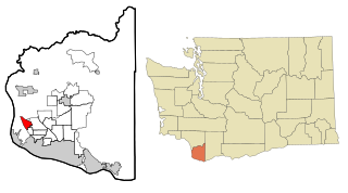
Felida is a census-designated place (CDP) in Clark County, Washington, United States. The population was 9,526 at the 2020 census.

<span class="mw-page-title-main">Oak Hill, Maine</span> Census-designated place in Maine, United States

Oak Hill is a census-designated place (CDP) in the town of Scarborough in Cumberland County, Maine, United States. Prior to the 2020 census, the CDP was known as Scarborough. The population was 4,403 at the 2010 census. It is part of the Portland–South Portland–Biddeford, Maine Metropolitan Statistical Area.

<span class="mw-page-title-main">Kennebunk (CDP), Maine</span> Census-designated place in Maine, United States

Kennebunk is a census-designated place (CDP) comprising the central village in the town of Kennebunk in York County, Maine, United States. The population was 5,214 at the 2010 census, out of a total town population of 10,798. It is part of the Portland–South Portland–Biddeford, Maine Metropolitan Statistical Area.

<span class="mw-page-title-main">Kennebunkport (CDP), Maine</span> Census-designated place in Maine, United States

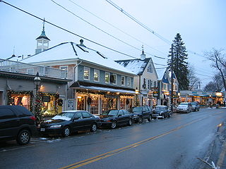
Kennebunkport is a census-designated place (CDP) consisting of the central village in the town of Kennebunkport in York County, Maine, United States. The population was 1,238 at the 2010 census, out of a total town population of 3,474. It is part of the Portland–South Portland–Biddeford, Maine Metropolitan Statistical Area.

<span class="mw-page-title-main">Kittery (CDP), Maine</span> Census-designated place in Maine, United States

Kittery is a census-designated place (CDP) consisting of the main village in the town of Kittery in York County, Maine, United States. The village is also known as Kittery Foreside. The population of the CDP was 4,562 at the 2010 census. It is part of the Portland–South Portland–Biddeford, Maine Metropolitan Statistical Area.

<span class="mw-page-title-main">North Berwick (CDP), Maine</span> Census-designated place in Maine, United States

North Berwick is a census-designated place (CDP) consisting of the primary settlement in the town of North Berwick in York County, Maine, United States. The population was 1,615 at the 2010 census, out of a total town population of 4,576. It is part of the Portland–South Portland–Biddeford, Maine Metropolitan Statistical Area.

<span class="mw-page-title-main">Sanford (CDP), Maine</span> Census-designated place in Maine, United States

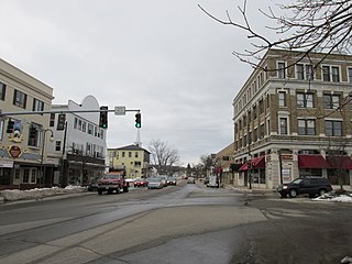
Sanford is a former census-designated place (CDP) comprising the downtown portion of the city of Sanford in York County, Maine, United States. The population of the CDP was 9,761 at the 2010 census. The CDP was abolished after the town of Sanford reincorporated as a city.

<span class="mw-page-title-main">Livermore Falls (CDP), Maine</span> Census-designated place in Maine, United States

Livermore Falls is a census-designated place (CDP) in the town of Livermore Falls in Androscoggin County, Maine, United States. The population of the CDP was 1,594 at the 2010 census, out of a population of 3,187 within the full town.

<span class="mw-page-title-main">Freeport (CDP), Maine</span> Census-designated place in Maine, United States

Freeport is a census-designated place (CDP) in the town of Freeport in Cumberland County, Maine, United States. The population was 1,485 at the 2010 census. It is part of the Portland–South Portland–Biddeford, Maine Metropolitan Statistical Area.

<span class="mw-page-title-main">Gorham (CDP), Maine</span> Census-designated place in Maine, United States

Gorham is a census-designated place (CDP) in the town of Gorham, in Cumberland County, Maine, United States. The population was 6,882 at the 2010 census. It is part of the Portland–South Portland–Biddeford, Maine Metropolitan Statistical Area.

<span class="mw-page-title-main">Yarmouth (CDP), Maine</span> Census-designated place in Maine, United States

Yarmouth is a census-designated place (CDP) in the town of Yarmouth in Cumberland County, Maine, United States. The population was 6,125 at the 2020 census. It is part of the Portland–South Portland–Biddeford, Maine Metropolitan Statistical Area.

<span class="mw-page-title-main">Berwick (CDP), Maine</span> Census-designated place in Maine, United States

Berwick is a census-designated place (CDP) in the town of Berwick in York County, Maine, United States. The population was 2,187 at the 2010 census, out of a total of 7,246 in the entire town. It is part of the Portland–South Portland–Biddeford, Maine Metropolitan Statistical Area.

References

  1. 1 2 "Geographic Identifiers: 2010 Demographic Profile Data (G001): South Sanford CDP, Maine". U.S. Census Bureau, American Factfinder. Archived from the original on February 12, 2020. Retrieved January 29, 2013.
  2. "US Gazetteer files: 2010, 2000, and 1990". United States Census Bureau. 2011-02-12. Retrieved 2011-04-23.
  3. 1 2 3 "Profile of General Population and Housing Characteristics: 2010 Demographic Profile Data (DP-1): South Sanford CDP, Maine". U.S. Census Bureau, American Factfinder. Archived from the original on February 12, 2020. Retrieved January 29, 2013.
  4. "Selected Economic Characteristics: 2007-2011 American Community Survey 5-Year Estimates (DP03): South Sanford CDP, Maine". U.S. Census Bureau, American Factfinder. Archived from the original on February 12, 2020. Retrieved January 29, 2013.