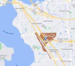
Southpoint | |
---|---|
ZIP Code | 32216, 32217, 32256 [1] |
Area code(s) | 904 [1] |
Southpoint is a commercial section of Jacksonville, Florida on the city's Southside area, eight miles from Downtown. The area is composed primarily of commercial buildings, apartment complexes and professional office centers.
Southpoint is located in the fast-growing southeast quadrant of Jacksonville, along J. Turner Butler Boulevard, an expressway which serves as a major thoroughfare to and from the Jacksonville Beaches. [2] [3] [4] [5] [6]
Southpoint's boundaries are Bowden Road to the north, Belfort Road to the east, Butler Boulevard to the south and Interstate 95 to the west. Some businesses between I-95 and Philips Highway use Southpoint to reference their location, and there are many small hotels on that strip of land. Streets within Southpoint include Southpoint Parkway, Southpoint Drive North & South, Southpoint Boulevard, and Salisbury Road.
When the initial segment of J. Turner Butler Boulevard (State Road 202) was completed in 1979, access to land around Butler Blvd improved, facilitating development of the area east of Interstate 95. Gate Petroleum partnered with the Bryant Skinner Company in 1980 to create the 250-acre (1.0 km2)Southpoint office park [7] and the area northeast of the intersection became Southpoint.
St. Lukes Hospital, built in 1984, is on the corner of Southpoint. It is now known as St. Vincent's Medical Center Southside. Many of the hospital's doctors have offices in Southpoint and employees live in nearby apartments.
The population is 8,078, primarily young professionals and families who rent and are political moderates. [8]
VA Clinic Southpoint "The Southpoint facility is 30,000 square feet, according to the VA. It provides primary care, mental health treatment, physical therapy, occupational therapy, traumatic brain injury treatment and prosthetics." [9]
Interstate 295 (I-295), an auxiliary route of Interstate 95, is a beltway around central Jacksonville, Florida. The 60.9 miles (98.0 km)-long beltway consists of two segments, the West Beltway, and the East Beltway, with I-95 serving as the dividing line between the two. The entire highway carries a hidden designation as State Road 9A by the Florida Department of Transportation. The West Beltway was constructed in the 1970s, with the East Beltway being built from the 1980s-2000s.
The Jacksonville Transportation Authority (JTA) is the independent agency responsible for public transit in the city of Jacksonville, Florida, and roadway infrastructure that connects northeast Florida. However, they do not maintain any roadways.
State Road 202 (SR 202) is a 13.042-mile-long (20.989 km) state highway that extends from U.S. Route 1, in Jacksonville, Florida to SR A1A, in Jacksonville Beach, near the Atlantic Ocean, just north of Ponte Vedra Beach, and includes a bridge over the Intracoastal Waterway. To locals, the road is better known as J. Turner Butler Boulevard, Butler Boulevard, or JTB. Except for a 0.5-mile-long (800 m) section from US 1 to Interstate 95 (I-95), it is a completely limited-access expressway. It was constructed in sections by the Jacksonville Transportation Authority. The first section opened in 1979, but the entire road was not completed until 1997.
The Southside of Richmond is an area of the Metropolitan Statistical Area surrounding Richmond, Virginia. It generally includes all portions of the City of Richmond which lie south of the James River, and includes all of the former city of Manchester. Depending on context, the term "Southside of Richmond" can include some northern areas of adjacent Chesterfield County, Virginia in the Richmond-Petersburg region. With minor exceptions near Bon Air, VA, the Chippenham Parkway forms the border between Chesterfield County and the City of Richmond portions of Southside, with some news agencies using the term "South Richmond" to refer to the locations in Southside located in the city proper.
The Jacksonville Metropolitan Area, also called the First Coast, Metro Jacksonville, or Northeast Florida, is the metropolitan area centered on the principal city of Jacksonville, Florida and including the First Coast of North Florida. According to the 2020 United States Census, the total population was 1,605,848. The Jacksonville–St. Marys–Palatka, FL–GA Combined Statistical Area (CSA) had a population of 1,733,937 in 2020 and was the 34th largest CSA in the United States. The Jacksonville metropolitan area is the 40th largest in the country and the fourth largest in the State of Florida, behind the Miami, Tampa, and Orlando metropolitan areas.The Jacksonville Metropolitan Area, also called Greater Jacksonville, Metro Jacksonville, Northeast Florida, and known regionally as is the metropolitan area centered on the principal city of Jacksonville, Florida and including the First Coast of North Florida. According to the 2020 United States Census, the total population was 1,605,848. The Jacksonville–St. Marys–Palatka, FL–GA Combined Statistical Area (CSA) had a population of 1,733,937 in 2020 and was the 34th largest CSA in the United States. The Jacksonville metropolitan area is the 40th largest in the country and the fourth largest in the State of Florida, behind the Miami, Tampa, and Orlando metropolitan areas.The Jacksonville Metropolitan Area, also called the First Coast, Metro Jacksonville, or Northeast Florida is the metropolitan area centered on the principal city of Jacksonville, Florida and including the First Coast of North Florida. According to the 2020 United States Census, the total population was 1,605,848. The Jacksonville–St. Marys–Palatka, FL–GA Combined Statistical Area (CSA) had a population of 1,733,937 in 2020 and was the 34th largest CSA in the United States. The Jacksonville metropolitan area is the 40th largest in the country and the fourth largest in the State of Florida, behind the Miami, Tampa, and Orlando metropolitan areas.
Interstate 95 (I-95) is the main Interstate Highway of Florida's Atlantic Coast. It begins at a partial interchange with U.S. Highway 1 (US 1) just south of downtown Miami, and heads north past Daytona Beach, through Jacksonville, and to the Georgia state line at the St. Marys River near Becker. The route also passes through the cities of Fort Lauderdale, West Palm Beach, and Titusville.
State Road 115 is a state highway in the U.S. state of Florida.
The Jacksonville Expressway Authority was an independent entity established by the Florida Legislature in 1955. They owned and maintained roads and bridges in Duval County, including several toll bridges, mostly across the St. Johns River. In 1971 the Authority merged with City Coach Company and several smaller private bus companies to form the Jacksonville Transportation Authority. Tolls were removed in 1988, and the Florida Department of Transportation now maintains the bridges and freeways.
There are more than 500 neighborhoods within the area of Jacksonville, Florida, the largest city in the contiguous United States by area. These include Downtown Jacksonville and surrounding neighborhoods. Additionally, greater Jacksonville is traditionally divided into several major sections with amorphous boundaries: Northside, Westside, Southside, and Arlington, as well as the Jacksonville Beaches.
Beach Boulevard is an east–west road running from Jacksonville, Florida, United States east to Jacksonville Beach. Most of the road is part of U.S. Route 90 and unsigned as State Road 212, and a small portion at the eastern end is unsigned as County Road 212.
The Better Jacksonville Plan is a growth management plan implemented by the city of Jacksonville, Florida. It was the signature project of Mayor John Delaney. It was approved by Jacksonville voters on September 5, 2000. Lex Hester was a key advisor to Delaney on the $2.25 billion package of projects, pushing for the inclusion of a new downtown library, then serving on the team of top administrators charged with making the far-reaching plan work. The BJP was codified as Section 761 of Jacksonville's Code of Ordinances and administered by the City of Jacksonville, the JEA, and the Jacksonville Transportation Authority, in cooperation with the Florida Department of Transportation. A Sunset provision will terminate the half-penny sales tax used as part of funding the program, to be completed around 2010, no later than 2030.
State Road 152 (SR 152), locally known as Baymeadows Road, is a 6.4-mile (10.3 km) state highway in Jacksonville, within the northeastern part of the U.S. state of Florida. It is a main east-west road in Southside Jacksonville, extending from an intersection with SR 13 in the west to an interchange with I-295 in the east.
The Pottsburg Creek is an urban creek in Jacksonville, Florida. Its beginning is near a retention pond behind the old studios of WJXX. It outputs into the Arlington River which in turn empties into the St. Johns River. The creek primarily flows through the heart of Jacksonville's Southside, and through southern parts of the Arlington neighborhood.
Mayo Clinic Florida is a comprehensive medical center belonging to the Mayo Clinic in Jacksonville, Florida. It is one of three Mayo campuses along with Phoenix/Scottsdale, Arizona and Rochester, Minnesota.
The Jacksonville transportation network includes ground, air, and sea options for passenger and freight transit. The Jacksonville Port Authority (Jaxport) operates the Port of Jacksonville, which includes container shipping facilities at Blount Island Marine Terminal, the Talleyrand Marine Terminal and the Dames Point Marine Terminal. Jacksonville Aviation Authority managers Jacksonville International Airport in Northside, as well as several smaller airports. The Jacksonville Transportation Authority (JTA) operates bus, people mover, and park-n-ride services throughout the city and region. A major bus terminal at the intermodal Rosa Parks Transit Station serves as JTA's main transit hub. Various intercity bus companies terminate near Central Station. Amtrak operates passenger rail service to and from major cities throughout North America. The city is bisected by major highways, I-95 and I-10, I-295 creates a full beltway around the city.
Deerwood is a gated community and country club in Jacksonville, Florida, US. After it was established in the mid-1960s, it was the most exclusive residential area on Jacksonville's Southside. The golf course hosted the Greater Jacksonville Open in the late 1960s and early 1970s, forerunner of The Players Championship, and was once the site of talks between President Gerald Ford and Egyptian President Anwar Sadat in November 1975.
St. Vincent's Medical Center Southside is a not-for-profit, faith-based hospital located in the southern part of Jacksonville, Florida. It is a member of St. Vincent's HealthCare and is affiliated with Ascension Health. Founded as St. Luke's Hospital in 1873, it was Jacksonville's first private hospital and is Florida's oldest private hospital.
St. Vincent's HealthCare, based in Jacksonville, Florida is a network of three acute-care hospitals, a long-term skilled nursing facility, 30+ primary care centers, nearly a dozen medical laboratories, transportation and prescription services, and a health outreach ministry. It is part of Ascension, the largest Catholic hospital system in the United States.
Arlington is a large region of Jacksonville, Florida, and is generally understood as a counterpart to the city's other large regions, the Urban Core, Northside, Southside, Westside, and the Beaches. It borders the Southside area at its southern end, and has several bridge connections to nearby beaches, the Northside and Downtown. The expansive neighborhood was incorporated into the city in 1968 as a result the Jacksonville Consolidation, a city-county consolidation of the governments of the City of Jacksonville and Duval County. Arlington is known for its mid-century modern architecture, and contains several architectural significant homes designed by local architects Robert C. Broward, Taylor Hardwick, and William Morgan.
The First Coast Flyer is a bus rapid transit (BRT) system in Jacksonville, Florida, owned and operated by the Jacksonville Transportation Authority (JTA). It currently consists of four radial routes running north, southwest, southeast, and east from the Jacksonville Regional Transportation Center in Downtown Jacksonville, where it connects to the Jacksonville Skyway. The first phase, including stations in Downtown Jacksonville and the northbound Green Line, opened in December 2015, with the southbound Blue Line opening in 2016. Additional phases, including the eastbound Red Line and southwestern Orange Line opened in 2018 and 2021, respectively.