Downtown Jacksonville

Last updated

Downtown Jacksonville
DT Jax 2022.jpg
Downtown Jacksonville in 2022
Jacksonville Urban Core.png
Red pog.svg
Downtown Jacksonville
Central Jacksonville
Coordinates: 30°19′40″N81°39′36″W / 30.32764°N 81.66012°W / 30.32764; -81.66012
Government
   City Council LeAnna Cumber,
Reggie Gaffney,
Don Redmon (former),
Warren A. Jones (former),
Dr. Johnny Gaffney (former)
   State Assembly Reggie Fullwood (former)
   State Senate Audrey Gibson
   U.S. House Aaron Bean (R)
Area
  Total10.1 km2 (3.91 sq mi)
  Land7.1 km2 (2.75 sq mi)
Population
 (2015) [1]
  Total8,000
  Density790/km2 (2,000/sq mi)
ZIP Code
32202,32207
Area code 904
Website downtownjacksonville.com

Downtown Jacksonville is the historic core and central business district (CBD) of Jacksonville, Florida. It comprises the earliest area of the city to be developed and is located in its geographic center along the narrowing point of the St. Johns River.

Contents

Downtown Jacksonville is one of eight districts in the city. The other seven include: the Central Core (or Northbank), the Southbank, LaVilla, Brooklyn, the Working Waterfront, the Cathedral, the Church, and the Entertainment & Sports District. Downtown Jacksonville is the home to several major corporations, including CSX Corporation, Fidelity National Financial, TIAA Bank, Black Knight Financial, Rayonier Advanced Materials, Interline Brands, Haskell, FIS, and Stein Mart.

History

Jacksonville in April 1864 Map of Jacksonville and vicinity, Florida, (showing defenses). Surveyed April 1864. (Signed) Wm. H. Dennis, U. S.... - NARA - 305631.jpg
Jacksonville in April 1864

The site of modern Downtown Jacksonville originated at a crossing of the St. Johns River known to the Seminole as Wacca Pilatka, to the Spanish as the Pass de San Nicolas, and to later British settlers as the Cow Ford. Histories of the city report that there was once an Indian village at the site called Ossachite. White settlement in the area began during Florida's British period (1763–1783), when the East Florida government built the King's Road to connect St. Augustine with the British colonies to the north. A ferry and tavern were built, and when Spanish rule resumed in Florida, Fort San Nicolas was built beside the southern landing of the King's Road ferry. American farmer Robert Pritchard became the first white settler on the north bank of the Cow Ford when he received a 450-acre land grant from the Spanish government in 1791, however, he died shortly after and the area was abandoned. [2]

The settlement that became Jacksonville largely formed from two land grants issued in 1816: one to Maria Taylor, née Suarez, and one to Juan LeMaestre. Over time a small settlement including some homes, an inn and a store grew at the Cow Ford, and in 1822, shortly after Spain ceded the Floridas to the United States, resident Isaiah D. Hart proposed establishing a town on the north bank. Hart eventually convinced his neighbors to join him in donating land for the venture, and the first streets were platted in June. The settlement was named "Jacksonville" after Andrew Jackson, who had become popular among many Floridians for his actions in the First Seminole War. It was incorporated in 1832. [2]

The town grew in fits and starts: it saw disruption during the Second Seminole War (1835–1842), and the business district burned down in 1854 when sparks from the steamboat Florida started a fire. During the American Civil War, Jacksonville was home to many Union sympathizers, and was occupied for most of the war by Union troops who took the city four separate times. The war devastated Jacksonville and caused over half the population to flee. After the war, the city rebounded quickly when it became Florida's first major tourist destination; though tourism declined by the late 1880s growth and industry continued apace through the late 19th century. [2]

On May 3, 1901, downtown Jacksonville was ravaged by a fire that started at a fiber factory. Known as the Great Fire of 1901, it was one of the worst disasters in Florida history and the largest urban fire in the southeastern United States. In just eight hours, it destroyed the business district and left approximately 10,000 residents homeless. Architect Henry John Klutho was a primary figure in the reconstruction of the city.

Geography

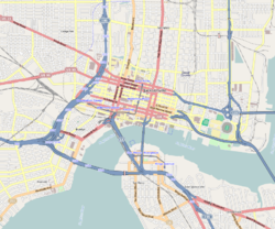
Multiple definitions of Downtown Jacksonville are in common use. Often, the name "Downtown" is used exclusively for the historical core. This is bounded roughly by State Street to the north, Hogans Creek to the east, the St. Johns River to the south, and the LaVilla neighborhood to the west. This definition is used, for example, by the Jacksonville Historic Preservation Commission and their book, Jacksonville's Architectural Heritage. [2] However, the City of Jacksonville and other entities use a wider definition that includes not only the Downtown Core (also known as the Northbank), but surrounding areas on both sides of the river. In this definition, the boundaries are State Street to the north, the St. Johns River to the east, and Interstate 95 to the south and west. [3] This area covers 1,234 acres (499  ha ; 1.928  sq mi ). [4] Downtown Vision, Inc., which oversees Jacksonville's downtown improvement district, covers an even smaller area of about 90 blocks in the Downtown Core and Southbank, bounded by Church Street in the north, Market Street in the east, Prudential Drive in the south, and Broad Street in the west. [3]

Under the broader definition, Downtown Jacksonville is divided into several districts or neighborhood. In addition to the historical Downtown Core, the most commonly used districts are: the Southbank, a commercial and residential district directly across the St. Johns River from the Downtown Core; LaVilla, a historically African-American neighborhood west of the Downtown Core; Brooklyn, to the southwest of the Downtown Core; and the Stadium District, an area containing the city's major sports and entertainment venues to the east of the Downtown Core. [5]

A historic district encompassing a significant portion of downtown Jacksonville was listed on the National Register of Historic Places in 2016. Its boundaries are roughly Beaver Street to the north, Catherine and Liberty Streets to the east, the St. Johns River to the south, and North Pearl Street to the west. This area is significant for its pre-1965 architecture, most of which post-dates Jacksonville's great 1901 fire. [6]

Districts of Downtown Jacksonville

Corner of Laura and Forsyth Streets located in the Northbank Core Lauraforsyth.JPG
Corner of Laura and Forsyth Streets located in the Northbank Core

Central Core

Also known as the Northbank, is Jacksonville's traditional city center and what most people associate with Downtown and Jacksonville in general. It is the location of many government offices, including City Hall, the Jacksonville Sheriff's Office headquarters, and the Bryan Simpson United States Courthouse, and amenities such as the Jacksonville Main Library, the Museum of Contemporary Art Jacksonville, and the Jacksonville Riverwalk. Several of the city's largest skyscrapers are located there, such as the Bank of America Tower, the Wells Fargo Center, TIAA Bank Center, and the SunTrust Tower, and are home to some of the city's major employers, such as TIAA Bank and CSX Corporation.

The Cathedral District

Located in the northeast corner, near Hogans Creek. [7] The 36-block area encompasses 118 acres. It is currently being redeveloped into a leafy, green, vibrant neighborhood where a diverse array of residents can live, work, shop, eat, play and pray. The District extends north to south from State Street to Adams Street and east to west from Main Street to N. Liberty Street. [8] This mixed-used neighborhood is home to many of Jacksonville's landmark churches, including St. John's Episcopal Cathedral, the Mount Zion AME Church, Immaculate Conception Catholic Church, First Presbyterian Church, and the First United Methodist Church. Due to the area's close proximity to the former courthouse many of the residential structures have been converted into attorneys' offices. [9]

The Entertainment & Sports District

also known as the East Bay Street District and other names, exists in the southwest corner of the Downtown Core, centered on East Bay Street. This area was historically industrial before the abandonment of the Jacksonville Shipyards and related industries. [10] Committed to creating an authentic entertainment experience, The Elbow offers a wealth of diverse, walkable and award-winning culinary, nightlife, live music and performance venues. Cultivated around the historic Florida Theatre, The Elbow is one destination that encompasses many diverse restaurants, bars, and breweries. The formal boundaries are Bay Street to Adams Street and Main Street to Liberty Street. [11] The Sports District, also known as the Sports Complex, is located east of the Downtown Core, and contains Jacksonville's major sporting and entertainment venues. Historically part of Jacksonville's Eastside, it is home to TIAA Bank Field, the Baseball Grounds of Jacksonville, VyStar Veterans Memorial Arena, Daily's Place Amphitheater, Metropolitan Park, and the Greater Jacksonville Fair and Expo Center. [12] [13] TIAA Bank Field occupies the footprint of the old Gator Bowl Stadium, which was razed in 1994.

Southbank

Riverplace Tower in Southbank Riverplace Tower, Jacksonville, FL, US.jpg
Riverplace Tower in Southbank

A mixed commercial and residential district on the southern shore of the St. Johns River, directly across from the Northbank. It is closely associated with (and sometimes considered part of) Jacksonville's San Marco neighborhood. It includes large office towers such as the Aetna Building, Riverplace Tower, and Baptist Medical Center. Residential towers include The Peninsula, The Strand, and San Marco Place. There are six major hotels on the Southbank as well as amenities such as the Museum of Science and History, Friendship Fountain and the Southbank Riverwalk. Though historically poorly designed for pedestrians, the city hopes to better integrate it with the rest of Downtown as well as San Marco. [12] [14]

LaVilla

A district immediately west of the Downtown Core. Jacksonville's first suburb, the predominantly African-American neighborhood was an independent municipality until being annexed in 1887. The area of the neighborhood north of Adams Street emerged as a mecca of African-American culture, and was home to many venues showcasing black performers, such as the Ritz Theatre. The southern part of the neighborhood was a major railroad hub and was also Jacksonville's chief red light district for a period. [15]

The neighborhood went into serious decline in the 1960s, and has not recovered. Urban renewal projects commenced in the 1980s, resulting in the loss of many buildings. More recent projects have aimed at bringing commercial development and public amenities to the area. [12] [15] [16] [17]

Brooklyn

Located at the far southwestern corner of downtown, it comprises the area south of Lavilla and north and west of Interstate 95. Originally a residential suburb, it was annexed into Jacksonville in 1887. It is connected to Jacksonville's Riverside neighborhood by Riverside Avenue. It is home to Fidelity National Financial, TIAA Bank, and FIS corporate headquarters, and other offices.

Commercial and industrial uses became prominent in the 20th century, and many commercial office buildings were constructed along the river. Subsequently, a rift emerged between the office-centered part of the neighborhood on the river and the traditional neighborhood further inland. As a result, in the 21st century the city re-introduced residential zoning and the neighborhood has become the site of mixed-use developments. [12] [18] [19] [20]

Adjacent neighborhoods

Architecture

Downtown Northbank Downtown Jacksonville Northbank.JPG
Downtown Northbank
Downtown Southbank JaxFLSouthbank2014.jpg
Downtown Southbank

The 14 tallest standard structures:

Std.
rank
NameYear
Location
(Downtown)
Floors
Standard
height
ft
Std.
hgt
m
Notes
1
Bank of America Tower 1990North Laura Street & West Bay Street42617188 [21] [22]
2
Wells Fargo Center 1974Laura Street & Independent Drive37535163
3
TIAA Bank Center 1983West Bay Street & Pearl Street32447136
4
The Peninsula 20061431 Riverplace Boulevard36437133
5
Riverplace Tower 1967Riverplace Boulevard & Flagler Avenue28432132
6
SunTrust Tower 1989Laura Street & Independent Drive24357109
7
The Strand 20061401 Riverplace Boulevard28328100
8
Eight Forty One 1954841 Prudential Drive2230994
9
Two Prudential Plaza 1985Museum Circle & San Marco Boulevard2130593
10
One Enterprise Center 1986Water & Hogan Streets2129991
11
Blue Cross Blue Shield Building 1971Riverside Avenue & Edison Street1928787
12
BB&T Building 1974West Forsyth & Hogan Streets1827885
13
John Milton Bryan Simpson United States Courthouse 2002West Duval & Hogan Streets1527784
14
JEA Tower 2005West Church & Main Streets1926882

Parks and plazas

Treaty Oak Park Southbank, Jacksonville, FL 32207, USA - panoramio.jpg
Treaty Oak Park

Downtown is home to numerous parks, large and small:

Economy

Museum of Science and History MOSH Exterior .jpg
Museum of Science and History
Prime F. Osborn III Convention Center Jacksonville Terminal Complex, FL, US (16).jpg
Prime F. Osborn III Convention Center
Omni Jacksonville Hotel adjacent to One Enterprise Center OneECenter.jpg
Omni Jacksonville Hotel adjacent to One Enterprise Center

Tourism

The following attractions are located in the downtown Jacksonville area:

The following hotels are located in the downtown Jacksonville area:

Transportation

Downtown Jacksonville transportation options include bus, JTA Skyway, water taxi, as well as major roadways.

Public transportation

Riverplace Station on the Southbank Line of the Jacksonville Skyway JTA Skyway Riverplace Station.JPG
Riverplace Station on the Southbank Line of the Jacksonville Skyway

Downtown is served by the Jacksonville Transportation Authority's zero-fare automated people mover system (known as the "Skyway") and an extensive bus network. [23] The Skyway has the following stations:

Current Skyway Stations [24]

Downtown is also home to Greyhound's Jacksonville bus terminal.

Bridges

Main Street Bridge MSBJaxFL.jpg
Main Street Bridge

Jacksonville is nicknamed "The River City". Historically, life in the city existed around the economic activity along the shores of the St. Johns River. Downtown lies on a portion of river that narrows before it empties out into the Atlantic Ocean. The areas strategic location makes it home to a high concentration of bridges. Just in Downtown, there are 5 bridges (listed below) connecting the two halves of Duval County.

Highways

Major roadways serving Downtown from the suburbs include (I-10) from Baldwin, (I-95) North from the airport area, (I-95) South from St. Augustine, Arlington Expressway from the Beaches, and the Hart Expressway from the Southside area. Other important roadways are U.S. Route 1, U.S. Route 17, and U.S. Route 90. Downtown is also the southern terminus of U.S. Route 23.

See also

Related Research Articles

<span class="mw-page-title-main">Jacksonville, Florida</span> City in Florida, United States

Jacksonville is the most populous city proper in the U.S. state of Florida, located on the Atlantic coast of northeastern Florida. It is the seat of Duval County, with which the City of Jacksonville consolidated in 1968. It is the largest city by area in the contiguous United States as of 2020.

<span class="mw-page-title-main">Jacksonville Skyway</span> People mover in Jacksonville, Florida, United States

The Jacksonville Skyway is an automated people mover in Jacksonville, Florida. It opened in 1989 and is operated by the Jacksonville Transportation Authority (JTA). The skyway has three stations in Downtown Jacksonville and was extended in 1996 following a conversion from its original technology to Bombardier Transportation equipment. It was expanded again in 1998 and 2000. The currently fare-free system comprises two routes across 2.5 miles (4.0 km) of track, serving eight stations, and crosses the St. Johns River on the Acosta Bridge. In 2022, the system had a ridership of 276,600, or about 1,400 per day as of the third quarter of 2023.

<span class="mw-page-title-main">Central station (Jacksonville)</span> Monorail station in Florida, United States

Central station is a Jacksonville Skyway monorail station in Jacksonville, Florida. It is the transfer point for the system's Northbank and Southbank lines. It is located on Bay Street between Pearl and Julia Streets in Downtown Jacksonville.

<span class="mw-page-title-main">San Marco station</span> Jacksonville Skyway station in Florida, US

San Marco station is a Jacksonville Skyway people mover station in Jacksonville, Florida. It is located at the corner of San Marco Boulevard and Mary Street in the Southbank area of Downtown Jacksonville. Nearby points of interest include the Museum of Science and History and Friendship Fountain Park.

<span class="mw-page-title-main">Riverplace station</span> Jacksonville Skyway monorail station in Florida, United States

Riverplace station is a station of the Jacksonville Skyway in Jacksonville, Florida. It is located at the corner of Mary Street and Flagler Avenue in the Southbank area of Downtown Jacksonville. It is near Riverplace Tower.

<span class="mw-page-title-main">Kings Avenue station</span> Jacksonville Skyway monorail station in Florida, United States

Kings Avenue station is a Jacksonville Skyway station in Jacksonville, Florida. It is located on Onyx Street between Prudential Drive and Louisa Street in the Southbank area of Downtown Jacksonville.

<span class="mw-page-title-main">Neighborhoods of Jacksonville</span>

There are more than 500 neighborhoods within the area of Jacksonville, Florida, the largest city in the contiguous United States by area. These include Downtown Jacksonville and surrounding neighborhoods. Additionally, greater Jacksonville is traditionally divided into several major sections with amorphous boundaries: Northside, Westside, Southside, and Arlington, as well as the Jacksonville Beaches.

<span class="mw-page-title-main">Beach Boulevard (Jacksonville)</span>

Beach Boulevard is an east–west road running from Jacksonville, Florida, United States east to Jacksonville Beach. Most of the road is part of U.S. Route 90 and unsigned as State Road 212, and a small portion at the eastern end is unsigned as County Road 212.

<span class="mw-page-title-main">Downtown Tampa</span> Neighborhood in Hillsborough, Florida, United States

Downtown Tampa is the central business district of Tampa, Florida, United States, and the chief financial district of the Tampa Bay Area.

<span class="mw-page-title-main">Riverplace Tower</span> Office building in Jacksonville, FL

The Riverplace Tower is a 28-floor office building on the south bank of the St. Johns River in Jacksonville, Florida. At the time of its construction, it was the tallest building in the state of Florida and was the defining landmark in Jacksonville's skyline. On April 18, 2012, the American Institute of Architects's Florida Chapter placed the building on its list of Florida Architecture: 100 Years. 100 Places as the Riverplace Tower / Formerly Gulf Life Tower.

<span class="mw-page-title-main">Jacksonville Riverwalks</span>

The Jacksonville Riverwalks are a network of multi-use trails and open space developments along both the north and south banks of the St. Johns River in Jacksonville, Florida. The roughly 2-mile (3.2 km) Downtown Northbank portion travels alongside the Hyatt Regency Jacksonville, Jacksonville Landing, Times-Union Center for the Performing Arts, CSX Transportation Building, and extends into the Brooklyn district. The 1.25-mile (2.01 km) Southbank portion of the trail connects local landmarks such as Friendship Fountain, Museum of Science and History and Riverplace Tower.

<span class="mw-page-title-main">Eight Forty One</span> 309 feet (94 metres), 22-floor office building on the south bank of St. Johns River

Eight Forty One is a 309 feet, 22-floor office building on the south bank of St. Johns River in Jacksonville, Florida. Completed in 1955, it was the tallest building in the city for 13 years until surpassed by the Riverplace Tower. It was "The Tallest Office Building in the South" and the tallest in Florida until NASA's Vehicle Assembly Building was completed in 1965. The building's former names include the Aetna Building, Prudential Plaza I or One Prudential Plaza, and the Prudential Building.

<span class="mw-page-title-main">Transportation in Jacksonville, Florida</span> Overview of transportation in Jacksonville, Florida

The Jacksonville transportation network includes ground, air, and sea options for passenger and freight transit. The Jacksonville Port Authority (Jaxport) operates the Port of Jacksonville, which includes container shipping facilities at Blount Island Marine Terminal, the Talleyrand Marine Terminal and the Dames Point Marine Terminal. Jacksonville Aviation Authority managers Jacksonville International Airport in Northside, as well as several smaller airports. The Jacksonville Transportation Authority (JTA) operates bus, people mover, and park-n-ride services throughout the city and region. A major bus terminal at the intermodal Rosa Parks Transit Station serves as JTA's main transit hub. Various intercity bus companies terminate near Central Station. Amtrak operates passenger rail service to and from major cities throughout North America. The city is bisected by major highways, I-95 and I-10, I-295 creates a full beltway around the city.

<span class="mw-page-title-main">Brooklyn (Jacksonville)</span> Neighborhood of Jacksonville, Florida

Brooklyn is a neighborhood of Jacksonville, Florida, considered part of the downtown area. Originally a residential suburb, commercial uses became prominent during the 20th century, particularly along the St. Johns River and Riverside Avenue, and the area became included in Jacksonville's central business district. In the 21st century, it has become the site of mixed-use developments.

<span class="mw-page-title-main">Southbank (Jacksonville)</span> Neighborhood of Jacksonville, Florida

The Southbank is a neighborhood of Jacksonville, Florida, considered part of the Urban Core.

<span class="mw-page-title-main">San Marco (Jacksonville)</span> Neighborhood of Jacksonville, Florida

San Marco is a neighborhood of Jacksonville, Florida, south of Downtown across the St. Johns River. The neighborhood was formerly the independent city of South Jacksonville until it was annexed by Jacksonville in 1932. The neighborhood is primarily residential, with an integrated commercial sector known as San Marco Square.

<span class="mw-page-title-main">Jacksonville Water Taxi</span>

The Jacksonville Water Taxi, or Jacksonville River Taxi, is a water taxi service in Jacksonville, Florida. Established in 1987, it ferries passengers across the St. Johns River between the Northbank and Southbank of Downtown Jacksonville. Stops are located along the Riverwalks. In 2022, the system had a ridership of 415,900, or about 1,700 per day as of the third quarter of 2023.

<span class="mw-page-title-main">Architecture of Jacksonville</span>

The architecture of Jacksonville is a combination of historic and modern styles reflecting the city's early position as a regional center of business. According to the National Trust for Historic Preservation, there are more buildings built before 1967 in Jacksonville than any other city in Florida, though few structures in the city center predate the Great Fire of 1901. Numerous buildings in the city have held state height records, dating as far back as 1902, and last holding a record in 1981.

<span class="mw-page-title-main">Laura Street</span> Street in Jacksonville

Laura Street is a north–south street in Jacksonville, Florida, United States, named for the daughter of the city's founder, Isaiah D. Hart. Historically, the downtown portion of Laura Street has been considered the financial district of Jacksonville.

<span class="mw-page-title-main">Riverside Arts Market</span>

The Riverside Arts Market (RAM) of Jacksonville, Florida is a weekly arts-and-crafts market featuring live music, food, art, and fresh produce. It first opened to the public in the spring of 2009 and currently opens every Saturday 10AM-3PM ET rain or shine, year-round. The marketplace includes a 350-person amphitheater known as Northbank Riverwalk Artists’ Square and forms the terminus for the Northbank Riverwalk. It is located underneath the Fuller Warren Bridge alongside the St. Johns River.

References

  1. "State of Downtown Jacksonville 2015". downtownjacksonville.org. Downtown Vision Inc. Retrieved February 5, 2017.
  2. 1 2 3 4 Wood, Wayne (1992). Jacksonville's Architectural Heritage. University Press of Florida. pp. 22–29. ISBN   0-8130-0953-7.
  3. 1 2 "Who We Are". downtownjacksonville.org. Downtown Vision, Inc. Retrieved December 18, 2012.
  4. "The State of Downtown: 2011 Progress Report". Downtown Vision, Inc. 2011. p. 2. Retrieved December 20, 2012.
  5. "Celebrating the River: A Plan for Downtown Jacksonville". www.coj.net. City of Jacksonville. 2000. Archived from the original (PDF) on August 8, 2013. Retrieved December 20, 2012.
  6. "NRHP nomination for Downtown Jacksonville Historic District" (PDF). National Park Service. Retrieved October 16, 2017.
  7. "Downtown Jacksonville Master Plan". City Of Jacksonville. Retrieved December 14, 2012.
  8. "About". Cathedral District Jacksonville. Retrieved November 28, 2021.
  9. "Exploring Downtown's Cathedral District". Metro Jacksonville. Retrieved December 14, 2012.
  10. "Remembering The East Bay Street District". Metro Jacksonville. Retrieved September 2, 2013.
  11. "The Elbow". Downtown Jacksonville. Retrieved November 28, 2021.
  12. 1 2 3 4 "In the zone: JEDC wants to expand Bay Street entertainment area". Jaxdailyrecord.com. June 8, 2011. Retrieved September 2, 2013.
  13. "Celebrating the River: A Plan for Downtown Jacksonville". www.coj.net. City of Jacksonville. 2000. pp. 31–32. Archived from the original (PDF) on August 8, 2013. Retrieved December 20, 2012.
  14. "Celebrating the River: A Plan for Downtown Jacksonville". www.coj.net. City of Jacksonville. 2000. pp. 34–35. Archived from the original (PDF) on August 8, 2013. Retrieved December 20, 2012.
  15. 1 2 Wood 1992, pp. 86–89
  16. "History of LaVilla" . Retrieved September 16, 2012.
  17. "Celebrating the River: A Plan for Downtown Jacksonville". www.coj.net. City of Jacksonville. 2000. pp. 22–23. Archived from the original (PDF) on August 8, 2013. Retrieved December 20, 2012.
  18. "Celebrating the River: A Plan for Downtown Jacksonville". www.coj.net. City of Jacksonville. 2000. pp. 20–21. Archived from the original (PDF) on August 8, 2013. Retrieved February 21, 2013.
  19. "History of Brooklyn" . Retrieved September 16, 2012.
  20. "Celebrating the River: A Plan for Downtown Jacksonville". www.coj.net. City of Jacksonville. 2000. pp. 2–21. Archived from the original (PDF) on August 8, 2013. Retrieved December 20, 2012.
  21. "Bank of America Tower". skyscraperpage.com. Retrieved December 7, 2008.
  22. "Bank of America Tower, Jacksonville Florida". Portfolio Current Properties. Parameter Realty Partners. Archived from the original on December 9, 2012. Retrieved December 7, 2008.
  23. "Downtown Jacksonville: Skyway" (website). Retrieved September 16, 2012.
  24. "JTA Downtown Map". Archived from the original on October 14, 2012. Retrieved September 16, 2012.

30°19′10″N81°39′36″W / 30.3194°N 81.6600°W / 30.3194; -81.6600