This article needs additional citations for verification .(September 2010) |
Springfield | |
---|---|
Coordinates: 30°20′39.9″N81°39′18.8″W / 30.344417°N 81.655222°W | |
Government | |
• City Council | Reginald Gaffney(D) |
• State Assembly | Tracie Davis(D) |
• State Senate | Audrey Gibson(D) |
• U.S. House | AL Lawson(D) |
Area | |
• Total | 2.53 km2 (0.978 sq mi) |
• Land | 2.53 km2 (0.978 sq mi) |
Population (2008) | |
• Total | 4,674 |
• Density | 1,800/km2 (4,800/sq mi) |
[1] | |
ZIP Code | 32206 |
Area code(s) | 904 |
Website | myspringfield.org |
[1] | |
Springfield Historic District | |
Location | Jacksonville, Florida, US |
Built | 1880s through 1920s |
Architectural style | Late 19th- and 20th-century revivals Prairie School Colonial Revival Queen Anne |
NRHP reference No. | 86003640 [2] |
Added to NRHP | January 22, 1987 |
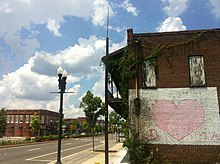
Springfield is a historic neighborhood of Jacksonville, Florida, United States, located to the north of downtown. Established in 1869, it experienced its greatest growth from the early 1880s through the 1920s. The Springfield Historic District is listed in the National Register of Historic Places, and contains some of the city's best examples of 19th and early 20th century architecture.
The boundaries of Springfield are well defined. Hogan's Creek lies along its south edge, and railroad lines are found on the north and east. Boulevard defines the western limit of the district where a later commercial strip abuts the earlier residential area. Contemporary with the overall residential area are two commercial strips along Main and Eighth Streets which join at the heart of the district. The district contains 119 city blocks in an area of approximately 500 acres (2 km2), or slightly less than one square mile. Hogan's Creek separates the residences of Springfield from the downtown business district. North of the creek few buildings rise above two stories and parks and tree lined streets are common.
The blocks of the historic district are laid out in a regular grid, with named streets running north and south and numbered streets east and west. Most of the blocks have alleys, usually arranged in an "H" pattern, although other configurations are found. A few streets retain their original brick pavers and granite curbstones, but the majority are now covered with asphalt and have concrete curbs. Sidewalks feature both the earlier hexagonal pavers and modern poured concrete sections. Trees lend considerable distinction to the neighborhood. Oaks predominate. Scattered throughout the neighborhood are such decorative elements as hitching posts, cast iron fences, rusticated concrete block walls, and carriage stepping stones, testimony to the area's turn-of-the-century origins. There is, however, no great concentration of such elements.
Springfield was established as a residential community in 1871 by developer John H. Norton. [3] Its concentrated physical development began about 1882 with the formation of the Springfield Development Company and accelerated after a fire that destroyed much of downtown Jacksonville in 1901. The Great Fire of 1901 consumed much of central Jacksonville, leaving many of the city's most prominent and wealthy citizens homeless. Smoke from the fire was reportedly so heavy it could be seen as far away as North Carolina. The fire lasted 8 hours and consumed 146 city blocks, 3268 buildings, and killed seven people. After the fire, many of the Jacksonville's residents who lost homes in the fire relocated to Springfield.
Contributing buildings in the district date from about 1885 to approximately 1930. The majority of the houses are wood frame vernacular structures, but there are some examples of late 19th century revival and romantic styles, including Queen Anne, Colonial Revival, and the Stick style. 20th century types include Prairie School, Bungalow, and Mediterranean. The neighborhood did not experience a resurgence of construction during the 1920s, as did other residential sections of the city, and the "boom" bypassed the area since much of the land was already occupied, except in the area north of Eighth Street. Construction was, therefore, limited to the occasional vacant lot or those sites where older structures had been lost or required replacement.
At the time the district was listed in the National Register, it contained 1,784 buildings fifty years old or older that contributed to its historical character. Of that number, 1,686 were classified as residential. Only 48 were commercial. The great majority of buildings, 1,595, were wood frame, and 201 were masonry. There were 1,294 buildings of two stories in height and 10 three-story structures. The remainder were all one-story structures.
The January 2010 issue of Southern Living magazine spotlights Springfield as the #1 "comeback" neighborhood in the South, noting significant improvement over the past decade. [4] The December 2010 issue of Florida Trend Magazine also featured the Springfield Historic District in an article titled "A Life of Its Own". The piece detailed how, despite the down housing market, the neighborhood has continued to thrive.
Recently, the neighborhood has experienced renewed interest from developers; two brewery projects have been announced for the area, as well as two restaurants and a Walgreens community pharmacy, in 2016 alone. [5]
The Hogan's Creek Park System is one of the most notable features of Springfield. These historic parks and structures which define the southern boundary of the neighborhood constitute 30.91 acres (125,100 m2) of Springfield or approximately five percent of the total land area. Klutho Park comprises 17.47 acres (70,700 m2) and Springfield Park another 8.3 acres (34,000 m2). Along the creek itself are the balustrades and bridges designed by Henry John Klutho in 1929. Klutho was Jacksonville's most influential architect during the first years of the twentieth century and its leading proponent of the Prairie School. The house he designed for himself in Springfield was said to be the first in Florida to draw on the "modernist" architectural movements in America.
Springfield is composed mainly of wood frame residential buildings and a much smaller number of masonry commercial, religious, educational, and civic structures. There were 1,038 frame vernacular buildings in the historic district that possessed no discernible stylistic features, though in certain cases the decorative details may have been removed in later remodeling. Most of these vernacular buildings are two stories in height with a gable or hip roof. The wood-frame buildings that retain their original fabric are generally clad with weatherboard or novelty siding or, in a few cases, wood shingles. In many cases, aluminum, vinyl, or asbestos siding have been applied to the exterior of houses. One-story porches and verandas are common, and there are some porches with upper galleries. There are a variety of sash and casement window types. Masonry vernacular buildings are generally brick or stuccoed and are either one or two stories in height. Most of these are commercial buildings with fixed glass storefronts. Few exhibit any ornamentation. Their roofs are usually the flat built-up variety with parapets on the street facade.
Some additional commercial and industrial buildings are found along the northern and eastern boundaries of the district in conjunction with the railroad lines, and isolated commercial structures are found within the neighborhood. Schools, churches, multi-family residences and parks are found throughout the neighborhood. Although there are a number of modern intrusions along Springfield's main commercial arteries, these have not proved so numerous as to be overwhelming. Also, except for demolitions, the residential area remains largely unchanged, with relatively little post-1930 construction. Contributing buildings were all fifty years old or older and retained enough of their original physical character to adequately embody the sense of time, place, and historic association normally required in establishing a historic district. These comprised 95 percent of all of the buildings in the district. The non-contributing buildings were either less than fifty years old and lacked exceptional significance or were more than fifty years old but retained little, if any, of their original physical integrity. These numbered five percent of the total.
The Great Fire of 1901 was a conflagration that occurred in Jacksonville, Florida on Friday, May 3, 1901. It was one of the worst disasters in Florida history and the third largest urban fire in the U.S., next to the Great Chicago Fire, and the 1906 San Francisco fire.
Downtown Jacksonville is the historic core and central business district (CBD) of Jacksonville, Florida USA. It comprises the earliest area of the city to be developed and is located in its geographic center along the narrowing point of the St. Johns River. There are various definitions of what constitutes Jacksonville's downtown; the one used by the city government and other entities defines it as including eight districts: the Central Core, the Southbank, LaVilla, Brooklyn, the Working Waterfront, the Cathedral, the Church, and the Entertainment & Sports District. The area features offices for major corporations such as CSX Corporation, Fidelity National Financial, TIAA Bank, Black Knight Financial, One Call Care Management, Suddath, Interline Brands Haskell, FIS, and Stein Mart.
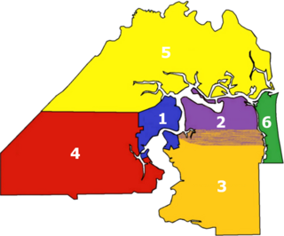
There are more than 500 neighborhoods within the area of Jacksonville, Florida, the largest city in the contiguous United States by area. These include Downtown Jacksonville and surrounding neighborhoods. Additionally, greater Jacksonville is traditionally divided into several major sections with amorphous boundaries: Northside, Westside, Southside, and Arlington, as well as the Jacksonville Beaches.
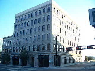
The Dyal–Upchurch Building is a six-story, 43,747-square-foot historic building in Jacksonville, Florida. It is located at 4 East Bay Street, and was designed by architect Henry John Klutho. On April 17, 1980, it was added to the U.S. National Register of Historic Places.
The St. James Building is a historic building in Downtown Jacksonville, Florida, currently housing Jacksonville City Hall. It was designed by architect Henry John Klutho and opened in 1912. One of many structures in downtown Jacksonville designed by Klutho after the Great Fire of 1901, it is considered his Prairie School masterpiece.
Henry John Klutho (1873–1964) was an American architect known for his work in the "Prairie School" style. He helped in the reconstruction of Jacksonville, Florida after the Great Fire of 1901—the largest-ever urban fire in the Southeast—by designing many of the new buildings built after the disaster. This period lasted until the beginning of World War I. Several Jacksonville architects began their careers in the offices of Klutho's firm.
The Lummus Park Historic District or simply Lummus Park, is on the National Register of Historic Places and a locally historic designated district in Miami, Florida. It is roughly bound by Northwest Fifth Street to the north, Flagler Street to the south, Northwest Third Avenue to the east, and the Miami River to the west. On October 25, 2006, it was added to the U.S. National Register of Historic Places. Lummus Park has some of the oldest structures in Miami, and over the decades, has been able to retain a large part of its early pioneer character.
The Karpeles Manuscript Library Museum is a museum in Jacksonville, Florida, one of fifteen Karpeles Manuscript Library Museums in the United States, all housed in repurposed old buildings. Other locations of Karpeles Museums include Buffalo, NY; Charleston, SC; Duluth, MI; Newburgh, NY; Santa Barbara, CA; Tacoma, WA; Shreveport, LA; Fort Wayne, IN; Alvin, TX; Rock Island, IL; St. Louis, MO; Gloversville, NY; Pittsburgh, PA; and Great Falls, MT. Karpeles Manuscript Library Museums display manuscripts and documents from the private collection of David and Marsha Karpeles, the world's largest such collection, as well as art exhibits.
The Bridge Avenue Historic District is located in a residential neighborhood on the east side of Davenport, Iowa, United States. It has been listed on the National Register of Historic Places since 1983. The historic district stretches from River Drive along the Mississippi River up a bluff to East Ninth Street, which is near the top of the hill.
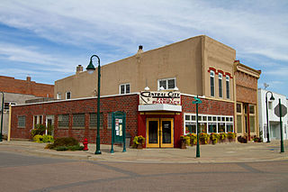
The Central City Commercial Historic District is a nationally recognized historic district located in Central City, Iowa, United States. It was listed on the National Register of Historic Places in 2003. At the time of its nomination it consisted of 27 resources, which included 18 contributing buildings, one contributing object, and eight non-contributing buildings. The historic district exemplifies the importance transportation played in the development of the central business district.
Riverside and Avondale are two adjacent and closely associated neighborhoods, alternatively considered one continuous neighborhood, of Jacksonville, Florida. The area is primarily residential, but includes some commercial districts, including Five Points, the King Street District, and the Shoppes of Avondale.
Henry J. Klutho Park is an 18.34-acre (74,200 m2) public park, located between downtown Jacksonville, Florida and the historic neighborhood of Springfield. It is part of a network of parks that parallel Hogans Creek, Klutho Park being the largest. Klutho Park is home to an 18-hole disc golf course.
The South Bottoms Historic District is a residential neighborhood of Lincoln, Nebraska. The district includes 1050 contributing structures, with a relatively small proportion of 148 non-contributing structures. The neighborhood was settled primarily by Volga Germans in the late 19th and early 20th centuries. The houses are primarily wood-framed single-family residences, with some commercial structures on F Street between 2nd and 5th Streets. The houses mix vernacular American house construction with wood frame traditions brought from Russia by the residents. The neighborhood is roughly bounded by A and M Streets from Eighth Street to the city limits.
The Canal Street–Clark Street Neighborhood Historic District encompasses a compact 19th-century working-class neighborhood of Brattleboro, Vermont. Most of its buildings are modest vernacular wood-frame buildings, erected between 1830 and 1935; there are a few apartment blocks, and one church. The district was listed on the National Register of Historic Places in 1993.
The architecture of Jacksonville is a combination of historic and modern styles reflecting the city's early position as a regional center of business. According to the National Trust for Historic Preservation, there are more buildings built before 1967 in Jacksonville than any other city in Florida, but it is also important to note that few structures in the city center predate the Great Fire of 1901. Numerous buildings in the city have held state height records, dating as far back as 1902, and last holding a record in 1981.
Laura Street is a north–south street in Jacksonville, Florida, United States, named for the daughter of the city's founder, Isaiah D. Hart. Historically, the downtown portion of Laura Street has been considered the financial district of Jacksonville.
The Richmond Hotel is a historic building located in the LaVilla neighborhood of Jacksonville, Florida. The building was originally built in 1909 as a hotel for Black patrons. Following desegregation, the hotel closed in 1969. As of 2018, the ground-level area of the Richmond Hotel is occupied by Delo Studios.
The North Milford Village Historic District is a historic district located in Milford, Michigan, including the commercial area along Main Street from the Huron River to Summit, industrial areas around the mill ponds west of Main, and residential areas east of Main. The district was listed on the National Register of Historic Places in 2000.
The Hegel Road Historic District is a mixed commercial and residential historic district located along Hegel Road between Seneca and the Goodrich Millpond in Goodrich, Michigan. It was listed on the National Register of Historic Places in 1982.
The Homer Village Historic District is a commercial and residential historic district roughly bounded by Leigh, Burgess, Hamilton, School, and Byron Streets in Homer, Michigan. It was listed on the National Register of Historic Places in 1996.