Springlake, Texas

Last updated

Springlake, Texas
Silos in Springlake, TX IMG 4806.JPG
Grain silos in Springlake, Texas
TXMap-doton-Springlake.PNG
Location of Springlake, Texas
Lamb County Springlake.svg
Coordinates: 34°13′52″N102°18′17″W / 34.23111°N 102.30472°W / 34.23111; -102.30472
Country United States
State Texas
County Lamb
Area
[1]
  Total1.03 sq mi (2.66 km2)
  Land1.03 sq mi (2.66 km2)
  Water0.00 sq mi (0.00 km2)
Elevation
3,681 ft (1,122 m)
Population
 (2010)
  Total108
  Estimate 
(2019) [2]
102
  Density99.22/sq mi (38.31/km2)
Time zone UTC-6 (Central (CST))
  Summer (DST) UTC-5 (CDT)
ZIP code
79082
Area code 806
FIPS code 48-69764 [3]
GNIS feature ID1369043 [4]
Cattle herds on irrigated land north of Springlake Cattle north of Springlake, TX IMG 4810.JPG
Cattle herds on irrigated land north of Springlake
Abandoned buildings, such as this one, are common in rural areas like Springlake where there has been a population drain over past decades. Abandoned building, Springlake, TX IMG 4807.JPG
Abandoned buildings, such as this one, are common in rural areas like Springlake where there has been a population drain over past decades.

Springlake is a town in Lamb County, Texas, United States. The population was 108 at the 2010 census. [5] The community is known for its agricultural processing and its yearly Independence Day parade and celebration culminating in a fireworks display headed by the Springlake Volunteer Fire Department. This celebration usually draws several thousand participants who come together to enjoy free food, a free live band, a bake auction, and fellowship.

Contents

It was the hometown of the late Speaker of the Texas House of Representatives, Bill W. Clayton.

Geography

Springlake is located at 34°13′52″N102°18′17″W / 34.23111°N 102.30472°W / 34.23111; -102.30472 (34.231217, –102.304707). [6]

According to the United States Census Bureau, the town has a total area of 1.0 square mile (2.6 km2), all of it land.

Demographics

Historical population
CensusPop.Note
1960 245
1970 209−14.7%
1980 2226.2%
1990 132−40.5%
2000 1352.3%
2010 108−20.0%
2019 (est.)102 [2] −5.6%
U.S. Decennial Census [7]

As of the census [3] of 2000, there were 135 people, 54 households, and 38 families residing in the town. The population density was 132.6 inhabitants per square mile (51.2/km2). There were 68 housing units at an average density of 66.8 per square mile (25.8/km2). The racial makeup of the town was 80.00% White, 0.74% African American, 19.26% from other races. Hispanic or Latino of any race were 33.33% of the population.

There were 54 households, out of which 33.3% had children under the age of 18 living with them, 63.0% were married couples living together, 5.6% had a female householder with no husband present, and 29.6% were non-families. 25.9% of all households were made up of individuals, and 7.4% had someone living alone who was 65 years of age or older. The average household size was 2.50 and the average family size was 3.08.

In the town, the population was spread out, with 30.4% under the age of 18, 4.4% from 18 to 24, 28.1% from 25 to 44, 23.0% from 45 to 64, and 14.1% who were 65 years of age or older. The median age was 38 years. For every 100 females, there were 101.5 males. For every 100 females age 18 and over, there were 100.0 males.

The median income for a household in the town was $20,000, and the median income for a family was $20,625. Males had a median income of $31,875 versus $13,125 for females. The per capita income for the town was $7,841. There were 34.3% of families and 42.0% of the population living below the poverty line, including 51.9% of under eighteens and 35.7% of those over 64.

Education

The Town of Springlake is served by the Springlake-Earth Independent School District.

See also

Related Research Articles

<span class="mw-page-title-main">Lamb County, Texas</span> County in Texas, United States

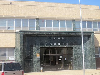
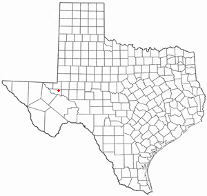
Lamb County is a county located in the U.S. state of Texas. As of the 2020 census, its population was 13,045. Its county seat is Littlefield. The county was created in 1876, but not organized until 1908. It is named for George A. Lamb, who died in the Battle of San Jacinto.

<span class="mw-page-title-main">Castro County, Texas</span> County in Texas, United States

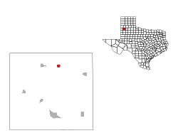
Castro County is a county located in the U.S. state of Texas. As of the 2020 census, its population was 7,371. Its county seat is Dimmitt. The county was named for Henri Castro, who was consul general to France for the Republic of Texas and the founder of a colony in Texas.

<span class="mw-page-title-main">Ash Flat, Arkansas</span> City in Arkansas, United States

Ash Flat is a city in Fulton and Sharp counties in the U.S. state of Arkansas with a population of 1,109 in 2021.

<span class="mw-page-title-main">Potts Camp, Mississippi</span> Town in Mississippi, United States

Potts Camp is a town in Marshall County, Mississippi, United States. The population was 523 at the 2010 census.

<span class="mw-page-title-main">Kelly, North Carolina</span> Census-designated place in North Carolina, United States

Kelly is a census-designated place (CDP) in Bladen County, North Carolina, United States. The population was 544 at the 2010 census.

Varnamtown is a town in Brunswick County, North Carolina, United States situated on the banks of the Lockwood Folly River. The population was 541 at the 2010 census. It is part of the Myrtle Beach metropolitan area.

Sandyfield is a town in Columbus County, North Carolina, United States. The population was 447 at the 2010 census.

<span class="mw-page-title-main">Rochester, Ohio</span> Village in Ohio

Rochester is a village in Lorain County, Ohio, United States, along the West Branch of the Black River. The population was 159 at the 2020 census.

<span class="mw-page-title-main">Morris Township, Greene County, Pennsylvania</span> Township in Pennsylvania, United States

Morris Township is a township that is located in Greene County, Pennsylvania, United States. The population was 566 at the time of the 2020 census, a decline from the total of 818 that was tabulated during the 2010 census.

<span class="mw-page-title-main">Silverton, Texas</span> City in Texas, United States

Silverton is a city in Briscoe County, Texas, United States. The population was 731 at the 2010 census. It is the county seat of Briscoe County.

<span class="mw-page-title-main">Dimmitt, Texas</span> City in Texas, United States

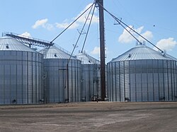
Dimmitt is a city and county seat in Castro County, Texas, United States. Its population was 4,393 at the 2010 census.

<span class="mw-page-title-main">Peñitas, Texas</span> City in Texas, United States

Peñitas is a U.S. city in Hidalgo County, Texas. The population was 6,103 at the 2020 census, up from 1,167 at the 2000 census. It is part of the McAllen–Edinburg–Mission and Reynosa–McAllen metropolitan areas.

<span class="mw-page-title-main">Coahoma, Texas</span> Town in Texas, United States

Coahoma is a town in Howard County, Texas, United States. The population was 817 at the 2010 census, down from 932 at the 2000 census.

<span class="mw-page-title-main">Earth, Texas</span> City in Texas, United States

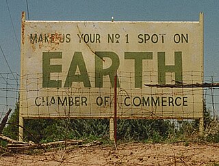
Earth is a small, rural city in Lamb County, West Texas, United States. As of the 2010 Census, the population was 1,065.

<span class="mw-page-title-main">Emhouse, Texas</span> Town in Texas, United States

Emhouse is a town in Navarro County, Texas, United States. The population was 133 at the 2010 census.

<span class="mw-page-title-main">Meadow, Texas</span> Town in Texas, United States

Meadow is a town in Terry County, Texas, United States. The population was 593 at the 2010 census.

<span class="mw-page-title-main">Grandfalls, Texas</span> Town in Texas, United States

Grandfalls is a town in Ward County, Texas, United States. It was named for its location near the "grand falls" of the Pecos River, located roughly 3 miles (4.8 km) to the west. Early settlers were attracted to the Grandfalls area in the late 1880s by the steady supply of water flowing in the Pecos River. Its population was 360 at the 2010 census.

<span class="mw-page-title-main">Thorntonville, Texas</span> Town in Texas, United States

Thorntonville is a town in Ward County, Texas, United States. The population was 476 according to the 2010 census.

<span class="mw-page-title-main">Plains, Texas</span> Town in Texas, United States

Plains is a town and the county seat of Yoakum County of western Texas, United States, particularly the south (inner) half of the panhandle's plains. The city's population was 1,481 at the 2010 census. Plains in the Texas High Plains Wine country.

<span class="mw-page-title-main">Keller, Virginia</span> Town in Virginia, United States

Keller is a town in Accomack County, Virginia, United States. The population was 178 at the 2010 census.

References

  1. "2019 U.S. Gazetteer Files". United States Census Bureau. Retrieved August 7, 2020.
  2. 1 2 "Population and Housing Unit Estimates". United States Census Bureau. May 24, 2020. Retrieved May 27, 2020.
  3. 1 2 "U.S. Census website". United States Census Bureau . Retrieved January 31, 2008.
  4. "US Board on Geographic Names". United States Geological Survey. October 25, 2007. Retrieved January 31, 2008.
  5. "Profile of General Population and Housing Characteristics: 2010 Demographic Profile Data (DP-1): Springlake town, Texas". United States Census Bureau . Retrieved January 26, 2012.
  6. "US Gazetteer files: 2010, 2000, and 1990". United States Census Bureau. February 12, 2011. Retrieved April 23, 2011.
  7. "Census of Population and Housing". Census.gov. Retrieved June 4, 2015.