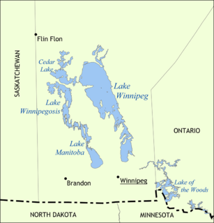
Lake Manitoba is the 14th largest lake in Canada and the 33rd largest lake in the world with a total area of 4,624 km2 (1,785 sq mi). It is located within the Canadian province of Manitoba about 75 km (47 mi) northwest of the province's capital, Winnipeg, at 50°59′N98°48′W.

Portage la Prairie is a small city in the Central Plains Region of Manitoba, Canada. As of 2016, the population was 13,304 and the land area of the city was 24.68 square kilometres (9.53 sq mi).

Turtle Mountain Provincial Park is a provincial park located in the southwestern portion of the Canadian province of Manitoba. Within it are the Adam Lake and Max Lake campgrounds. The park is known for its bike trails, fishing, back country cabins and canoe routes. The park is very popular with families and outdoor enthusiasts.
Riding Mountain National Park is a national park in Manitoba, Canada. The park is located within Treaty 2 Territory and sits atop the Manitoba Escarpment. Consisting of a protected area 2,969 km2 (1,146 sq mi), the forested parkland stands in sharp contrast to the surrounding prairie farmland. It was designated a national park because it protects three different ecosystems that converge in the area; grasslands, upland boreal and eastern deciduous forests. It is most easily reached by Highway 10 which passes through the park. The south entrance is at the townsite of Wasagaming, which is the only commercial centre within the park boundaries.
Asessippi Provincial Park is a provincial park in the Rural Municipality of Riding Mountain West, Manitoba, Canada.

Hecla-Grindstone Provincial Park is a provincial park in Manitoba, Canada, which includes Hecla Island, Grindstone, Black Island and a number of other small islands in Lake Winnipeg, one of the largest freshwater lakes in the world. The park lies adjacent to the northeast side of the Municipality of Bifrost – Riverton in Manitoba.
Birds Hill Provincial Park is a provincial park in Manitoba, Canada located in the Boreal Plains ecozone. The park protects areas representative of Aspen/Oak parkland, as well as provides opportunities for recreation. It is located 24 kilometers north of Winnipeg on Highway 59, and covers approximately 8,300 acres or 35.1 km2.
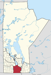
The Central Plains Region is an informal geographic region of the Canadian province of Manitoba located in the south central part of the Canadian province of Manitoba, directly west of Winnipeg.

Whiteshell Provincial Park is a provincial park in southeast Manitoba, approximately 120 kilometres (75 mi) east of the city of Winnipeg. The park is considered to be a Class II protected area under the IUCN protected area management categories. It is 275,210 hectares in size.

Grand Beach Provincial Park is a provincial park in Manitoba, Canada, noted for its large white sand dunes and ancient beaches from the end of the last ice age. It is located on the eastern shore of Lake Winnipeg, one of the largest freshwater lakes in the world, and the largest lake completely within the borders of southern Canada.
Southern Manitoba is the southernmost area of the Canadian province of Manitoba. Southern Manitoba encompasses the Winnipeg Metropolitan Region, Westman Region, Central Plains Region, Eastman Region, and Pembina Valley Region, as well as the Manitoba portion of Red River Valley. Holding a population of over one million, seven of the ten cities in Manitoba are located in this area, including Winnipeg, Brandon, Portage la Prairie, Selkirk, Morden, Winkler, and Steinbach.
Duck Mountain Provincial Park is a provincial park, located in the Canadian province of Saskatchewan 14 km east of the town of Kamsack and stretches about 12 kilometres eastward to the Saskatchewan / Manitoba boundary. The park covers approximately 150 square kilometres. Road access to the park is via Highway 57, which connects Saskatchewan Highway 5 to Manitoba Highway 83.

Buffalo Pound Provincial Park is a provincial park located in southern Saskatchewan, Canada, about 30 km (19 mi) north-east of downtown Moose Jaw and 86 km (53 mi) north-west of the city of Regina.

Meadow Lake Provincial Park is a northern boreal forest provincial recreational park along the Waterhen and Cold Rivers in the Canadian province of Saskatchewan. The park was founded on 10 March 1959, is the largest provincial park in Saskatchewan, and encompasses over 25 lakes in an area of 1,600 square kilometres. The park was named Meadow Lake after the city of Meadow Lake and Meadow Lake. The city and the lake are not in the park and are located about 40 kilometres (25 mi) south-east of the nearest park entrance, which is about 5 kilometres (3.1 mi) north of Dorintosh. The length of the park stretches about 113 kilometres (70 mi) from Cold Lake on the Saskatchewan / Alberta border in the west to the eastern shore of Waterhen Lake in the east.
Narrow Hills Provincial Park is a northern boreal forest provincial recreational park in the Canadian province of Saskatchewan. It is located in a hilly plateau called the Cub Hills and contains several recreational facilities and over 25 accessible lakes within its boundaries. The geographical features of the park, including the lakes, valleys, and lowlands were formed over 10,000 years ago during the last ice age. The town of Smeaton is the closest community and it is located 70 kilometres (43 mi) to the south.

Beaudry Provincial Park is an approximately 953.4-hectare (2,356-acre) park located along the Assiniboine River west of the town of Headingley, Manitoba.

Lundar Beach Provincial Park is a provincial park on the east shore of Lake Manitoba in Manitoba, Canada. It is located in the Rural Municipality of Coldwell, 18 kilometres west of Lundar, Manitoba.
William Lake Provincial Park is a provincial park located in the Rural Municipality of Morton, in southwest Manitoba on Turtle Mountain. Its sister park, the much larger Turtle Mountain Provincial Park, lies to the west.
Porcupine Hills Provincial Park is the newest provincial park in the Canadian Province of Saskatchewan. It was created in 2018 through the amalgamation of five pre-existing provincial recreation sites south-east of the town of Hudson Bay. The park is in the Porcupine Provincial Forest in the Porcupine Hills, which is a geographical feature in eastern Saskatchewan and western Manitoba. The hills are part of a range of hills called the Manitoba Escarpment.
Makwa Lake Provincial Park is a recreational provincial park in the west-central region of the Canadian province of Saskatchewan in the transition zone between parkland and boreal forest. The park was established in 1986 and is centred around the lakes of Big Jumbo, Little Jumbo, and Makwa. Prior to its establishment, the park was a provincial recreation site. The main entrance to Makwa Lake Park is at the south-east corner of Makwa Lake about 3 km (1.9 mi) west of the village of Loon Lake. Access is from Highway 699.
