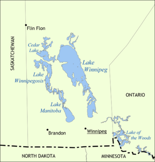
Lake Winnipeg is a very large, relatively shallow 24,514-square-kilometre (9,465 sq mi) lake in North America, in the province of Manitoba, Canada. Its southern end is about 55 kilometres (34 mi) north of the city of Winnipeg. Lake Winnipeg is Canada's sixth-largest freshwater lake and the third-largest freshwater lake contained entirely within Canada, but it is relatively shallow excluding a narrow 36 m (118 ft) deep channel between the northern and southern basins. It is the eleventh-largest freshwater lake on Earth. The lake's east side has pristine boreal forests and rivers that were in 2018 inscribed as Pimachiowin Aki, a UNESCO World Heritage Site. The lake is 416 km (258 mi) from north to south, with remote sandy beaches, large limestone cliffs, and many bat caves in some areas. Manitoba Hydro uses the lake as one of the largest reservoirs in the world. There are many islands, most of them undeveloped.

Northern Manitoba is a geographic and cultural region of the Canadian province of Manitoba. Originally encompassing a small square around the Red River Colony, the province was extended north to the 60th parallel in 1912. The region's specific boundaries vary, as "northern" communities are considered to share certain social and geographic characteristics, regardless of latitude.
Birds Hill Provincial Park is a provincial park in Manitoba, Canada located in the Boreal Plains ecozone. The park protects areas representative of Aspen/Oak parkland, as well as provides opportunities for recreation. It is located 24 kilometers north of Winnipeg on Highway 59, and covers approximately 8,300 acres or 35.1 km2.

Grand Rapids is a town in Manitoba, Canada, on the northwestern shore of Lake Winnipeg where the Saskatchewan River enters the lake. As the name implies, the river had a significant drop at this point. In modern days, a large hydroelectric plant has been built there. Cedar Lake, a short distance upriver, provides a natural water source for the plant. Provincial Trunk Highway 6, the region's primary roadway, crosses the Saskatchewan River at the Grand Rapids Bridge.

The Whiteshell River is one of the major rivers in Whiteshell Provincial Park, in southeastern Manitoba, Canada, near the Ontario border. This river is close to some petroform sites that are about 2000 years old or older. The name "whiteshell" is in reference to the Meegis or cowry shells used by Ojibwa peoples in their ceremonies and teachings, especially the Midewiwin, and as recorded in their birch bark scrolls.

Grand Beach Provincial Park is a provincial park in Manitoba, Canada, noted for its large white sand dunes and ancient beaches from the end of the last ice age. It is located on the eastern shore of Lake Winnipeg, one of the largest freshwater lakes in the world, and the largest lake completely within the borders of southern Canada.

Nopiming Provincial Park is a natural provincial park in Manitoba, Canada, located on the southeast side of the province, along the boundary with Ontario.
Atikaki Provincial Park is a wilderness park in Manitoba, Canada, located east of Lake Winnipeg along the Ontario boundary in the Canadian Shield. The area of Atikaki Provincial Park is 3,981 square kilometres (1,537 sq mi). Atikaki Provincial Park is north of Nopiming Provincial Park and borders the Woodland Caribou Provincial Park in Ontario.

Beaudry Provincial Park is an approximately 953.4-hectare (2,356-acre) park located along the Assiniboine River west of the town of Headingley, Manitoba.
Cumberland House Provincial Park is a located at Cumberland House in the Canadian province of Saskatchewan on the site of the first inland Hudson's Bay Company post in Saskatchewan and the oldest village in the province. A powder magazine shed built in 1886 and artifacts from the HBC Northcote steamship are the remaining historic elements on the site.

The Mistik Creek is a stream in the Hudson Bay drainage basin in the Northern Region of Manitoba, Canada, approximately 20 kilometres (12 mi) northeast of Bakers Narrows.

Pinawa Dam Provincial Park is a provincial park located north of Pinawa, Manitoba, on Hwy 520, overlooking the Pinawa Channel.
Birch Island Provincial Park is a remote provincial park located on Lake Winnipegosis in Manitoba, Canada. The park is bordered on its western boundary by the Swan-Pelican Provincial Forest and on its eastern side by Chitek Lake Anishinaabe Provincial Park.

Whitemouth Falls Provincial Park is a provincial park located where the Whitemouth River joins the Winnipeg River in Manitoba, Canada. It was designated as a Provincial Park in 1974.
Zed Lake Provincial Park is a provincial park in Manitoba, Canada, established in 1961. It is 12.07 ha in size. The park is located on the east shore of the eponymous lake, about 27 kilometres (17 mi) north of Lynn Lake on PTR 394. The park has 25 cottage lots, a campground, a boat launch and a beach.
Hnausa Beach Provincial Park is a Manitoba provincial park on the west shore of Lake Winnipeg north of Gimli, Manitoba. The beach within the park is named after the nearby community of Hnausa. Hnausa is an Old Icelandic word for a piece of turf. This part of Manitoba is known as New Iceland due to the significant Icelandic settlement of the area that began in 1875.
Manipogo Provincial Park is a provincial park on the shore of Lake Manitoba, approximately 50 km (31 mi), northeast of Dauphin, Manitoba. It is named after Manipogo, a lake monster reputed to live in the lake.

Netley Creek Provincial Park is a Manitoba provincial park on the west shore of the Red River north of Selkirk, Manitoba at the mouth of Netley Creek. It provides visitors with access to these waterways and adjacent Netley-Libau Marsh.


