
The Red River, also called the Red River of the North to differentiate it from the Red River in the south of the continent, is a river in the north-central United States and central Canada. Originating at the confluence of the Bois de Sioux and Otter Tail rivers between the U.S. states of Minnesota and North Dakota, it flows northward through the Red River Valley, forming most of the border of Minnesota and North Dakota and continuing into Manitoba. It empties into Lake Winnipeg, whose waters join the Nelson River and ultimately flow into Hudson Bay.

Lake Winnipeg is a very large, relatively shallow 24,514-square-kilometre (9,465 sq mi) lake in North America, in the province of Manitoba, Canada. Its southern end is about 55 kilometres (34 mi) north of the city of Winnipeg. Lake Winnipeg is Canada's sixth-largest freshwater lake and the third-largest freshwater lake contained entirely within Canada, but it is relatively shallow excluding a narrow 36 m (118 ft) deep channel between the northern and southern basins. It is the eleventh-largest freshwater lake on Earth. The lake's east side has pristine boreal forests and rivers that were in 2018 inscribed as Pimachiowin Aki, a UNESCO World Heritage Site. The lake is 416 km (258 mi) from north to south, with remote sandy beaches, large limestone cliffs, and many bat caves in some areas. Manitoba Hydro uses the lake as one of the largest reservoirs in the world. There are many islands, most of them undeveloped.

Turtle Mountain Provincial Park is a provincial park located in the southwestern portion of the Canadian province of Manitoba. Within it are the Adam Lake and Max Lake campgrounds. The park is known for its bike trails, fishing, back country cabins and canoe routes. The park is very popular with families and outdoor enthusiasts.

Hecla-Grindstone Provincial Park is a provincial park in Manitoba, Canada, which includes Hecla Island, Grindstone, Black Island, and several other small islands in Lake Winnipeg, one of the largest freshwater lakes in the world. The park lies adjacent to the northeast side of the Municipality of Bifrost – Riverton in Manitoba.
Birds Hill Provincial Park is a provincial park in Manitoba, Canada located in the Boreal Plains ecozone. The park protects areas representative of Aspen/Oak parkland, as well as provides opportunities for recreation. It is located 24 kilometers north of Winnipeg on Highway 59, and covers approximately 8,300 acres or 35.1 km2.
Provincial Trunk Highway 8 is a provincial primary highway located in the Canadian province of Manitoba. It runs from the north limit of the City of Winnipeg, where it meets with Route 180, north to Hecla-Grindstone Provincial Park. The highway between Winnipeg and PR 230 is known as McPhillips Street. At PR 230, McPhillips Street becomes McPhillips Road and continues along PR 230 to PTH 9. The route is a major road connecting Winnipeg with the communities of Winnipeg Beach and Gimli. The speed limit is 100 km/h (60 mph).

The Interlake Region is an informal geographic region of the Canadian province of Manitoba that lies roughly between Lake Winnipeg and Lake Manitoba in the Canadian province of Manitoba.

Winnipeg Beach is a town in the Interlake Region, in the Canadian province of Manitoba. The town was founded in 1900 by Sir William Whyte and is located at the junction of Highway 9 and Highway 229 on the southwestern shore of Lake Winnipeg, about 56 kilometres (35 mi) north of Winnipeg. It is bordered by the Rural Municipality of Gimli, the Rural Municipality of St. Andrews, and Dunnottar as well as Lake Winnipeg. Nearby towns are Ponemah, Whytewold, and Matlock, Gimli, and Sandy Hook,, as well as Teulon, and Selkirk. Its permanent population is 1,439

St. Clements is a rural municipality (RM) in Manitoba, Canada. It is located to the north-east of Winnipeg, stretching from East St. Paul and Birds Hill Provincial Park in the south to Lake Winnipeg and Grand Beach Provincial Park to the north. The Red River demarcates the western boundary of the municipality. St. Clements contains the communities of East Selkirk, and Lockport east of the Red River. It almost completely surrounds the Brokenhead 4 Indian reserve, with the exception of a small lakefront on Lake Winnipeg.

Whiteshell Provincial Park is a provincial park in southeast Manitoba, approximately 120 kilometres (75 mi) east of the city of Winnipeg. The park is considered to be a Class II protected area under the IUCN protected area management categories. It is 275,210 hectares in size.
Beaver Creek Provincial Park is a provincial park on Lake Winnipeg near the mouth of Beaver Creek in the North Interlake Region of Manitoba, Canada.
Woodlands is a rural municipality (RM) in the province of Manitoba in Western Canada. It lies in the southern part of the Interlake and is named for the community of Woodlands, which itself is named for the wooded lands of the area.
Elk Island Provincial Park is a provincial park in Manitoba, Canada. The park is 10.7 square kilometres (4.1 sq mi) in size, and is considered to be a Class III protected area under the IUCN protected area management categories.
Basket Lake Wildlife Management Area (WMA) is a provincially designated protected area in Manitoba. It is located north of Lake Manitoba and west of Hwy 6. It was designated under the Manitoba Wildlife Act by the Government of Manitoba in 1974. It is 7,260 hectares (28.0 sq mi) in size. The WMA is named after 'Basket Lake', a shallow lake surrounded by marsh, located in its southern portion.
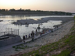
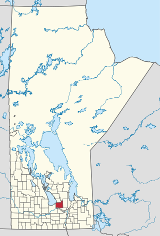
Lockport Provincial Park is a Manitoba provincial park on the east shore of the Red River in the community of Lockport, Manitoba. It is 2.26 ha in size.

Netley Creek Provincial Park is a Manitoba provincial park on the west shore of the Red River north of Selkirk, Manitoba at the mouth of Netley Creek. It provides visitors with access to these waterways and adjacent Netley-Libau Marsh.

Oak Lake is a lake in the southwestern region of the Canadian province of Manitoba.
Sturgeon Bay Provincial Park is a provincial park on the western shore of Lake Winnipeg in Manitoba, Canada. The park is considered to be a Class Ib protected area under the IUCN protected area management categories. It is 144.9 km2 (55.9 sq mi) in size.


