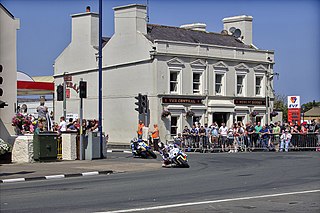
The St. Ninian's Crossroads is a major road junction of the A2 Glencrutchery Road with the A2 Bray Hill, the A22 Ballanard Road and Ballaquayle Road in Douglas. The area is dominated by St. Ninian's Church (dedicated to Ninian of Whithorn) designed by W.D.Caroe and is a major landmark on the skyline of the town of Douglas. The land to build the church in 1913 was bequeathed by Henry Bloom Noble through trustees of his estate.[3] In 1924, the Douglas High School for Boys was constructed on a nearby site by the Isle of Man Education Board and is now the coeducational St Ninian's High School (Schoill Ard Noo Ninian).
The crossroads at St. Ninian's was part of the Highland Course and Four Inch Course used for the Gordon Bennett Trial and Tourist Trophy car races held between 1904 and 1922. The St. Ninian's Crossroads road is part of the Snaefell Mountain Course used since 1911 for the Isle of Man TT races and the Manx Grand Prix since 1923.
During the 1914Junior TT race, Frank Walker's view of the A23 Ballanard Road was obscured by spectators who had encroached onto the road to watch the competitors.[4] Passing the Judges-Box at the finish-line, Walker continued at full racing speed through St. Ninians Crossroads, collided with a wooden barrier in Ballaquayle Road, was thrown from his motorcycle and later died of his injuries at nearby Nobles Hospital.
The St Ninian's Crossroads as Parkfield Corner was part of the Clypse Course used between 1954 and 1959 for the Isle of Man TT and for the Manx Classic Races as part of the Willaston Circuit between 1988 and 2000.
In 1971 the first permanent site of traffic light signals in the Isle of Man were installed at St.Ninian's crossroads.[clarification needed][5] Part of the road junction with Ballaquayle Road and St Ninian's church was widened and re-profiled in 2007 by the Isle of Man Department of Transport.
Sources
↑ Place Names of the Isle of Man by John Kneen MA pp125 (1970) Yn Cheshaght Ghailckagh The Scolar Press
↑ Streets of Douglas: Old and New by Stuart Slack page 141 (1996) (1st Edition) The Manx Experience ISBN978-1873120279
↑ An Illustrated Encyclopedia of the Isle of Man by David T.Webber Revised by Frank Cowin and F.J.Radcliffe pp 24 (1997) The Manx Experience ISBN1-873120-25-7
The Isle of Man TT or Tourist Trophy races are an annual motorcycle racing event run on the Isle of Man in May and June of most years since its inaugural race in 1907. The event begins on the UK Spring Bank Holiday at the end of May and runs for thirteen days. It is often called one of the most dangerous racing events in the world as many competitors have died.
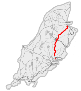
The A18 Snaefell Mountain Road or Mountain Road is a primary main A-road of 13.35 miles (21.48 km) in length which connects the towns of Douglas and Ramsey in the Isle of Man.
The Isle of Man TT Mountain Course or TT Course or Snaefell Mountain Course or Elmo’s Mountain Course is a street and public rural road circuit located in the Isle of Man, used for motorcycle racing. The motorcycle TT Course is used principally for the Isle of Man TT Races and also the separate event of the Isle of Man Festival of Motorcycling for the Manx Grand Prix and Classic TT Races held in September of each year. The start-line for the Isle of Man TT Mountain Course is located on Glencrutchery Road in the City of Douglas, Isle of Man.
Creg-ny-Baa is located between the 3rd Milestone and 4th Milestone of the primary A18 Snaefell Mountain Road and the road junction with the secondary B12 'Creg-ny-Baa Back-Road', in the parish of Kirk Onchan in the Isle of Man.
The TT Grandstand including the startline, pit lane, re-fuellers, merchandising, scoreboard and paddocks for the Isle of Man TT and Manx Grand Prix races is situated on the A2 Glencrutchery Road, in the town of Douglas, Isle of Man.
Bray Hill is a road in the Isle of Man. It was formerly a country lane known as the Great Hill during the time of the ownership of the Duke of Atholl, and was previously known as Siberia, originally a triangle-shaped parcel of land in the Murray Estate.
Highlander is situated between the 5th and 6th Milestone road-side markers on the Snaefell Mountain Course used for the Isle of Man TT races on the primary A1 Douglas to Peel road in the parish of Marown in the Isle of Man.
Governor's Bridge is a hairpin bend adjacent to a road junction on the primary A18 Mountain Road in the parish of Onchan in the Isle of Man, with a sudden drop in elevation leading to Governor's Dip, followed by a left-hand bend and finally a right exiting on to the main Glencrutchery Road.
Parliament Square, Ramsey is situated between the 23rd and 24th Milestone road-side markers on the Snaefell Mountain Course used for the Isle of Man TT Races on the junction of the primary A3 Castletown to Ramsey road, the A9 Ramsey to Andreas road and A2 Douglas to Ramsey road situated in the town of Ramsey in the parish of Lezayre in the Isle of Man.
Ramsey Hairpin is a point on the Snaefell Mountain Course used for the Isle of Man TT races on the Snaefell Mountain Road, designated as A18, in the parish of Maughold in the Isle of Man.
The Four Inch Course was a road-racing circuit first used for the 1908 Tourist Trophy Race for cars, held on public roads closed for racing by an Act of Tynwald. The name of the course derives from the regulations for the 1908 Tourist Trophy adopted by the Royal Automobile Club, which limited the competitors' engines to a cylinder-diameter of four inches. The Four-Inch Course was adopted by the Auto-Cycle Club for the 1911 Isle of Man TT Races. The Four-Inch Course was subsequently known as the Snaefell Mountain Course or Mountain Course when used for motor-cycle racing.
Brandywell, Isle of Man or is an area of Mountain Lands of heath moorland and coniferous woodland plantations situated in the Northern Upland Massif in the parish of Kirk Michael in the Isle of Man. The area was previously used by local shepherds due to a local stream and a nearby former venerated water well which was known for its distinctive quality and "brandy" colour of the water.
The Bungalow, Isle of Man, one of a handful of better-known vantage points spread around the Snaefell Mountain Course, is situated adjacent to the 31st Milestone roadside marker on the road junction of the primary A18 Mountain Road, the A14 Sulby Glen Road and the road-tramway crossing for the Snaefell Mountain Railway in the parish of Lezayre in the Isle of Man.
Cronk-ny-Mona is situated between the 36 and 37 mile markers used for the Snaefell Mountain Course, being on the primary A18 Mountain Road at the road junction with the A21 Johnny Watterson('s) Lane and the tertiary C10 Scholag Road in the Isle of Man parish of Onchan.
Quarterbridge is situated soon after the 1 mile-marker measured from the TT Grandstand, part of the Snaefell Mountain Course used for the Isle of Man TT races, at the junction of the primary A1 Douglas to Peel road, A2 Douglas to Ramsey road and the A5 Douglas to Port Erin road which forms the boundary between the parishes of Braddan and Onchan in the Isle of Man.
Quarterbridge Road is a section of roadway notable for its inclusion in the Isle of Man TT races.
Whitegates, a left-curve, is situated adjacent to the 24th mile road-side marker measured from the start/finish line on the Snaefell Mountain Course used for the Isle of Man TT and Manx Grand Prix motorcycle races. The area also has the historic 15th milestone on the primary A18 Mountain Road, showing the distance from Douglas, Isle of Man to the town of Ramsey.
Douglas Road Corner or Kirk Michael Corner is situated adjacent the 14th Milestone road-side marker on the Snaefell Mountain Course on the primary A3 Castletown to Ramsey Road and the road junction with the A4 Peel to Kirk Michael Coast Road in the parish of Michael in the Isle of Man.
Hailwood's Height, preceded by Hailwood's Rise, is situated between the 31st and 32nd Milestone road-side markers on the Snaefell Mountain Course used for the Isle of Man TT Races on the A18 Snaefell Mountain Road in the parishes of Lezayre and Lonan in the Isle of Man.
The Nook is situated on the primary A18 Mountain Road in the parish of Onchan in the Isle of Man between the 37th Milestone road-side marker on the Snaefell Mountain Course and the TT Grandstand on the primary A2 Glencrutchery Road in the town of Douglas.
This page is based on this Wikipedia article Text is available under the CC BY-SA 4.0 license; additional terms may apply. Images, videos and audio are available under their respective licenses.