This article needs additional citations for verification .(October 2013) |
Starbrick, Pennsylvania | |
---|---|
Country | United States |
State | Pennsylvania |
County | Warren |
Population (2010) | |
• Total | 522 |
Time zone | UTC-5 (Eastern (EST)) |
• Summer (DST) | UTC-4 (EDT) |
ZIP code | 16365 [1] |
Area code | 814 |
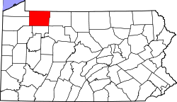
Starbrick is a census-designated place [2] located in Conewango Township, Warren County in the state of Pennsylvania, United States. The community is located along the famous U.S. Route 6, just to the west of the city of Warren. As of the 2010 census [3] the population was 522 residents.
Banks is a town in Pike County, Alabama, United States. As of the 2020 census it had a population of 156, down from 179 in 2010. It incorporated in December 1894.
West Point is a town in White County, Arkansas, United States.
Rome Township is a township in Crawford County, Pennsylvania, United States. The population was 1,993 at the 2020 census, up from 1,840 at the 2010 census.
Sparta Township is a township in Crawford County, Pennsylvania, United States. The population was 1,910 at the 2020 census, up from 1,832 at the 2010 census.
Columbus Township is a township in Warren County, Pennsylvania, United States. The population was 1,604 at the 2020 census, down from 2,034 at the 2010 census.
Conewango Township is a township in Warren County, Pennsylvania, United States. The population was 3,429 at the 2020 census, down from 3,594 at the 2010 census. 3,915 at the 2000 census.
Eldred Township is a township in Warren County, Pennsylvania, United States. The population was 587 at the 2020 census, down from 650 at the 2010 census.
Freehold Township is a township in Warren County, Pennsylvania, United States. The population was 1,214 at the 2020 census, down from 1,510 at the 2010 census.
Sheffield is a census-designated place (CDP) within Sheffield Township in southeastern Warren County, Pennsylvania, United States. It is named after Sheffield, England. The population was 1,123 as of the 2010 census.
Southwest Township is a township in Warren County, Pennsylvania, United States. The population was 426 at the 2020 census, down from 527 at the 2010 census. 561 at the 2000 census.
Sugar Grove is a borough in Warren County, Pennsylvania, United States. The population was 614 at the 2010 census.
Tidioute is a borough in Warren County, Pennsylvania, United States. The population was 688 at the 2010 census.
Warren South is a former census-designated place (CDP) in Warren County, Pennsylvania, United States. The population was 1,651 at the 2000 census.
Youngsville is a borough in Warren County, Pennsylvania, United States. The population was 1,729 at the 2010 census.
Mullins is a city in Marion County, South Carolina, United States. As of the 2010 census, the city population was 4,663.
Michigan's 12th congressional district is a U.S. congressional district in Michigan.
Lanesville Township is located in Sangamon County, Illinois. As of the 2010 census, its population was 208 and it contained 84 housing units. Lanesville Township formed from Illiopolis Township in 1875 under the name of Wheatfield, which was subsequently changed to Lanesville.
Akeley is an unincorporated community in Pine Grove Township, Warren County, Pennsylvania, United States, located at an elevation of 1240 ft (378 m). The community is due north of the similar community of Russell. No population was counted during the 2010 census.
Columbus is a census-designated place located in Columbus Township, Warren County in the state of Pennsylvania, United States. The community is located along the famous U.S. Route 6 in northwestern Warren County. As of the 2010 census, the population was 824 residents. Columbus is within a few miles of the city of Corry, located in Erie County.
North Warren is a census-designated place located along the Conewango Creek in Conewango Township, Warren County in the state of Pennsylvania, United States. The community is located to the north of the city of Warren. As of the 2010 census the population was 1,934 residents.
41°50′25″N79°12′19″W / 41.84028°N 79.20528°W