Related Research Articles
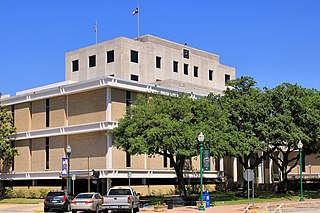
Montgomery County is a county in the U.S. state of Texas. As of the 2020 U.S. census, the county had a population of 620,443. The county seat is Conroe. The county was created by an act of the Congress of the Republic of Texas on December 14, 1837, and is named for the town of Montgomery. Between 2000 and 2010, its population grew by 55%, the 24th-fastest rate of growth of any county in the United States. Between 2010 and 2020, its population grew by 36%. According to the U.S. Census Bureau, the July 1, 2021, estimated population is 648,886.

Atascocita is a census-designated place (CDP) in an unincorporated area within Harris County, Texas, United States within the Houston metropolitan area. As of the 2020 census it had a population of 88,174. It is located north and south of Farm to Market Road 1960 about 6 miles (10 km) east of Humble and 18 miles (29 km) northeast of downtown Houston in northeastern Harris County.

Crosby is a census-designated place in Harris County, Texas, United States. The population was 3,417 at the 2020 census.

Galena Park is a city in Harris County, Texas, United States, within the Houston–Sugar Land–Baytown metropolitan area. The population was 10,740 at the 2020 census.

Hilshire Village is a city in Harris County, Texas, United States. The population was 816 at the 2020 census. The city is the smallest of the Memorial Villages in terms of area.

Humble is a city located in the Houston metropolitan area. Humble became an oil boomtown in the early 20th century when oil was first discovered there in 1904. By 1905, the Humble oilfield was the largest producing oilfield in Texas. Humble was home of The Humble Oil and Refining Company, a predecessor of Exxon.

Jersey Village is a city in west-central Harris County, Texas, United States, located at U.S. Highway 290, Farm to Market Road 529, and the Southern Pacific Railroad. The city is located in the Houston–Sugar Land–Baytown metropolitan area. The population was 7,921 at the 2020 census.

South Houston is a city in the U.S. state of Texas, within Houston–The Woodlands–Sugar Land metropolitan area and Harris County. The population was 16,153 at the 2020 census. It is bordered by the cities of Houston and Pasadena, and geographically located southeast of Houston.
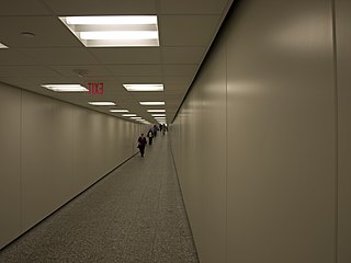
The Houston tunnel system is a network of subterranean, climate-controlled, pedestrian walkways that links 95 full city blocks 20 feet (6 m) below Houston's downtown streets. It is approximately six miles (9.7 km) long. There are similar systems in Chicago, Dallas, Oklahoma City, Montreal, and Toronto. Architectural historian Stephen Fox has stated that the idea for the tunnel system came when the Bank of the Southwest Building was "linked by tunnel to the 1010 Garage and the Mellie Esperson Building" in 1961.
Pecan Park is a neighborhood in Houston, Texas.
Near Northside is a historic neighborhood located in Northside, Houston, Texas. Near Northside is primarily occupied by people of Hispanic descent.
Kohrville, also named Korville and Pilotville, is an unincorporated community in Harris County, Texas.

Bordersville is a predominantly African American community on Farm to Market Road 1960 in northeast Harris County, Texas, United States. The community, located less than one half-mile from George Bush Intercontinental Airport, has about 80% of its territory in the City of Houston and the rest in an unincorporated area.
Fairbanks is a community along U.S. Highway 290 and the Southern Pacific Railroad in Western Houston, Texas, United States. At one point it was a distinct unincorporated area within Harris County.

Almeda is an area located along Texas State Highway 288 and the Missouri Pacific Railroad in Southwest Houston, Texas, United States that used to be a distinct unincorporated community in Harris County. Almeda is 11 miles (18 km) from Downtown Houston.

Denver Harbor is a historic community located in eastern Houston, Texas, United States near the Houston Ship Channel. The community, bounded by Wallisville Road, the Union Pacific Railroad, and the Port Terminal Railroad Association, was first settled in the 1890s and platted in 1911 and 1913. The community includes many historic bungalow and cottage homes.
Barker is an unincorporated community in western Harris County, Texas, United States. It lies along local roads off Interstate 10 and seventeen miles west of downtown Houston. Its elevation is 102 feet (31 m), and it is located at 29°47′4″N95°41′6″W.

Interstate business routes are roads connecting a central or commercial district of a city or town with an Interstate bypass. These roads typically follow along local streets often along a former US route or state highway that had been replaced by an Interstate. Interstate business route reassurance markers are signed as either loops or spurs using a green shield shaped and numbered like the shield of the parent Interstate highway.

Bellaire Boulevard is an arterial road in western Houston, Texas, United States. The street also goes through unincorporated areas in Harris County and the cities of Bellaire, Southside Place, and West University Place.

Westwood is a residential subdivision in Southwest Houston, Texas. The subdivision is bounded by the 610 Loop, the Union Pacific railroad tracks, Stella Link Road, and Willowbend Boulevard. It has about 800 houses.
References
- ↑ City of Houston Planning and Development Department, http://www.houstontx.gov/planning/Annexation/docs_pdfs.pdf
- ↑ Texas Railroad History-Tower 14-Houston, http://www.towers.txrrhistory.com/014/014.htm
- ↑ Historic Houston Streets: The Stories Behind the Name, by Marks Hinton, page 10 "Archived copy" (PDF). Archived from the original (PDF) on 2014-11-14. Retrieved 2013-12-14.
{{cite web}}: CS1 maint: archived copy as title (link) - ↑ Jeannie Kever, http://www.chron.com/neighborhood/katy-news/article/Quirky-street-names-offer-look-into-Houston-s-1784203.php Houston Chronicle . January 25, 2008.

