This article needs additional citations for verification . (August 2017) (Learn how and when to remove this template message) |
![]() | This article may be expanded with text translated from the corresponding article in Swedish. (March 2010)Click [show] for important translation instructions.
|
Native name: Stockholms skärgård | |
---|---|
![]() Map of Stockholm archipelago, covering the area from Arholma in the north to Landsort in the south | |
Geography | |
Location | Baltic Sea |
Coordinates | 59°23′16″N18°44′09″E / 59.38778°N 18.73581°E Coordinates: 59°23′16″N18°44′09″E / 59.38778°N 18.73581°E |
Total islands | ~24,000 |
Major islands | Dalarö, Finnhamn, Nässlingen, Grinda, Husarö, Ingarö, Ljusterö, Möja, Nämdö, Rödlöga, Tynningö, Utö, Svartsö, Värmdö |
Administration | |
County | Stockholm County |
Official name | Svenska Högarna-Nassa |
Designated | 12 June 1989 |
Reference no. | 435 [1] |
The Stockholm archipelago (Swedish : Stockholms skärgård) is the largest archipelago in Sweden, and the second-largest archipelago in the Baltic Sea (the largest being across the Baltic in Finland). Part of the archipelago has been designated as a Ramsar site since 1989. [1]
The water has a pH value of 7.0 (neutral) or slightly lower, to be compared with approximately 8.0 for seawater. Together with humic substances this sometimes causes a bit brownish water colour, especially in the inner parts. The salinity varies between freshwater and brackish water with poor salinity. In the outer parts of the archipelago, the salinity reaches around 0.6–0.7 per cent by weight, to be compared with at least 1.5 for beginning to taste salty and around 3.0 or more for proper oceanic water. Sea ice is regularly formed in the inner parts every winter. [2]
The archipelago extends from Stockholm roughly 60 kilometres (37 miles) to the east. In a north–south direction, it mainly follows the coastline of the Södermanland and Uppland provinces, reaching roughly from Öja island, south of Nynäshamn, to Väddö, north of Norrtälje. It is separated from Åland by a stretch of water named South Kvarken. A separate group of islands lies further north, near the town of Öregrund. Between Arholma and Landsort there are approximately 24,000 islands and islets. [3] Some of the better-known islands are Dalarö, Finnhamn, Nässlingen , Grinda, Husarö, Ingarö, Ljusterö, Möja, Nämdö , Rödlöga, Tynningö, Utö, Svartsö and Värmdö.
The biggest towns of the archipelago, apart from Stockholm, are Nynäshamn, Vaxholm and Norrtälje. The village of Ytterby, famous among chemists for naming no fewer than four chemical elements (erbium, terbium, ytterbium and yttrium), is situated on Resarö in the Stockholm archipelago.
The shipping routes from the Baltic to Stockholm pass through the archipelago. There are three main entrances suitable for deep-draught craft, namely, those near Landsort, Sandhamn, and Söderarm.
The Stockholm archipelago is a joint valley landscape that has been shaped – and is still being shaped – by post-glacial rebound. [4] [5] It was not until the Viking Age that the archipelago began to assume its present-day contours. The islands rise by about three millimeters each year. In 1719 the archipelago had an estimated population of 2,900, consisting mostly of fishermen. Today the archipelago is a popular holiday destination with some 50,000 holiday cottages (owned mainly by Stockholmers). The Stockholm Archipelago Foundation, dedicated to the preservation of the nature and culture of the archipelago, owns some 15% of its total area.
The inhabitants in the archipelago, from around the mid-1400s to the end of the second world war, were combined farmers and fishermen. Spring and autumn fishing was quite intensive in the outer archipelago from 1450 until the mid-1800s, and many fishermen lived for long periods in the outer islands because of the long distances to their permanent houses in the inner archipelago. The combined farming and fishing culture lasted until around 1950–1955 when the younger generation, born during and directly after the war, started to leave the archipelago and look for jobs in the cities on the mainland. Today most of the small farms on the islands are closed and the fishing industry has almost disappeared.
Many poets, authors and artists have been influenced and fascinated by the Stockholm archipelago. Among them are August Strindberg, Ture Nerman, Roland Svensson, Ernst Didring and Aleister Crowley. Björn Ulvaeus and Benny Andersson from the group ABBA wrote most of their songs in a cabin located on the archipelago.
Boating is an extremely popular activity with the sailing race Ornö runt (or Around the island of Ornö) being the largest in the archipelago. This annual race, organised by the Tyresö Boat Club, has taken place every year since 1973. It is open to anyone with a sailing boat but requires registration. There are different entry classes, with the family class being the least competitive.
In the winter skaters make excursions over the ice.
Visiting the larger islands in the archipelago is easy all year round, but during winter period the routes depend on the ice conditions. Several companies have regular routes. The largest ship owner company is Waxholmsbolaget owned by the Stockholm County government. Taxi boats are also available. In summer the archipelago bristles with private boats filled with people who often take advantage of Allemansrätt (or "everyman's right"), a law which gives anyone the right to go ashore or anchor on any ground not in the direct vicinity of buildings.
The Baltic Sea is a mediterranean sea of the Atlantic Ocean, enclosed by Denmark, Estonia, Finland, Latvia, Lithuania, Sweden, northeast Germany, Poland, Russia and the North and Central European Plain.
Nynäshamn Municipality is a municipality in Stockholm County in east central Sweden. Its seat is located in the city of Nynäshamn.
Värmdö Municipality is a municipality in Stockholm County in east central Sweden. Its seat is in the town of Gustavsberg, with a population of 9,682 (2005), on the main island at an elevation of 37 metres (121 ft).
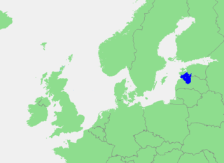
The Gulf of Riga, Bay of Riga, or Gulf of Livonia is a bay of the Baltic Sea between Latvia and Estonia.
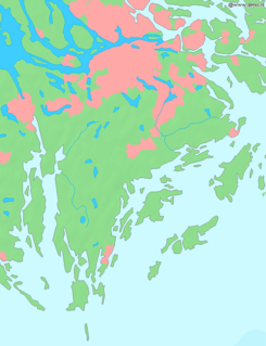
The Archipelago Sea is a part of the Baltic Sea between the Gulf of Bothnia, the Gulf of Finland and the Sea of Åland, within Finnish territorial waters. By some definitions it contains the largest archipelago in the world by the number of islands, although many of the islands are very small and tightly clustered.
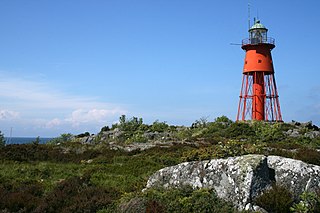
Märket is a small 3.3-hectare (8.2-acre) uninhabited skerry in the Baltic Sea between Sweden and Finland, with a lighthouse as its salient manmade feature. Märket has been divided between the two countries since the Treaty of Fredrikshamn of 1809 defined the border between Sweden and the Russian Empire as going through the middle of the island. The Finnish side of the island is part of the Municipality of Hammarland and is the westernmost land point of Finland. The Swedish part of the island is itself divided by two counties of Sweden: Uppsala County and Stockholm County.
Draget Canal is a Swedish canal in the municipality of Nynäshamn, county of Stockholm and province of Södermanland. Together with other natural channels, it provides a route between the ports of Nynäshamn and Södertälje avoiding the requirement to pass offshore of Landsort, although today it is only used by leisure craft.
Södertörn is a roughly triangular peninsula and artificial island in eastern Södermanland, Sweden, which is bordered by:
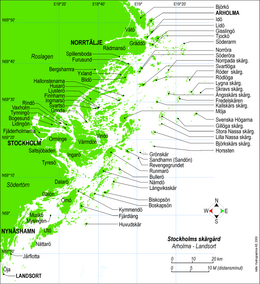
Waxholms Ångfartygs AB, commonly referred to as Waxholmsbolaget, is a shipping company that is owned by Stockholm county council and is responsible for the seaborne public transport in the Stockholm archipelago and Stockholm harbour. The company, which is mostly tax-funded, carried about 4.3 million travellers in 2003, covering a region from Arholma in north of the archipelago to Landsort in the south.
The Bothnian Bay or Bay of Bothnia is the northernmost part of the Gulf of Bothnia, which is in turn the northern part of the Baltic Sea. The land holding the bay is still rising after the weight of ice-age glaciers has been removed, and within 2,000 years the bay will be a large freshwater lake. The bay today is fed by several large rivers, and is relatively unaffected by tides, so has low salinity. It freezes each year for up to six months. Compared to other parts of the Baltic it has little plant or animal life.
Grisslehamn is a locality and port located on the coast of the Sea of Åland in Norrtälje Municipality, Stockholm County, Sweden. The locality had 249 inhabitants in 2010.
Arholma is an island in the northeastern part of the Stockholm archipelago in Norrtälje Municipality. It is 5 kilometres (3.1 mi) long by 2 kilometres (1.2 mi) wide. It is the northernmost island in the archipelago before the Sea of Åland. The island is characterised by a picturesque combination of traditional wooden buildings, farmland, forests and rocky shorelines.
Sandhamn is a small settlement in the central-peripheral part of the Stockholm Archipelago in central-eastern Sweden, approximately 50 km (30 mi) east of Stockholm. Sandhamn is located on the island Sandön, which is, however, colloquially referred to as Sandhamn.
Ornö is the largest island in the southern half of the Stockholm archipelago, situated just north of the island of Utö. It belongs to the municipality of Haninge. The island is approx. 15 km long and 3–4 km wide.
Svenska Högarna is a small group of islands and a lighthouse located east of Möja in the Stockholm archipelago.
Muskö is an island in the southern part of Stockholm archipelago, which forms part of Haninge Municipality, Stockholm County, Sweden. It is best known for the Muskö naval base. There are also two urban areas (tätort) on the island: Muskö and Hoppet.
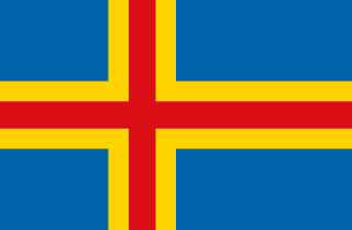
The Åland Islands or Åland is an archipelago province at the entrance to the Gulf of Bothnia in the Baltic Sea belonging to Finland. It is autonomous, demilitarised and is the only monolingually Swedish-speaking region in Finland. It is the smallest region of Finland, constituting 0.51% of its land area and 0.54% of its population.
The Strömma Canal is a short canal located near Strömma, on Värmdö island, Stockholm County, part of Värmdö Municipality in Sweden.
The Luleå archipelago is a group of Swedish islands in the north part of the Bay of Bothnia. They lie offshore from the city of Luleå and the mouth of the Lule River. A few of the islands have small permanent populations, but most are used only for recreation in the summer months. They are icebound during the winter.
Järflotta is an island in Stockholm archipelago, approximately 5 km (3.1 mi) south of Nynäshamn. Once separated from the mainland by a natural sound, this navigable route was rendered unusable in more modern times by post-glacial rebound and has been replaced by the artificial Draget Canal. The island is a nature reserve.
![]() | Wikimedia Commons has media related to Stockholm archipelago . |
![]() | Wikivoyage has a travel guide for Stockholm archipelago . |