
Montgomery County is a county located in the Valley and Ridge area of the U.S. state of Virginia. As population in the area increased, Montgomery County was formed in 1777 from Fincastle County, which in turn had been taken from Botetourt County. As of the 2020 census, the population was 99,721. Its county seat is Christiansburg, and Blacksburg is the largest town. Montgomery County is part of the Blacksburg-Christiansburg metropolitan area. It is dominated economically by the presence of Virginia Tech, Virginia's third largest public university, which is the county's largest employer.

Monongalia County, known locally as Mon County, is located in the U.S. state of West Virginia. As of the 2020 census, the population was 105,822, making it West Virginia's third-most populous county. Its county seat is Morgantown. The county was founded in 1776. Monongalia County is included in the Morgantown, WV Metropolitan Statistical Area, and is the largest county in North-Central West Virginia. It is part of the Pittsburgh media market.

Greenbrier County is a county in the U.S. state of West Virginia. As of the 2020 census, the population was 32,977. Its county seat is Lewisburg. The county was formed in 1778 from Botetourt and Montgomery counties in Virginia.

Bath County is a United States county on the central western border of the Commonwealth of Virginia, on the West Virginia state line. As of the 2020 census, the population was 4,209, the second-least populous county in Virginia. Bath's county seat is Warm Springs.

Arlington County, or simply Arlington, is a county in the U.S. state of Virginia. The county is located in Northern Virginia on the southwestern bank of the Potomac River directly across from Washington, D.C., the national capital.

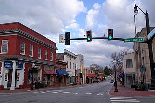
Alleghany County is an American county located on the far western edge of Commonwealth of Virginia. It is bordered by the Allegheny Mountains, from which the county derives its name, and it is the northernmost part of the Roanoke Region. The county seat is Covington. As of the 2020 census, the population was 15,223.

Shepherdsville is a home rule-class city on the Salt River in Bullitt County, Kentucky, in the United States. It is the second largest city and seat of its county, located just south of Louisville. The population was 14,201 during the 2020 U.S. Census.

Tysons, also known as Tysons Corner, is a census-designated place (CDP) in Fairfax County, Virginia, United States, spanning from the corner of SR 123 and SR 7. It is part of the Washington metropolitan area and located in Northern Virginia between McLean and Vienna along the I-495.
Blacksburg is an incorporated town in Montgomery County, Virginia, United States, with a population of 44,826 at the 2020 census. Blacksburg and the surrounding county is dominated economically and demographically by the presence of Virginia Tech.

Glade Spring is a town in Washington County, Virginia, United States. The population was 1,456 at the 2010 census. It is part of the Kingsport–Bristol (TN)–Bristol (VA) Metropolitan Statistical Area, which is a component of the Johnson City–Kingsport–Bristol, TN-VA Combined Statistical Area – commonly known as the "Tri-Cities" region. I-81 runs through Glade Spring. It is located at exit 29.

Martinsburg is a city in and the county seat of Berkeley County, West Virginia, United States. The population was 18,773 at the 2020 census, making Martinsburg the largest city in the Eastern Panhandle of West Virginia and the sixth-largest city in the state. It is a principal city of the Hagerstown–Martinsburg metropolitan area extending into Maryland, which had 293,844 residents in 2020.

Lewisburg is a city in and the county seat of Greenbrier County, West Virginia, United States. The population was 3,930 at the 2020 census.

White Sulphur Springs is a city in Greenbrier County in southeastern West Virginia, United States. The population was 2,231 at the 2020 census. The city emblem consists of five dandelion flowers and the citizens celebrate spring with an annual Dandelion Festival.

Berkeley Springs is a town in, and the county seat of, Morgan County, West Virginia, United States, in the state's Eastern Panhandle. Berkeley Springs is also commonly used to refer to the area in and around the Town of Bath. In 1776, the Virginia Legislature incorporated a town around the springs and named it Bath. Since 1802, it has been referred to by the name of its original post office, Berkeley Springs. The population was 758 at the 2020 census. It is part of the Hagerstown–Martinsburg metropolitan area.

Sterling, Virginia, refers most specifically to a census-designated place (CDP) in Loudoun County, Virginia, United States. The population of the CDP as of the 2020 United States Census was 30,337 The CDP boundaries are confined to a relatively small area between Virginia State Route 28 on the west and Virginia State Route 7 on the northeast, excluding areas near SR 606 and the Dulles Town Center.

South Riding is a census-designated place and planned community in Loudoun County, Virginia, United States. The South Riding homeowner association was founded in January 1995 to provide services to the community. Neighboring U.S. Route 50 and State Route 28 provide access to the Dulles/Reston/Tysons Corner technology corridor and other major employment centers in Northern Virginia and Washington, D.C.

Berkeley Springs State Park is situated in the center of Berkeley Springs, West Virginia, USA. The centerpiece of the Park is its historic mineral spa. These waters were celebrated for their medicinal or restorative powers and were generally taken internally for digestive disorders, or bathed in for stress relief. Native peoples visited these springs as did George Washington. Berkeley Springs is the only state-run spa in the United States and is operated by the West Virginia Division of Natural Resources.
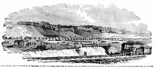
Camp Dennison was a military recruiting, training, and medical post for the United States Army during the American Civil War. It was located near Cincinnati, Ohio, not far from the Ohio River. The camp was named for Cincinnati native William Dennison, Ohio's governor at the start of the war.

The usage and pricing of gasoline results from factors such as crude oil prices, processing and distribution costs, local demand, the strength of local currencies, local taxation, and the availability of local sources of gasoline (supply). Since fuels are traded worldwide, the trade prices are similar. The price paid by consumers largely reflects national pricing policy. Most countries impose taxes on gasoline (petrol), which causes air pollution and climate change; whereas a few, such as Venezuela, subsidize the cost. Some country's taxes do not cover all the negative externalities, that is they do not make the polluter pay the full cost. Western countries have among the highest usage rates per person. The largest consumer is the United States.
Goldfarb v. Virginia State Bar, 421 U.S. 773 (1975), was a U.S. Supreme Court decision. It stated that lawyers engage in "trade or commerce" and hence ended the legal profession's exemption from antitrust laws.


