Summit Chief Mountain

Last updated
Summit Chief Mountain
Summit Chief Mountain, Mt Baker Snoqualmie National Forest.jpg
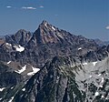
Summit Chief Mountain, north aspect
Highest point
Elevation 7,468 ft (2,276 m)  NAVD 88 [1]
Prominence 1,324 ft (404 m) [1]
Parent peak Chimney Rock (7,727 ft) [2]
Isolation 1.29 mi (2.08 km) [1]
Coordinates 47°31′24″N121°16′06″W / 47.523426°N 121.268252°W / 47.523426; -121.268252  NAVD 88 [3]
Geography
USA Washington relief location map.jpg
Red triangle with thick white border.svg
Summit Chief Mountain
Usa edcp relief location map.png
Red triangle with thick white border.svg
Summit Chief Mountain
Location King County / Kittitas County
Washington, U.S.
Parent range Cascade Range
Topo map USGS Big Snow Mountain
Climbing
First ascent 1925 [4]
Easiest route Scrambling [5] Southeast Face

Summit Chief Mountain is a 7,464-foot (2,275-meter) mountain summit located on the county line separating King County and Kittitas County in Washington state. It is entirely within the Alpine Lakes Wilderness, on land managed by Mount Baker-Snoqualmie National Forest. Summit Chief Mountain is situated on the crest of the Cascade Range, nine miles northeast of Snoqualmie Pass. Precipitation runoff from the west side of the mountain drains into tributaries of the Snoqualmie River, whereas the east side drains into tributaries of the Yakima River. The nearest higher peak is Chimney Rock, 1.29 miles (2.08 km) to the southwest. [1]

Contents

Climate

Summit Chief Mountain is located in the marine west coast climate zone of western North America. [4] Most weather fronts originate in the Pacific Ocean, and travel northeast toward the Cascade Mountains. As fronts approach, they are forced upward by the peaks of the Cascade Range, causing them to drop their moisture in the form of rain or snowfall onto the Cascades (Orographic lift). As a result, the west side of the Cascades experiences high precipitation, especially during the winter months in the form of snowfall. During winter months, weather is usually cloudy, but, due to high pressure systems over the Pacific Ocean that intensify during summer months, there is often little or no cloud cover during the summer. [6] Because of maritime influence, snow tends to be wet and heavy, resulting in avalanche danger. [6]

Geology

The Alpine Lakes Wilderness features some of the most rugged topography in the Cascade Range with craggy peaks and ridges, deep glacial valleys, and granite walls spotted with over 700 mountain lakes. [7] Geological events occurring many years ago created the diverse topography and drastic elevation changes over the Cascade Range leading to the various climate differences. These climate differences lead to vegetation variety defining the ecoregions in this area. The elevation range of this area is between about 1,000 feet (300 m) in the lower elevations to over 9,000 feet (2,700 m) on Mount Stuart.

The history of the formation of the Cascade Mountains dates back millions of years ago to the late Eocene Epoch. [8] With the North American Plate overriding the Pacific Plate, episodes of volcanic igneous activity persisted. [8] In addition, small fragments of the oceanic and continental lithosphere called terranes created the North Cascades about 50 million years ago. [8]

During the Pleistocene period dating back over two million years ago, glaciation advancing and retreating repeatedly scoured the landscape leaving deposits of rock debris. [8] The last glacial retreat in the Alpine Lakes area began about 14,000 years ago and was north of the Canada–US border by 10,000 years ago. [8] The U-shaped cross section of the river valleys is a result of that recent glaciation. Uplift and faulting in combination with glaciation have been the dominant processes which have created the tall peaks and deep valleys of the Alpine Lakes Wilderness area.

See also

Related Research Articles

<span class="mw-page-title-main">Chimney Rock (Washington)</span> Mountain in Washington (state), United States

Chimney Rock is a mountain located in the Alpine Lakes Wilderness of the Central Cascade Range in western Washington, United States. The mountain has two main summits, a northeast spire and a central spire, as well as a minor south peak. Situated 10 miles NNE of Snoqualmie Pass, with its craggy appearance Chimney Rock is the most distinctive peak on the crest dividing the Snoqualmie River and Yakima River drainage areas. Lemah Mountain is to the south on the crest, and Summit Chief Mountain to the northeast. Overcoat Peak is off the main ridge just to the north of Chimney Rock. The mountain has three glaciers: the Overcoat Glacier on the north, the Chimney Glacier on the south and east, and an unnamed glacier on the east side of the North Peak.

<span class="mw-page-title-main">Overcoat Peak</span> Mountain in Washington (state), United States

Overcoat Peak is in Mount Baker-Snoqualmie National Forest in the U.S. state of Washington. Overcoat Peak is less than .40 mi (0.64 km) northwest of Chimney Rock and both are within the Alpine Lakes Wilderness. Overcoat Glacier is on the east slopes of Overcoat Peak.

<span class="mw-page-title-main">Red Mountain (King County, Washington)</span> Mountain in Washington (state), United States

Red Mountain is a 5,890-foot (1,800-metre) mountain summit located in King County of Washington state. It is set within the Alpine Lakes Wilderness which is part of the Cascade Range. Red Mountain is situated three miles north of Snoqualmie Pass on land managed by Mount Baker-Snoqualmie National Forest. The nearest higher neighbor is Lundin Peak, 0.7 mi (1.1 km) to the northwest. Precipitation runoff on the north side of the mountain drains into Middle Fork of the Snoqualmie River, whereas the south side of the mountain drains into the South Fork Snoqualmie River via Commonwealth Creek.

<span class="mw-page-title-main">Kaleetan Peak</span> Mountain in Washington (state), United States

Kaleetan Peak is a prominent 6,259-foot (1,908-metre) mountain summit located in King County of Washington state. It's part of the Cascade Range and is within the Alpine Lakes Wilderness. Kaleetan Peak is situated four miles northwest of Snoqualmie Pass on land managed by Mount Baker-Snoqualmie National Forest. It's immediately west of Melakwa Pass and Chair Peak, and north of Melakwa Lake. Precipitation runoff on the mountain drains into tributaries of the Snoqualmie River. The nearest higher peak is Snoqualmie Mountain, 2.89 miles (4.65 km) to the east. The mountain's name "Kaleetan" derives from Chinook Jargon which means "arrow".

<span class="mw-page-title-main">Garfield Mountain (Washington)</span> Mountain in Washington (state), United States

Garfield Mountain, also known as Mount Garfield, is a multi-peak summit located in King County of Washington state. It's located on the western edge of the Cascade Range and is within the Alpine Lakes Wilderness on land managed by Mount Baker-Snoqualmie National Forest. Mount Garfield is more notable for its large, steep rise above local terrain than for its absolute elevation. Precipitation runoff from the mountain drains into tributaries of the Snoqualmie River. Topographic relief is significant as it rises over 4,400 feet above the river in approximately one mile. The mountain's name honors James A. Garfield, the 20th President of the United States.

<span class="mw-page-title-main">Lundin Peak</span> Mountain in Washington (state), United States

Lundin Peak is a summit located in King County of Washington state. It's part of the Cascade Range and is within the Alpine Lakes Wilderness. Lundin Peak is situated three miles north of Snoqualmie Pass on land managed by Mount Baker-Snoqualmie National Forest. Originally called Snoqualmie Little Sister, the peak's name was changed in 1931 to honor district forest ranger John Lundin. Lundin Peak is a high point on a ridge located midway between Snoqualmie Mountain and Red Mountain. Precipitation runoff from the mountain drains into tributaries of the Snoqualmie River.

<span class="mw-page-title-main">Huckleberry Mountain (Washington)</span> Mountain in Washington (state), United States

Huckleberry Mountain is a 6,320+ ft summit located on the shared border of King County and Kittitas County in Washington state.

<span class="mw-page-title-main">Preacher Mountain</span> Mountain in Washington (state), United States

Preacher Mountain is a broad summit located in King County of Washington state. It's located at the western edge of the Cascade Range and is within the Alpine Lakes Wilderness on land managed by Mount Baker-Snoqualmie National Forest. The nearest higher peak is Kaleetan Peak, 3.11 miles (5.01 km) to the southeast. The Pulpit is situated 2.19 miles to the northwest. Precipitation runoff from the mountain drains into tributaries of the Snoqualmie River.

<span class="mw-page-title-main">Mount Defiance (Washington)</span> Mountain in Washington (state), United States

Mount Defiance is a 5,584-foot (1,702-metre) mountain summit located in King County of Washington state. It's part of the Cascade Range and is within the Alpine Lakes Wilderness. Mount Defiance is situated 6.5 mi (10.5 km) west of Snoqualmie Pass on land managed by Mount Baker-Snoqualmie National Forest. Precipitation runoff on the mountain drains into tributaries of the Snoqualmie River. The nearest higher peak is Granite Mountain, 3.96 mi (6.37 km) to the east-southeast, and Bandera Mountain is 1.85 mi (2.98 km) to the southeast. Mount Defiance can be reached by trail, with access via the Ira Spring, Talapus Lake, or Pratt Lake trailheads.

<span class="mw-page-title-main">Big Snow Mountain</span> Mountain summit of the Cascade Range in King County, Washington State

Big Snow Mountain is a prominent 6,680-foot (2,040-metre) mountain summit located 7 mi (11 km) north of Snoqualmie Pass in the Alpine Lakes Wilderness in eastern King County of Washington state. It is part of the Cascade Range and is situated on land managed by Mount Baker-Snoqualmie National Forest. Precipitation runoff from the mountain drains into tributaries of the Snoqualmie and Skykomish Rivers. The nearest higher peak is Overcoat Peak, 3.75 mi (6.04 km) to the east-southeast.

<span class="mw-page-title-main">Bears Breast Mountain</span> Mountain in Washington (state), United States

Bears Breast Mountain is a 7,197-foot-elevation mountain summit located in Kittitas County of Washington state. It is entirely within the Alpine Lakes Wilderness, on land managed by Wenatchee National Forest. Bears Breast Mountain is situated slightly east of the crest of the Cascade Range, ten miles northeast of Snoqualmie Pass. Not visible from a road, the mountain can be seen from a trail which passes to the southwest of the peak near Dutch Miller Gap. Precipitation runoff from the mountain drains into tributaries of the Waptus River. The nearest higher peak is Little Big Chief Mountain, 1.62 miles (2.61 km) to the southwest.

<span class="mw-page-title-main">Alaska Mountain</span> Mountain in Washington (state), United States

Alaska Mountain is a 5,745-foot (1,751-metre) mountain summit located in the Cascade Range, in Kittitas County of Washington state. It is situated within the Alpine Lakes Wilderness on land managed by Wenatchee National Forest. Alaska Mountain is set between Alaska Lake and Joe Lake, 8 miles (13 km) northeast of Snoqualmie Pass, and 0.81 miles (1.30 km) southeast of Mount Thomson, which is also its nearest higher peak. The Pacific Crest Trail traverses around the south, east and north slopes of Alaska Mountain, and an off-trail hike leads to the summit. Precipitation runoff on the east side of the mountain drains into tributaries of the Yakima River, whereas the west side of the peak drains into tributaries of the Snoqualmie River.

<span class="mw-page-title-main">Mount Roosevelt</span> Mountain in Washington (state), United States

Mount Roosevelt is a 5,835-foot (1,779-metre) mountain summit located 6 mi (10 km) northwest of Snoqualmie Pass, in east King County of Washington state. It's part of the Cascade Range and is situated within the Alpine Lakes Wilderness, on land managed by Mount Baker-Snoqualmie National Forest. Mount Roosevelt is set above the western shore of Snow Lake, and 2 mi (3 km) immediately north of Kaleetan Peak, which is its nearest higher neighbor. Precipitation runoff from the mountain drains into tributaries of the Snoqualmie River. This mountain's name was officially adopted in 1989 by the U.S. Board on Geographic Names.

<span class="mw-page-title-main">Camp Robber Peak</span> Mountain in Washington (state), United States

Camp Robber Peak is a 6,286-foot (1,916-metre) mountain summit located above the western shore of Big Heart Lake, in eastern King County of Washington state. It's part of the Cascade Range, and is situated in the Alpine Lakes Wilderness, on land managed by Mount Baker-Snoqualmie National Forest. Precipitation runoff from the mountain drains into Camp Robber Creek and Foss River, both tributaries of the Skykomish River. This peak's name is derived from Camp Robber Creek and Camp Robber Lake, which lie in Camp Robber Valley to the northwest of the peak. "Camp robber" is the colloquial name for several North American species of birds known for their fearlessness around humans and their proclivity for stealing food from campers. The nearest higher neighbor is Wild Goat Peak, 1.3 mi (2.1 km) to the south.

<span class="mw-page-title-main">Wild Goat Peak</span> Mountain in Washington (state), United States

Wild Goat Peak is a 6,305-foot (1,922-metre) mountain summit located above the eastern shore of Gold Lake, in eastern King County of Washington state. It's part of the Cascade Range, and is situated in the Alpine Lakes Wilderness, on land managed by Mount Baker-Snoqualmie National Forest. Precipitation runoff from the mountain drains into tributaries of the Snoqualmie and Skykomish Rivers. The nearest higher neighbor is Big Snow Mountain, 1.91 mi (3.07 km) to the southwest. This peak was once called "Big Snowy".

<span class="mw-page-title-main">Surprise Mountain</span> Mountain in Washington (state), United States

Surprise Mountain is a 6,330-foot (1,930-metre) mountain summit located above the southern end of Glacier Lake, in eastern King County of Washington state. It's part of the Wenatchee Mountains, which are a subset of the Cascade Range, and is situated in the Alpine Lakes Wilderness, on land managed by Mount Baker-Snoqualmie National Forest. Precipitation runoff from the mountain drains into Surprise Creek and Deception Creek, both tributaries of the Skykomish River. The nearest higher neighbor is Thunder Mountain, 0.88 mi (1.42 km) to the northeast, and Terrace Mountain is set 3 mi (4.8 km) to the southwest. The Pacific Crest Trail skirts this peak as it passes through Surprise Gap.

<span class="mw-page-title-main">Little Big Chief Mountain</span> Mountain in Washington

Little Big Chief Mountain is a 7,225-foot (2,202-metre) mountain summit located immediately southwest of Dutch Miller Gap, on the common border separating King County and Kittitas County in Washington state. It is situated within the Alpine Lakes Wilderness, on land managed by Mount Baker-Snoqualmie National Forest. Little Big Chief Mountain is set ten miles northeast of Snoqualmie Pass on the crest of the Cascade Range. Precipitation runoff from the west side of the mountain drains into tributaries of the Snoqualmie River, whereas the east side drains into tributaries of the Yakima River. The nearest higher peak is Summit Chief Mountain, 0.7 miles (1.1 km) to the southwest, and Chimney Rock is set 2.2 miles (3.5 km) to the southwest. The first ascent of this peak was made in August 1939 by Fred Beckey, Wayne Swift, Joe Barto, and Campbell Brooks. This mountain was named for Lorenz A. Nelson during the 1925 Mountaineers climb of Summit Chief Mountain. Nelson was a pioneering mountaineer who led first ascents of Mount Olympus, Mount Meany, and Chiwawa Mountain.

<span class="mw-page-title-main">Burnt Boot Peak</span> Mountain in Washington (state), United States

Burnt Boot Peak is a 6,520+ ft mountain summit located in the Alpine Lakes Wilderness in eastern King County of Washington state. The peak is part of the Cascade Range and is one mile east of the crest of the range. Burnt Boot Peak is situated 6.5 mi (10.5 km) northeast of Snoqualmie Pass on land managed by Mount Baker-Snoqualmie National Forest. Huckleberry Mountain is set 1.87 mi (3.01 km) to the south, and the nearest higher neighbor is Lemah Mountain, 1.34 mi (2.16 km) to the east. This unofficially-named mountain is located at the head of the officially-named Burnboot Creek, variant spelling Burntboot Creek. Precipitation runoff from the mountain drains south into this creek, or north into Middle Fork Snoqualmie River. The first ascent of this peak was made in August 1963 by Phil Weiser and Clarke Stockwell. The first ascent via the north ridge route was made in June 1971 by Don Williamson, Tom Oas, and Bill Bucher.

<span class="mw-page-title-main">La Bohn Peak</span> Mountain in Washington (state), United States

La Bohn Peak is a 6,585-foot (2,007-metre) mountain summit located two miles north of Dutch Miller Gap, in east King County of Washington state. It is situated at the head of Necklace Valley, in the heart of the Alpine Lakes Wilderness, on land managed by Mount Baker-Snoqualmie National Forest. La Bohn Peak is set west of La Bohn Lakes and La Bohn Gap, and one mile west of the crest of the Cascade Range. Precipitation runoff from the south side of the mountain drains into tributaries of the Snoqualmie River, whereas the north side drains into tributaries of the Foss River. The nearest higher neighbor is Mount Hinman, 1.7 miles (2.7 km) to the east, Little Big Chief Mountain is set 2.3 miles (3.7 km) to the south, and Iron Cap Mountain sits 1.77 miles (2.85 km) to the west.

<span class="mw-page-title-main">Iron Cap Mountain</span> Mountain in Washington (state), United States

Iron Cap Mountain is a 6,347-foot (1,935-metre) mountain summit located two miles west-northwest of Dutch Miller Gap, in east King County of Washington state. It is situated in the heart of the Alpine Lakes Wilderness, on land managed by Mount Baker-Snoqualmie National Forest. Iron Cap Mountain is set two miles west of the crest of the Cascade Range. Precipitation runoff from the south side of the mountain drains into tributaries of the Snoqualmie River, whereas the north side drains into tributaries of the Foss River. Although modest in elevation, relief is significant since Iron Cap rises 2,500 feet above the Middle Fork Snoqalmie River Valley in less than one mile. Its neighbors include La Bohn Peak, 1.77 miles (2.85 km) to the east, and Little Big Chief Mountain, 2.14 miles (3.44 km) to the southeast.

References

  1. 1 2 3 4 "Summit Chief Mountain, Washington". Peakbagger.com.
  2. "Summit Chief Mountain". ListsOfJohn.com. Retrieved 2020-06-21.
  3. "Summit Chief Mountain". Geographic Names Information System . United States Geological Survey, United States Department of the Interior . Retrieved 2021-11-01.
  4. 1 2 Beckey, Fred W. (2008). Cascade Alpine Guide, Climbing and High Routes - Columbia River to Stevens Pass. Vol. 1st. Seattle, WA: Mountaineers Books. ISBN   978-0898861273.
  5. Goldman, Peggy (2014). Washington Scrambles (2nd ed.). Mountaineers Books. ISBN   978-1594858406.
  6. 1 2 Beckey, p. 16
  7. Smoot, Jeff (2004). Backpacking Washington’s Alpine Lakes Wilderness. Helena, Montana: The Globe Pequot Press.
  8. 1 2 3 4 5 Kruckeberg, Arthur (1991). The Natural History of Puget Sound Country. University of Washington Press.