Sunny Side, Georgia

Last updated

Sunny Side, Georgia
city
Spalding County Georgia Incorporated and Unincorporated areas Sunny Side Highlighted.svg
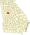
Location in Spalding County and the state of Georgia
USA Georgia location map.svg
Red pog.svg
Sunny Side
Location in Metro Atlanta
Coordinates: 33°20′30″N84°17′25″W / 33.34167°N 84.29028°W / 33.34167; -84.29028
CountryUnited States
State Georgia
Counties Spalding
Area
[1]
  Total0.20 sq mi (0.52 km2)
  Land0.20 sq mi (0.51 km2)
  Water0.00 sq mi (0.01 km2)
Population
 (2020)
  Total203
  Density1,030.46/sq mi (396.98/km2)
FIPS code 13-74572

Sunny Side is a city in Spalding County, Georgia, United States. The population was 142 at the 2000 census.

Contents

History

A post office called Sunny Side was established in 1871. [2] The name "Sunny Side" was commendatorily applied to this place. [3] The Georgia General Assembly incorporated Sunny Side as a town in 1897. [4]

Geography

Sunny Side is located at 33°20′30″N84°17′25″W / 33.34167°N 84.29028°W / 33.34167; -84.29028 (33.341724, -84.290254). [5]

According to the United States Census Bureau, the city has a total area of 0.2 square mile (0.5 km2), all land.

Demographics

Historical population
CensusPop.Note
1880 42
1930 136
1940 123−9.6%
1950 16937.4%
1960 19012.4%
1970 20910.0%
1980 33861.7%
1990 215−36.4%
2000 142−34.0%
2010 134−5.6%
2020 20351.5%
U.S. Decennial Census [6]

As of the census [7] of 2000, there were 142 people, 53 households, and 36 families residing in the city. The population density was 701.3 inhabitants per square mile (270.8/km2). There were 56 housing units at an average density of 276.6 per square mile (106.8/km2). The racial makeup of the city was 97.18% White, and 2.82% from two or more races.

There were 53 households, out of which 30.2% had children under the age of 18 living with them, 52.8% were married couples living together, 11.3% had a female householder with no husband present, and 30.2% were non-families. 24.5% of all households were made up of individuals, and 11.3% had someone living alone who was 65 years of age or older. The average household size was 2.68 and the average family size was 3.14.

In the city, the population was spread out, with 25.4% under the age of 18, 12.0% from 18 to 24, 28.2% from 25 to 44, 21.8% from 45 to 64, and 12.7% who were 65 years of age or older. The median age was 34 years. For every 100 females, there were 121.9 males. For every 100 females age 18 and over, there were 100.0 males.

The median income for a household in the city was $27,083, and the median income for a family was $30,625. Males had a median income of $26,000 versus $17,500 for females. The per capita income for the city was $11,769. There were 14.7% of families and 13.2% of the population living below the poverty line, including 16.1% of under eighteens and 22.2% of those over 64.

Related Research Articles

<span class="mw-page-title-main">Spalding County, Georgia</span> County in Georgia, United States

Spalding County is a county located in the west central portion of the U.S. state of Georgia. As of the 2020 census, the population was 67,306. The county seat is Griffin. The county was created December 20, 1851 and named for former United States representative and senator Thomas Spalding.

<span class="mw-page-title-main">Pike County, Georgia</span> County in Georgia, United States

Pike County is a county located in the west central portion of the U.S. state of Georgia. As of the 2020 census, the population was 18,889. The county seat is Zebulon.

<span class="mw-page-title-main">Meriwether County, Georgia</span> County in Georgia, United States

Meriwether County is a county located in the west central portion of the U.S. state of Georgia. As of the 2020 census, the population was 20,613. The county seat is Greenville, home of the Meriwether County Courthouse. The county was formed on December 14, 1827, as the 73rd county in Georgia. It was named for David Meriwether, a general in the American Revolutionary War and member of Congress from Georgia.

<span class="mw-page-title-main">Lamar County, Georgia</span> County in Georgia, United States

Lamar County is a county located in the west central portion of the U.S. state of Georgia. As of the 2020 census, the population was 18,500. The county seat is Barnesville.

<span class="mw-page-title-main">Lake City, Georgia</span> City in Georgia, United States

Lake City is a city in Clayton County, Georgia, United States. The population was 2,612 at the 2010 census.

<span class="mw-page-title-main">Morrow, Georgia</span> City in Georgia, United States

Morrow is a city in Clayton County, Georgia, United States. It is part of the Atlanta metropolitan area. Its population was 6,445 at the 2010 census, up from 4,882 in 2000. It is the home of Clayton State University and the Georgia Archives.

<span class="mw-page-title-main">Grantville, Georgia</span> City in Georgia, United States

Grantville is a city in Coweta County, Georgia, United States. The 2010 census shows a population of 3,041.

<span class="mw-page-title-main">Haralson, Georgia</span> Town in Georgia, United States

Haralson is a town in Coweta and Meriwether counties in the U.S. state of Georgia. The population was 172 at the 2020 census. It is noted for being one of the filming locations for both The Walking Dead and Lawless.

<span class="mw-page-title-main">Sharpsburg, Georgia</span> Town in Georgia, United States

Sharpsburg (ˈʃɑrpsbɝg) is a town in Coweta County, Georgia, United States. It is part of the Atlanta metropolitan area. Its population was 327 at the 2020 census.

<span class="mw-page-title-main">Morganton, Georgia</span> City in Georgia, United States

Morganton is a city in Fannin County, Georgia, United States. The population was 285 at the 2020 census.

<span class="mw-page-title-main">Tyrone, Georgia</span> Town in Georgia, United States

Tyrone is a town in Fayette County, Georgia, United States. The population was 6,879 at the 2010 census, up from 3,916 in 2000. The estimated population in 2018 was 7,388. It is a part of the Atlanta metropolitan area.

<span class="mw-page-title-main">Hampton, Georgia</span> City in Georgia, United States

Hampton is a city in southwestern Henry County, Georgia, United States. The 2020 census was 8368. As of the 2010 census, the city had a population of 6,987, up from 3,857 at the 2000 census. By 2018 the estimated population was 7,922. "Hampton" mailing addresses outside the city limits reach into rural parts of eastern Clayton County and northern Spalding County. It is a southeastern suburb in the Atlanta metropolitan area.

<span class="mw-page-title-main">Aldora, Georgia</span> Town in Georgia, United States

Aldora is a town in Lamar County, Georgia, United States. As of the 2020 census, the city had a recorded population of 0, due to a "0 percent self-response rate" to the 2020 census. The actual population was estimated at 103.

<span class="mw-page-title-main">Milner, Georgia</span> City in Georgia, United States

Milner is a city in Lamar County, Georgia, United States. The population was 610 at the 2010 census, up from 522 at the 2000 census.

<span class="mw-page-title-main">Luthersville, Georgia</span> City in Georgia, United States

Luthersville is a city in Meriwether County, Georgia, United States. The population was 776 at the 2020 census, down from 874 in 2010.

<span class="mw-page-title-main">Woodbury, Georgia</span> City in Georgia, United States

Woodbury is a city in Meriwether County, Georgia, United States. The population was 908 at the 2020 census.

<span class="mw-page-title-main">Molena, Georgia</span> City in Georgia, United States

Molena is a city in Pike County, Georgia, United States. The population was 475 at the 2000 census.

<span class="mw-page-title-main">Zebulon, Georgia</span> City in Georgia, United States

Zebulon is a city in Pike County, Georgia, United States. The population was 1,174 at the 2010 census. The city is the county seat of Pike County. The city and county were named after explorer Zebulon Pike.

<span class="mw-page-title-main">Green Valley, Maryland</span> Census-designated place in Frederick County, Maryland, United States

Green Valley is an unincorporated area and census-designated place (CDP) in southern Frederick County, Maryland, United States. The population was 12,643 at the 2020 census. The area was listed as a census-designated place in 2000 but not listed as part of any CDP at the 2010 census. It was re-designated a census-designated place for the 2020 census.

<span class="mw-page-title-main">Rome, Pennsylvania</span> Borough in Pennsylvania, United States

Rome is a borough in Bradford County, Pennsylvania, United States. It is part of Northeastern Pennsylvania. The population was 385 at the 2020 census.

References

  1. "2020 U.S. Gazetteer Files". United States Census Bureau. Retrieved December 18, 2021.
  2. "Post Offices". Jim Forte Postal History. Retrieved June 20, 2019.
  3. Krakow, Kenneth K. (1975). Georgia Place-Names: Their History and Origins (PDF). Macon, GA: Winship Press. p. 216. ISBN   0-915430-00-2.
  4. Acts of the General Assembly of the State of Georgia. Clark & Hines, State Printers. 1898. p. 313.
  5. "US Gazetteer files: 2010, 2000, and 1990". United States Census Bureau. February 12, 2011. Retrieved April 23, 2011.
  6. "Census of Population and Housing". Census.gov. Retrieved June 4, 2015.
  7. "U.S. Census website". United States Census Bureau . Retrieved January 31, 2008.