Susunia, Purulia

Last updated

Susunia
Village
West Bengal location map.svg
Red pog.svg
Susunia
Location in West Bengal, India
India location map.svg
Red pog.svg
Susunia
Susunia (India)
Coordinates: 22°57′22″N86°36′21″E / 22.9562°N 86.6058°E / 22.9562; 86.6058
CountryFlag of India.svg  India
State West Bengal
District Purulia
Population
 (2011)
  Total650
Languages
  Official Bengali, English
Time zone UTC+5:30 (IST)
PIN
723131
Telephone/STD code03253
Lok Sabha constituency Jhargram
Vidhan Sabha constituency Bandwan
Website purulia.gov.in

Susunia (also called Sushina) is a village in the Manbazar II CD block in the Manbazar subdivision of the Purulia district in the state of West Bengal, India.

Contents

Geography

Susunia, Purulia
Places in Manbazar subdivision in Purulia district
CT: census town, R: rural/ urban centre, H: historical/ religious centre
Owing to space constraints in the small map, the actual locations in a larger map may vary slightly

Location

Susunia is located at 22°57′22″N86°36′21″E / 22.9562°N 86.6058°E / 22.9562; 86.6058 .

Area overview

Purulia district forms the lowest step of the Chota Nagpur Plateau. The general scenario is undulating land with scattered hills. Manbazar subdivision, shown in the map alongside, is located in the eastern part of the district. It is an overwhelmingly rural subdivision with 96.32% of the population living in the rural areas and 3.68% living in the urban areas. There are 3 census towns in the subdivision. The map shows the Kangsabati Project Reservoir. The Mukutmanipur Dam is in Bankura district but the upper portion of the reservoir is in Manbazar subdivision. The remnants of old temples and deities are found in the subdivision also, as in other parts of the district. The subdivision has a very high proportion of Scheduled Castes and Scheduled Tribes. Bandwan CD block has 51.86% ST population, Manbazar II CD block has 48.97% ST population. Manbazar I CD block has 22.03% ST and 22.44% SC. Puncha CD block has 24.74% ST and 14.54 SC. [1] [2] [3] [4] Writing in 1911, H. Coupland, ICS, speaks of the aboriginal races largely predominating in the old Manbhum district. He particularly mentions the Kurmis, Santhals, Bhumij and Bauri. [5]

Note: The map alongside presents some of the notable locations in the subdivision. All places marked in the map are linked in the larger full screen map.

Demographics

According to the 2011 Census of India, Sushina had a total population of 650, of which 336 (52%) were males and 314 (48%) were females. There were 75 persons in the age range of 0–6 years. The total number of literate persons in Sushina was 303 (52.70% of the population over 6 years). [6]

Education

Government General Degree College, Manbazar II at Susunia was established in 2015. Affiliated with the Sidho Kanho Birsha University, it offers honours courses in Bengali, Santali, English, philosophy, political science, sociology, mathematics, geology, and general courses in arts and science. [7]

Eklavya Model Residential School, at Susunia, has intake capacity of 420 students. It is a residential school for Indian tribals providing free education, food, lodging etc. set up by the Government of India. [8]

Transport

Susunia is on the State Highway 5. [9]

Related Research Articles

Barabazar is a census town in the Barabazar CD block in the Manbazar subdivision of the Purulia district in the state of West Bengal, India. Before Indian independence in 1947, it was the capital of an expensive zamindari of Barabhum in British India.

<span class="mw-page-title-main">Manbazar I</span> Community development block in West Bengal, India

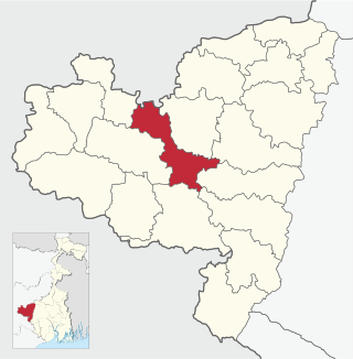
Manbazar I is a community development block that forms an administrative division in the Manbazar subdivision of the Purulia district in the Indian state of West Bengal.

<span class="mw-page-title-main">Puncha (community development block)</span> Community development block in West Bengal, India

Puncha is a community development block that forms an administrative division in the Manbazar subdivision of the Purulia district in the Indian state of West Bengal.

Bandwan is a census town in the Bandwan CD block in the Manbazar subdivision of the Purulia district in the state of West Bengal, India.

Manbazar is a census town in Manbazar I CD block in Manbazar subdivision of Purulia district in the state of West Bengal, India. The headquarters of Manbazar subdivision are located in Manbazar.

<span class="mw-page-title-main">Manbazar II</span> Community development block in West Bengal, India

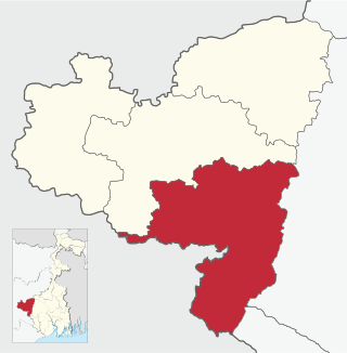
Manbazar II is a community development block that forms an administrative division in the Manbazar subdivision of the Purulia district in the Indian state of West Bengal.

<span class="mw-page-title-main">Purulia I</span> Community development block in West Bengal, India

Purulia I is a community development block that forms an administrative division in the Purulia Sadar subdivision of the Purulia district in the Indian state of West Bengal.

<span class="mw-page-title-main">Barabazar (community development block)</span> Community development block in West Bengal, India

Barabazar is a community development block that forms an administrative division in the Manbazar subdivision of the Purulia district in the Indian state of West Bengal.

<span class="mw-page-title-main">Raghunathpur II</span> Community development block in West Bengal, India

Raghunathpur II is a community development block that forms an administrative division in the Raghunathpur subdivision of the Purulia district in the Indian state of West Bengal.

<span class="mw-page-title-main">Santuri (community development block)</span> Community development block in West Bengal, India

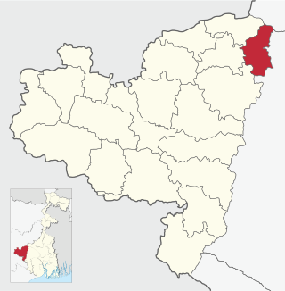
Santuri is a community development block that forms an administrative division in the Raghunathpur subdivision of the Purulia district in the Indian state of West Bengal.

Kenda is a village, with a police station, in the Manbazar I CD block in the Manbazar subdivision of the Purulia district in the state of West Bengal, India.

Boro is a village, with a police station, in the Manbazar II CD block in the Manbazar subdivision of Purulia district in the state of West Bengal, India.

Puncha is a village, with a police station, and a gram panchayat in the Puncha CD block in the Manbazar subdivision of the Purulia district in the state of West Bengal, India.

Bargoria is a village in the Manbazar II CD block in the Manbazar subdivision of the Purulia district in the state of West Bengal, India.

<span class="mw-page-title-main">Manbazar subdivision</span> Subdivision in West Bengal, India

Manbazar subdivision is a subdivision of the Purulia district in the state of West Bengal, India.

Laulara is a village in the Puncha CD block in the Manbazar subdivision of the Purulia district in the state of West Bengal, India.

Kuruktopa is a village in the Puncha CD block in the Manbazar subdivision of the Purulia district in the state of West Bengal, India.

Pakbirra is a village in the Puncha CD block in the Manbazar subdivision of the Purulia district in the state of West Bengal, India.

Chharra is a village in the Purulia II CD block in the Purulia Sadar subdivision of the Purulia district in the state of West Bengal, India.

Budhpur is a village in the Manbazar I CD block in the Manbazar subdivision of the Purulia district in the state of West Bengal, India.

References

  1. Houlton, Sir John, Bihar, the Heart of India, 1949, p. 170, Orient Longmans Ltd.
  2. "District Statistical Handbook 2014 Purulia". Tables 2.1, 2.2. Department of Planning and Statistics, Government of West Bengal. Retrieved 12 January 2020.
  3. "CD block Wise Primary Census Abstract Data(PCA)". 2011 census: West Bengal – District-wise CD blocks. Registrar General and Census Commissioner, India. Retrieved 16 January 2020.
  4. "Travel and Tourism : Purulia". The Official Website of Purulia District.
  5. "Bengal District Gazetteers – Manbhum by H. Coupland". Page 76: Manbhum, Castes and Tribes. University of California, San Diego. Retrieved 10 February 2020.
  6. "C.D. Block Wise Primary Census Abstract Data(PCA)". West Bengal – District-wise CD Blocks. Registrar General and Census Commissioner, India. Retrieved 19 January 2020.
  7. "Government General Degree College, Manbazar - II". GGDC. Retrieved 19 January 2020.
  8. "Eklavya Model Residential School" . Retrieved 19 January 2020.
  9. Google maps