
New Zealand is an island country located in the south-western Pacific Ocean, near the centre of the water hemisphere. It consists of a large number of islands, estimated around 600, mainly remnants of a larger land mass now beneath the sea. The two main islands by size are the North Island and the South Island, separated by the Cook Strait. The third-largest is Stewart Island, located 30 kilometres off the tip of the South Island across Foveaux Strait. Other islands are significantly smaller in area. The three largest islands stretch 1,500 kilometres across latitudes 34° to 47° south. New Zealand is the sixth-largest island country in the world, with a land size of 267,710 km2 (103,360 sq mi).

Moa were nine species of now-extinct flightless birds endemic to New Zealand. The two largest species, Dinornis robustus and Dinornis novaezelandiae, reached about 3.6 m (12 ft) in height with neck outstretched, and weighed about 230 kg (510 lb). Estimates of the Moa population when Polynesians settled New Zealand circa 1280, vary between 58,000 to c. 2.5 million.

Tasman District is a local government district in the north of the South Island of New Zealand. It borders the Canterbury Region, West Coast Region, Marlborough Region and Nelson City. It is administered by the Tasman District Council, a unitary authority, which sits at Richmond, with community boards serving outlying communities in Motueka and Golden Bay / Mohua. The city of Nelson has its own unitary authority separate from Tasman District, and together they comprise a single region in some contexts, but not for local government functions or resource management (planning) functions.
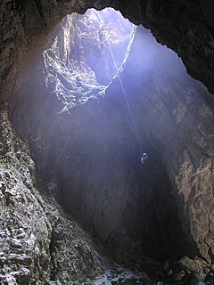
Harwoods Hole is a cave system located in the northwest of the South Island of New Zealand. At 183 metres (600 ft), it is New Zealand's deepest vertical shaft. It was first explored in 1958, long after it was discovered.

Mount Owen is in the Tasman district of the South Island of New Zealand. It stands at 1875 metres (6150 feet) above sea level and is part of the Marino Mountains.

Takaka is a small town situated at the southeastern end of Golden Bay, at the northern end of New Zealand's South Island, located on the lower reaches of the Takaka River. It lies at the start of the winding road which follows the river valley before climbing over Takaka Hill, linking Golden Bay with the more populated coast of Tasman Bay to the southeast. The town is served by Takaka Aerodrome.
The Riuwaka River, formerly known as the Riwaka River, is located in the Nelson region in the northwest of New Zealand's South Island. It flows for 20 kilometres, entering Tasman Bay close to the town of Riwaka, 10 kilometres north of Motueka.

Bulmer Cavern is New Zealand's longest cave system, running for 66 km through Mount Owen in the Tasman region of the northwest South Island. John Patterson discovered the cave on New Year's Day 1984, by dropping a rock down and counting the seconds until it reached the bottom.
Caving in New Zealand is an established hobby as well as being a part of commercial tourism.

The Tasman Region, and the small adjoining Nelson Region, form one of the more geologically interesting regions of New Zealand. It contains the oldest rocks of anywhere on New Zealand's main islands. It contains all the main terranes that make up New Zealand's basement. These basement rocks include Ultramafic rocks, such as Serpentine and Dunite, and valuable minerals, such as Gold. The Nelson Region is bordered to the south by the Alpine Fault, the main fault forming the boundary between the Pacific Plate and the Indo-Australian Plate, that generated the Southern Alps.
Takaka County was one of the counties of New Zealand in the South Island.
Ann Lovell, her husband James and their children were the first European settlers in Golden Bay at Motupipi, east of Takaka, New Zealand. Lovell was described in her biography as a homemaker, gold courier and shopkeeper. She was born about 1803/4.
The Oparara Basin is a basin drained by the Oparara River at 20 kilometres (12 mi) north of Karamea, at the West Coast Region of the South Island of New Zealand. With its large natural rock arches, a network of caves rich in fossils, and a beautiful, unspoiled natural environment typical of temperate rainforests, it is one of the most striking places of the Kahurangi National Park.

Obrh Creek is a losing stream that originates and terminates in the Lož Karst Field in the Municipality of Loška Dolina. It is a watercourse in the Ljubljanica watershed. It is created by the confluence of Little Obrh Creek and Big Obrh Creek ; the latter is fed by two tributaries: Brežiček Creek and Viševek Brežiček Creek. The confluence, at which point it is simply named Obrh, lies west of the village of Pudob. In the northwest, limestone part of the karst field, Obrh Creek starts to drain into many sinkholes, and higher water flows into 850-meter (2,790 ft) Golobina Cave. The stream re-emerges at the spring of the Stržen River 2 kilometers (1.2 mi) to the northwest on the southeast edge of the Cerknica Karst Field.

The Ngārua Caves are a series of limestone caves in the Takaka Hill range south of Abel Tasman National Park.

Rawhiti Cave, also known as Manson Cave, is a single large limestone cave in the hillside of the Dry Creek Valley 7 kilometres (4.3 mi) southeast of Takaka on the South Island of New Zealand. It is referred to as Manson Cave in the NZ Topo Map, after owners in the early 20th century, however the cave is known as Rawhiti Cave locally, and on DoC information panels and in brochures.

The Takaka Terrane is a Paleozoic terrane that outcrops in the South Island of New Zealand. It is most extensively exposed within the Kahurangi National Park in the Tasman District. The terrane is mostly made up of marble and volcanic rocks but is highly variable in composition. It ranges in age from mid-Cambrian to Devonian time, including New Zealand's oldest rocks, which are found in the Cobb Valley in north-west Nelson. The Cobb Valley is also the location of "Trilobite Rock" a glacial dropstone made from the moulted exoskeletons of trilobites. Asbestos was mined in the Cobb Valley from the Takaka Terrene between the late 1880s and 1917. The Takaka Terrane is highly deformed and has been intruded by many batholiths.
