Reims – Champagne Air Base is a former Front-line French Air and Space Force air base. The base is located approximately 4 miles (6.4 km) north of Reims; about 81 miles (130 km) northeast of Paris.

Le Luc-Le Cannet Airport is an airport located at Le Cannet-des-Maures, 6 km (4 mi) east of Le Luc, in the Var department of the Provence-Alpes-Côte d'Azur region in southern France. The airport is open to public air traffic, but has no commercial airline service. It also has military use as part of Base école Général Lejay, a French Army training facility for combat helicopters and various ground equipment.
Lunéville-Croismare Airport is an airport in France, located approximately 3 km east-southeast of Lunéville in the Meurthe-et-Moselle department. The airport is used for general aviation, with no commercial airline service.
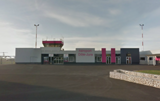
Dole–Jura Airport, also known as Dole–Besançon–Dijon Airport, is an airport serving Dole, a commune in the Jura department in the Bourgogne-Franche-Comté region in eastern France. The airport is located 7 km (4 NM) southwest of Dole, and southeast of Tavaux. It was formerly known as Dole–Tavaux Airport. The airport is used for general aviation, and for a few commercial airline services.
La Vallon Airfield is an abandoned World War II military airfield in France. It is located 13 km north of Istres in Bouches-du-Rhône.
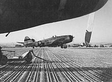
Loyettes Airfield is an abandoned World War II United States Army Air Forces military airfield in France, which was located approximately 1 km north of Loyettes, 28 km east of Lyon. It was located at a prewar grass airdrome, which was improved by the XII Engineer Command for military aircraft use. It was known as Advanced Landing Ground Y-25.
Meautis Airfield is an abandoned World War II military airfield, which is located near the commune of Méautis in the Normandy region of northern France.

Brucheville Airfield is an abandoned World War II military airfield, which is located near the commune of Brucheville in the Normandy region of northern France.
Cretteville Airfield is an abandoned World War II military airfield, which is located near the commune of Cretteville in the Normandy region of northern France.

Tour-en-Bessin Airfield is a now-abandoned World War II military airfield near the commune of Tour-en-Bessin in the Normandy region of northern France.
Pontorson Airfield is an abandoned World War II military airfield, which is located near the commune of Pontorson in the Normandy region of northern France.
Saint James Airfield is an abandoned World War II military airfield, which is located near the commune of Saint-James in the Normandy region of northern France.
Vannes Airport is a regional airport in France. It supports general aviation.
Perthes Airfield is an abandoned World War II military airfield, which is located near the commune of Perthes in the Champagne-Ardenne department of northern France.
Mourmelon-le-Grand Airfield is an abandoned World War II military airfield in France. It lies approximately 1 mile (2 km) east-southeast of Mourmelon-le-Grand and 93 miles (150 km) northeast of Paris.
Zutendaal Air Base is a reserve Belgian Air Component base, located 4 mi (6.4 km) east-southeast of Genk (Limburg), approximately 50 mi (80 km) east-northeast of Brussels.
Ophoven Airfield is an abandoned World War II military airfield which is located west of Opglabbeek (Limburg); approximately 54 miles (87 km) northeast of Brussels.
Strassfeld Airfield is an abandoned World War II military airfield located in Germany, about 5 miles east-northeast of Euskirchen in Nordrhein-Westfalen; approximately 310 miles southwest of Berlin.
Mendig Air Base is a former military air base located southeast of the city of Mendig, Rhineland-Palatinate, Germany.
Saint-Léonard Airfield is a former World War II airfield, located 1.8 km east of Louplande in the Pays de la Loire region, France.