Techo (wetland)

Last updated
Techo Wetland
Humedal del Techo
Colombia Bogota location map.png
Green pog.svg
Location in Bogotá
Location Techo, Kennedy, Bogotá
Flag of Colombia.svg  Colombia
Coordinates 4°38′53.0″N74°08′35.0″W / 4.648056°N 74.143056°W / 4.648056; -74.143056 Coordinates: 4°38′53.0″N74°08′35.0″W / 4.648056°N 74.143056°W / 4.648056; -74.143056
Area 11.67 ha (28.8 acres)
Elevation 2,544.8 m (8,349 ft)
Designated September 2003
Named for Muysccubun: cacique Techovita
Administrator EAAB - ESP
Website Humedal del Techo

Techo (Spanish : Humedal del Techo) is a wetland, part of the Wetlands of Bogotá, located in the neighbourhood Techo in the locality Kennedy, Bogotá, Colombia. The wetland on the Bogotá savanna covers an area of about 11.6 hectares (29 acres). [1] Techo is located in the basins of the Bogotá River and its main tributaries Fucha and Tunjuelo. [2]

Spanish language Romance language

Spanish or Castilian, is a Western Romance language that originated in the Castile region of Spain and today has hundreds of millions of native speakers in the Americas and Spain. It is a global language and the world's second-most spoken native language, after Mandarin Chinese.

Wetland A land area that is permanently or seasonally saturated with water

A wetland is a distinct ecosystem that is inundated by water, either permanently or seasonally, where oxygen-free processes prevail. The primary factor that distinguishes wetlands from other land forms or water bodies is the characteristic vegetation of aquatic plants, adapted to the unique hydric soil. Wetlands play a number of functions, including water purification, water storage, processing of carbon and other nutrients, stabilization of shorelines, and support of plants and animals. Wetlands are also considered the most biologically diverse of all ecosystems, serving as home to a wide range of plant and animal life. Whether any individual wetland performs these functions, and the degree to which it performs them, depends on characteristics of that wetland and the lands and waters near it. Methods for rapidly assessing these functions, wetland ecological health, and general wetland condition have been developed in many regions and have contributed to wetland conservation partly by raising public awareness of the functions and the ecosystem services some wetlands provide.

Wetlands of Bogotá

Wetlands of Bogotá, Colombia are important areas of the capital city, and their development has become increasingly important for the area north of the Andes. A reserve for fauna and flora, the wetlands provide for the preservation and reproduction of a wide variety of mammals, reptiles and birds. These include more than 70 species of migratory birds, as well as many endemic plant species. The wetlands are part of the Bogotá River basin.

Contents

Etymology

The name Techo is taken from Techovita, the name of a cacique in the Muisca Confederation, the former country on the Altiplano Cundiboyacense before the Spanish conquest. [3]

A cacique is a leader of an indigenous group, derived from the Taíno word kasikɛ for the pre-Columbian tribal chiefs in the Bahamas, the Greater Antilles, and the northern Lesser Antilles. In the colonial era, Spaniards extended the word as a title for the leaders of practically all indigenous groups that they encountered in the Western Hemisphere. In Spanish America, Brazil, Spain, and Portugal, the term also has come to mean a political boss or leader who exercises significant power in the political system known as caciquismo.

Muisca Confederation loose confederation of different Muisca rulers (zaques, zipas, iraca and tundama) in the central Andean highlands of present-day Colombia before the Spanish conquest of northern South America

The Muisca Confederation was a loose confederation of different Muisca rulers in the central Andean highlands of present-day Colombia before the Spanish conquest of northern South America. The area, presently called Altiplano Cundiboyacense, comprised the current departments of Boyacá, Cundinamarca and minor parts of Santander with a total surface area of approximately 25,000 square kilometres (9,700 sq mi).

Altiplano Cundiboyacense

The Altiplano Cundiboyacense[altiˈplano kundiβoʝaˈsense] is a high plateau located in the Eastern Cordillera of the Colombian Andes covering parts of the departments of Cundinamarca and Boyacá. The altiplano corresponds to the ancient territory of the Muisca. The Altiplano Cundiboyacense comprises three distinctive flat regions; the Bogotá savanna, the valleys of Ubaté and Chiquinquirá, and the valleys of Duitama and Sogamoso. The average altitude of the altiplano is about 2,600 metres (8,500 ft) above sea level but ranges from roughly 2,500 metres (8,200 ft) to 4,000 metres (13,000 ft).

Flora and fauna

The common nighthawk is in the wetlands of Bogota uniquely registered in Techo Common Nighthawk (14427569838).jpg
The common nighthawk is in the wetlands of Bogotá uniquely registered in Techo

Flora

Flora registered in Techo are among others Hydrocotyle ranunculoides , Lemna minor , Typha latifolia and Juncus bogotensis . [4]

<i>Hydrocotyle ranunculoides</i> species of plant

Hydrocotyle ranunculoides, known commonly as floating pennywort, or floating marshpennywort, is an aquatic plant in the family Araliaceae. It is native to North and South America and parts of Africa.

<i>Lemna minor</i> species of plant

Lemna minor, the common duckweed or lesser duckweed, is an aquatic freshwater plant of the genus Lemna. They belong to the family of Lemnaceae, which are monophyletic to the Araceae family. L. minor is used as animal fodder, bioremediator, for wastewater nutrient recovery, and other applications.

<i>Typha latifolia</i> species of plant

Typha latifolia is a perennial herbaceous plant in the genus Typha. It is found as a native plant species in North and South America, Europe, Eurasia, and Africa. In Canada, broadleaf cattail occurs in all provinces and also in the Yukon and Northwest Territories, and in the United States, it is native to all states except Hawaii. It is an introduced and invasive species, and is considered a noxious weed, in Australia and Hawaii. It has been reported in Indonesia, Malaysia, New Zealand, Papua New Guinea, and the Philippines.

Birds

In Techo, 53 bird species have been registered, of which one endemic, uniquely to this wetland, the common nighthawk (Chordeiles minor. [5] [6]

Endemism ecological state of being unique to a defined geographic location or habitat

Endemism is the ecological state of a species being unique to a defined geographic location, such as an island, nation, country or other defined zone, or habitat type; organisms that are indigenous to a place are not endemic to it if they are also found elsewhere. The extreme opposite of endemism is cosmopolitan distribution. An alternative term for a species that is endemic is precinctive, which applies to species that are restricted to a defined geographical area.

Common nighthawk species of bird

The common nighthawk is a medium-sized crepuscular or nocturnal bird within the nightjar family, whose presence and identity are best revealed by its vocalization. Typically dark, displaying cryptic colouration and intricate patterns, this bird is difficult to spot with the naked eye during the day. Once aerial, with its buoyant but erratic flight, this bird is most conspicuous. The most remarkable feature of this aerial insectivore is its small beak that belies the massiveness of its mouth. Some claim appearance similarities to owls. With its horizontal stance and short legs, the common nighthawk does not travel frequently on the ground, instead preferring to perch horizontally, parallel to branches, on posts, on the ground or on a roof. The males of this species may roost together but the bird is primarily solitary. The common nighthawk shows variability in territory size.

Other bird species as the yellow-hooded blackbird (Chrysomus icterocephalus bogotensis), great crested flycatcher (Myiarchus crinitus) and black flowerpiercer (Diglossa humeralis) have been spotted in Techo. [1]

Yellow-hooded blackbird species of bird

The yellow-hooded blackbird is a species of bird in the family Icteridae. It is found in grassy and brush areas near water in northern South America, and is generally fairly common. It is sexually dimorphic, and the genders resemble the respective genders of the larger yellow-headed blackbird of North America, though the male yellow-hooded blackbird lacks white in the wings.

Great crested flycatcher species of bird

The great crested flycatcher is a large insect-eating bird of the tyrant flycatcher family. It is the most widespread member of the genus Myiarchus in North America, and is found over most of the eastern and mid-western portions of the continent. It dwells mostly in the treetops and rarely is found on the ground.

Black flowerpiercer species of bird

The black flowerpiercer is a species of bird in the family Thraupidae of the order Passeriformes. The family Thraupidae is known for tanagers and other very similar species of birds, but it is still facing classification issues. The black flowerpiercer is found in Colombia, Ecuador, Peru, and Venezuela.

See also

Biodiversity of Colombia

Colombia is the country with the second-highest biodiversity in the world, behind Brazil. As of 2016, 56,343 species are registered in Colombia, of which 9,153 are endemic. The country occupies the first position worldwide in number of orchids and birds, second position in plants, amphibians, butterflies and fresh water fish, third place in species of palm trees and reptiles and globally holds the fourth position in biodiversity of mammals.

Bogotá savanna

The Bogotá savanna is a montane savanna, located in the southwestern part of the Altiplano Cundiboyacense in the center of Colombia. The Bogotá savanna has an extent of 4,251.6 square kilometres (1,641.6 sq mi) and an average altitude of 2,550 metres (8,370 ft). The savanna is situated in the Eastern Ranges of the Colombian Andes.

Thomas van der Hammen Natural Reserve Forest reserve

The Thomas van der Hammen Natural Reserve or Thomas van der Hammen Forest Reserve is an area of the Bogotá savanna that is under environmental protection. The natural reserve was declared as such in year 2000 by the Ministry of Environment and Sustainable development. It takes its name from the Dutch-Colombian geologist Thomas van der Hammen who devoted his life to the research of the region. The surface area of the protected reserve is approximately 1,395 hectares and it is located in the north of Bogotá.

Related Research Articles

El Burro

El Burro is a wetland, part of the Wetlands of Bogotá, in the locality Kennedy, Bogotá, Colombia. The wetland on the Bogotá savanna covers about 19 hectares and is crossed by the Avenida Ciudad de Cali.

Techo, Bogotá Barrio in Distrito Capital, Colombia

Techo is a neighbourhood (barrio) of Bogotá, Colombia, part of the locality Kennedy. It contains a wetland of the same name, part of the Wetlands of Bogotá, Colombia. The wetland covers about 11 hectares.

Capellanía (wetland)

Capellanía is a wetland situated in the locality of Fontibón as one of the Wetlands of Bogotá, Colombia. It forms part of the Fucha River basin on the Bogotá savanna. Since 1995, it has been split into two due to the construction of the Avenida La Esperanza. This has caused rapid deterioration and the wetland is likely to disappear because of the industries that surround it, the current transportation projects of the area, and future developments approved by the district. The wetland covers 27 hectares.

Córdoba (wetland) swamp in Colombia

Córdoba is a wetland, part of the Wetlands of Bogotá in Bogotá, Colombia. It is situated on the Bogotá savanna in the locality Suba between the Avenida Boyacá and Avenida Córdoba and the streets Calle 127 and Calle 116, close to the TransMilenio stations Shaio and namesake station Humedal Córdoba. The wetland covers about 40 hectares.

Jaboque

Jaboque is a wetland, part of the Wetlands of Bogotá, located in the locality Engativá, Bogotá, Colombia. The wetland, close to the Bogotá River on the Bogotá savanna covers an area of 148 hectares. The wetland is close to El Dorado International Airport in the Juan Amarillo River basin.

La Vaca

La Vaca or Techovita is a small wetland, part of the Wetlands of Bogotá, located in the locality Kennedy, Bogotá, Colombia. The wetland, in the Tunjuelo River basin on the Bogotá savanna covers an area of about 8 hectares. La Vaca is close to the Avenidad Ciudad de Cali.

La Conejera swamp in Colombia

La Conejera is a wetland, part of the Wetlands of Bogotá, located in the locality Suba, Bogotá, Colombia. The wetland, in the Juan Amarillo River basin on the Bogotá savanna covers an area of 58.9 hectares.

Santa María del Lago wetland in columbia

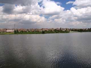
Santa María del Lago is a wetland, part of the Wetlands of Bogotá, located in the locality Engativá, Bogotá, Colombia. The wetland on the Bogotá savanna covers an area of 12 hectares, of which 4 hectares water.

Tibabuyes

Tibabuyes or Juan Amarillo Wetland is a wetland, part of the Wetlands of Bogotá, located in the localities Suba and Engativá, Bogotá, Colombia. The wetland, in the Juan Amarillo River basin on the Bogotá savanna is the largest of the wetlands of Bogotá and covers an area of 222 hectares.

Fucha River

The Fucha River is a river on the Bogotá savanna and a left tributary of the Bogotá River. The river originates in the Eastern Hills of the Colombian capital Bogotá and flows westward through the city into the Bogotá River. It is one of the three important rivers of the city, together with the Tunjuelo and Juan Amarillo Rivers.

Tibanica

Tibanica is a wetland, part of the Wetlands of Bogotá, located on the border of the locality Bosa, Bogotá and Soacha, Cundinamarca, Colombia. The wetland on the Bogotá savanna covers an area of about 28.8 hectares. Tibanica is located in the Tunjuelo River basin.

El Salitre (wetland)

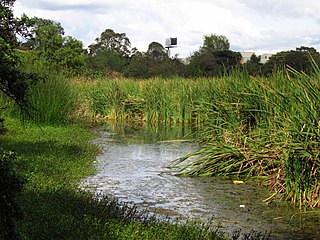
El Salitre is a small wetland, one of the wetlands of Bogotá. It is located within Salitre Park, close to Salitre Mágico, an amusement park north of Simón Bolívar Park in the locality Barrios Unidos of the Colombian capital Bogotá. The area of El Salitre is 6.4 hectares.

La Isla (wetland)

La Isla is a small wetland, part of the wetlands of Bogotá. It is located next to the Tunjuelo River in the locality Bosa, Bogotá, Colombia. The Bogotá River passes 800 metres (2,600 ft) south of the wetland with an area of 7.7 hectares.

Meandro del Say

Meandro del Say is a wetland, part of the wetlands of Bogotá. It spans the locality Fontibón of Bogotá and the eastern part of Mosquera, Cundinamarca. Meandro del Say is located close to the Bogotá River with a total area of 13.6 hectares. The Avenida Centenario borders the wetland in the northeast. Meandro de Say is situated in the Fucha River basin.

La Florida (wetland)

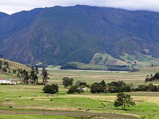
La Florida is a wetland and park known as the Parque Metropolitano La Florida. La Florida is located across the Bogotá River from Jaboque wetland in the municipality Funza, Cundinamarca, close to Cota. La Florida does not belong to the protected wetlands of Bogotá.

Guaymaral y Torca

Guaymaral y Torca is a combined wetland, part of the Wetlands of Bogotá, located in the north of the Colombian capital in the localities Suba and Usaquén, Bogotá, Colombia. The wetlands on the Bogotá savanna cover an area of about 73 hectares. Guaymaral y Torca, the northernmost wetlands of Bogotá at the foot of the Eastern Hills, is composed of three parts, Guaymaral in the west in Suba, Torca in the east in Usaquén and a small strip along the dividing Autopista Norte between the two main wetlands. The wetlands are located in the Torca River basin. The Autopista Norte was constructed in 1952, dividing the wetlands.

Arzobispo River

The Juan Amarillo, Arzobispo, or Salitre River is a river on the Bogotá savanna and a left tributary of the Bogotá River in Colombia. The river originates from various quebradas in the Eastern Hills and flows into the Bogotá River at the largest of the wetlands of Bogotá, Tibabuyes, also called Juan Amarillo Wetland. The total surface area of the Juan Amarillo basin, covering the localities Usaquén, Chapinero, Santa Fe, Suba, Barrios Unidos, Teusaquillo, and Engativá, is 12,892 hectares. Together with the Fucha and Tunjuelo Rivers, the Juan Amarillo River forms part of the left tributaries of the Bogotá River in the Colombian capital.

Torca River

The Torca River is a river on the Bogotá savanna and a left tributary of the Bogotá River. The river, in a basin of 6,008.69 hectares (23.1997 sq mi), originates in the Eastern Hills of Bogotá at an altitude of 2,837 metres (9,308 ft). It flows in the north of the Colombian capital, through the locality of Usaquén and into the Bogotá River in Suba at the border with Chía, at 2,545 metres (8,350 ft) above sea level. The Torca wetland is located near its mouth.

References

  1. 1 2 (in Spanish) Humedal del Techo
  2. Moreno et al., s.a., p.15
  3. (in Spanish) Humedal La Vaca o Techovita website
  4. Moreno et al., s.a., p.16
  5. Andrade & Benitez, s.a., p.8
  6. Andrade & Benitez, s.a., p.11

Bibliography