Afghanistan is a landlocked mountainous country located at the crossroads of Central and South Asia. It is also sometimes included as part of the Middle East. The country is the 40th largest in the world in size. Kabul is the capital and largest city of Afghanistan, located in the Kabul Province. Strategically located at the crossroads of major trade routes, Afghanistan has attracted a succession of invaders since the sixth century BCE.

Transport in Afghanistan has steadily improved in the last decade. Much of the nation's road network was built during the 1960s but left to ruin during the 1980s and 90s wars. New national highways, roads, and bridges have been rebuilt in the last decade to help increase travel as well as trade with neighboring countries. In 2008, there were about 700,000 vehicles registered in Kabul.

The Sangre de Cristo Range is a mountain range of the Rocky Mountains in southern Colorado in the United States, running north and south along the east side of the Rio Grande Rift. The mountains extend southeast from Poncha Pass for about 75 mi (121 km) through south-central Colorado to La Veta Pass, approximately 20 mi (32 km) west of Walsenburg, and form a high ridge separating the San Luis Valley on the west from the watershed of the Arkansas River on the east. The Sangre de Cristo Range rises over 7,000 ft (2,100 m) above the valleys and plains to the west and northeast.
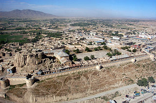
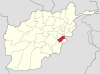
Gardez is the capital of the Paktia Province of Afghanistan. The population of the city was estimated to be ca. 10,000 in the 1979 census and was estimated to be 70,000 in 2008. The majority of the city's native population is Tajik. But recently, with the migration of Pashtun tribes from different parts of Paktia to this city, Pashtuns have taken over the majority of the population of this city. The city of Gardez is located at the junction between two important roads that cut through a huge alpine valley. Surrounded by the mountains and deserts of the Hindu Kush, which boil up from the valley floor to the north, east and west, it is the axis of commerce for a huge area of eastern Afghanistan and has been a strategic location for armies throughout the country's long history of conflict. Observation posts built by Alexander the Great are still crumbling on the hilltops just outside the city limits. The city of Gardez has a population of 70,641. It has 13 districts and a total land area of 6,174 hectares (23.84 sq mi). The total number of dwellings in this city is 7,849.
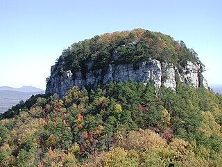
Pilot Mountain, a metamorphic quartzite monadnock rising to a peak 2,421 feet (738 m) above sea level, is one of the most distinctive natural features in the U.S. state of North Carolina. It is a remnant of the ancient chain of Sauratown Mountains. The Saura Native Americans, the region's earliest known inhabitants, called the mountain "Jomeokee", meaning "great guide".

Logar is one of the 34 provinces of Afghanistan located in the eastern section of the country. It is divided into seven districts and contains hundreds of villages. Puli Alam is the capital of the province.
Paktia is one of the 34 provinces of Afghanistan, located in the east of the country. Forming part of the larger Loya Paktia region, Paktia Province is divided into 15 districts and has a population of roughly 623,000, which is mostly a tribal society living in rural areas. Pashtuns make up the majority of the population but smaller number of Tajiks are also found. Gardez is the provincial capital.

Maidan Wardak Province, also called Maidan Wardag or Wardak, is one of the 34 provinces of Afghanistan, located in the central region of Afghanistan. It is divided into eight districts and has a population of approximately 671,817. The capital of the province is Maidan Shar, while the most populous district in the province is Saydabad District.

Middle Park is a high basin in the Rocky Mountains of north-central Colorado in the United States. It is located in Grand County, on the southwest slope of Rocky Mountain National Park, approximately 50 miles (80 km) west of Boulder.

The Kabul River, the classical Cophen, is a 700-kilometre-long (430 mi) river in South Asia that emerges in the Sanglakh Range of the Hindu Kush mountains in Afghanistan, and is separated from the watershed of the Helmand River by the Unai Pass. The Kabul River empties into the Indus River near Attock, Pakistan. It is the main river in eastern Afghanistan and the Khyber Pakhtunkhwa province of Pakistan.
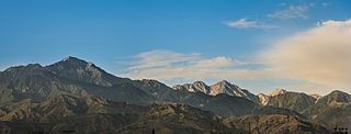
The White Mountains is a mountain range in South Asia to the south of the Hindu Kush. It ranges from eastern Afghanistan into Khyber Pakhtunkhwa, Pakistan. Its highest peak is Mount Sikaram on the Afghanistan–Pakistan border, which towers above all surrounding hills to 4,755 m (15,600 ft) above mean sea level. The lower hills are mostly barren and treeless, but pine grows on the main mountains that form the East Afghan montane conifer forests.

The Tirah also spelled Terah, Tira, Tera region, also called the Tirah Valley, is located in Khyber, Kurram and Orakzai agencies in the Khyber Pakhtunkhwa province of Pakistan, while its smaller part straddles the border to the north lying in Nangarhar Province, Afghanistan. Tirah lies between the Khyber Pass and the Khanki Valley. It is inhabited by the Afridi, Orakzai and Shinwari tribes of Pashtuns.
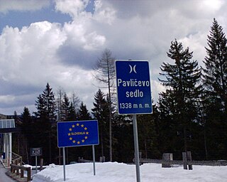
The Pavlič Pass, Paulitsch Pass or Paulitsch Saddle or just Pavlič is a mountain pass that connects the Slovenian municipality of Solčava in the historical region of Lower Styria with the Austrian state of Carinthia.
The following lists events that happened during 1929 in Afghanistan. The Afghan Civil War continued from the previous year.
Khokhi District is located in the East part of Logar Province, Afghanistan. 80 km away from Kabul and 18 km from Pul-i-Alam centre of Logar Province. Centre of the district is called Khoshi. Pashtuns make up 65% of the population, Tajiks 34% and Hazara 1%.
Atiqullah Ludin was the Governor of Logar Province, Afghanistan in 2008–2013. He is originally from Mohammad Agha District of Logar.

The Khost-Gardez Pass, frequently abbreviated as the K-G Pass, and known locally as the Seti-Kandow Pass, or the Satukandav Pass by Soviet forces, is the main land route connecting Khost, the capital of Khost Province, and Gardez, the capital of Paktia province, in eastern Afghanistan. The pass currently consists of a rutted dirt road, though it is slowly being improved by construction crews as part of the international reconstruction effort in Afghanistan.

Spruce Mountain, in eastern West Virginia, USA, is the highest ridge of the Allegheny Mountains. The "whale-backed" ridge extends for only about 16 miles (26 km), from northeast to southwest, but several of its peaks exceed 4,500 feet (1,400 m) in elevation. The summit, Spruce Knob, is celebrated as the highest point in the state as well as the range, which covers parts of four states.

Alanngorsuaq is a 411-metre-high (1,348 ft) mountain in the Qeqqata municipality in western Greenland. It is located on the mainland of Greenland in Sisimiut valley, approximately 3 km (1.9 mi) east of the town.
The geology of Afghanistan includes nearly one billion year old rocks from the Precambrian. The region experienced widespread marine transgressions and deposition during the Paleozoic and Mesozoic, that continued into the Cenozoic with the uplift of the Hindu Kush mountains.