
Leek is a market town and civil parish in Staffordshire, England, on the River Churnet 10 miles (16 km) north east of Stoke-on-Trent. It is an ancient borough and was granted its royal charter in 1214.

Bollington is a town and civil parish in Cheshire, England, to the east of Prestbury. In the Middle Ages, it was part of the Earl of Chester's manor of Macclesfield and the ancient parish of Prestbury. In 2011, it had a population of 8,310.

Congleton is a market town and civil parish in the unitary authority of Cheshire East in Cheshire, England. It is on the River Dane, 21 miles (34 km) south of Manchester and 13 miles (21 km) north of Stoke on Trent. At the 2021 census, it had a population of 30,015.
The River Dane is a tributary of the River Weaver that originates in the Peak District area of England. The name of the river is probably from the Old Welsh dafn, meaning a "drop or trickle", implying a slow-moving river.

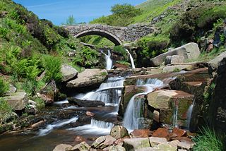
The Roaches is a prominent rocky ridge above Leek and Tittesworth Reservoir in the Staffordshire Peak District of England. The ridge with its rock formations rises steeply to 505 m (1,657 ft).

Biddulph is a town in Staffordshire, England, 8.5 miles (14 km) north of Stoke-on-Trent and 4.5 miles (7 km) south-east of Congleton, Cheshire.
Staffordshire Moorlands is a local government district in Staffordshire, England. Its council is based in Leek, the district's largest town. The district also contains the towns of Biddulph and Cheadle, along with a large rural area containing many villages. North-eastern parts of the district lie within the Peak District National Park.

The Macclesfield Canal is a canal in east Cheshire, England. There were various proposals for a canal to connect the town of Macclesfield to the national network from 1765 onwards, but it was not until 1824 that a scheme came to fruition. There were already suggestions by that date that a railway would be better, but the committee that had been formed elected for a canal and the engineer Thomas Telford endorsed the decision. The canal as built was a typical Telford canal, constructed using cut and fill, with numerous cuttings and embankments to enable it to follow as straight a course as possible, although Telford had little to do with its construction, which was managed by William Crosley.

Congleton railway station is a mainline station serving the Cheshire market town of Congleton. It lies on the Stafford-Manchester branch of the West Coast Main Line in the United Kingdom.

Bosley is a village and civil parish in Cheshire, England. At the 2001 census, it had a population of 406. The village is on the A523 road near to where it intersects the A54, about six miles south of Macclesfield. It is the site of Bosley Reservoir. The Macclesfield Canal runs through the parish. All its locks are in this section, including the noted Bosley Lock Flight.

Bosley Lock Flight is a flight of twelve canal locks, situated on the Macclesfield Canal at Bosley, near Macclesfield, Cheshire, England. The locks are substantially built with stone blocks, and unusually for narrow locks have mitre gates at both ends. They were each built with a side pond, which enabled some of the water to be re-used during a filling and emptying cycle. The side ponds have been disused for many years, but there are plans to reinstate one of them for demonstration purposes.
The Forest of Lyme is a former, mainly elm tree, forest in the present day counties of Cheshire, Staffordshire and parts of Derbyshire. Parts of the forest remain and its name is preserved in many local place-names.

The A536 road links the Cheshire towns of Congleton and Macclesfield.

BakerBus was the trading name used by the bus fleet of Bakers Coaches, a bus and coach operator based in Biddulph, Staffordshire, England. Formed as a coach operator in 1936, they grew to operate a fleet of around 50 vehicles on local bus services and coach hire work, but after several changes of ownership, ceased operation in 2018.

Bosley Minn is one of two names – the other being Wincle Minn – given to a prominent hill in southeast Cheshire and in the southwestern corner of the Peak District National Park in northern England. The long axis of the Minn runs NNE–SSW and its broad summit, which reaches to 386 metres (1,266 ft) at its highest point, slopes away to the valley of the Shell Brook in the east and towards Bosley Reservoir in the west. It is the western aspect of the hill, facing Bosley which is known as Bosley Minn whilst the eastern side which faces the village of Wincle is referred to as Wincle Minn.

A double sunset is a rare astro-geographical phenomenon, in which the Sun appears to set twice in the same evening from a specific viewing-point. A double sunrise may also occur in a similar situation. Such phenomena may have been regarded as significant in prehistoric times, and double sunsets have been discussed in the context of archaeoastronomy by researchers such as Alexander Thom.
Rushton is a civil parish in Staffordshire, England. The village within the civil parish, usually known as Rushton Spencer, is about 4 miles (6.4 km) north of Leek and 7 miles (11 km) south of Macclesfield, on the A523 road which runs between these towns.

The Stoke-on-Trent Green Belt is a green belt environmental and planning policy that regulates the rural space throughout mainly the West Midlands region of England. It is contained within the counties of Cheshire and Staffordshire. Essentially, the function of the designated area is to prevent surrounding towns and villages within the Stoke-on-Trent conurbation from further convergence. It is managed by local planning authorities on guidance from central government.
The Biddulph Valley line was a double tracked line that ran from Stoke-on-Trent to Brunswick Wharf in Congleton. The line was named after the town of the same name as it ran via the Staffordshire Moorlands and covered areas of East Staffordshire and Cheshire.

The Dane Valley Way is a long-distance footpath through Derbyshire, Staffordshire and Cheshire, England. It runs from the Pavilion Gardens in Buxton to the end of the River Dane, where it enters the River Weaver in Northwich.


