Tolchester, Maryland | |
---|---|
Coordinates: 39°13′22″N76°14′19″W / 39.22278°N 76.23861°W Coordinates: 39°13′22″N76°14′19″W / 39.22278°N 76.23861°W | |
Country | United States |
State | Maryland |
County | Kent |
Area | |
• Total | 0.62 sq mi (1.60 km2) |
• Land | 0.61 sq mi (1.58 km2) |
• Water | 0.01 sq mi (0.01 km2) |
Elevation | 26 ft (8 m) |
Population (2020) | |
• Total | 297 |
• Density | 486.89/sq mi (187.90/km2) |
Time zone | UTC−5 (Eastern (EST)) |
• Summer (DST) | UTC−4 (EDT) |
Area code(s) | 410 & 443 |
FIPS code | 24-78120 |
GNIS feature ID | 595180 [2] |
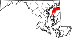
Tolchester is a census-designated place in Kent County, Maryland, United States. [2] Its population was 329 as of the 2010 census. [3] The CDP covers the unincorporated community commonly known as Tolchester Beach.
Historical population | |||
---|---|---|---|
Census | Pop. | %± | |
2020 | 297 | — | |
U.S. Decennial Census [4] |
The United States Census Bureau (USCB), officially the Bureau of the Census, is a principal agency of the U.S. Federal Statistical System, responsible for producing data about the American people and economy. The Census Bureau is part of the U.S. Department of Commerce and its director is appointed by the President of the United States.
Kent County is a county located in the U.S. state of Maryland. As of the 2020 census, its population was 19,198, making it the least populous county in Maryland. Its county seat is Chestertown. The county was named for the county of Kent in England. The county is located on Maryland's Eastern Shore. It is one of three counties in Maryland, along with Caroline and Garrett, that is not part of a Metropolitan Statistical Area.
The United States had an official resident population of 331,893,745 on July 1, 2021, according to the U.S. Census Bureau. This figure includes the 50 states and the District of Columbia but excludes the population of five unincorporated U.S. territories as well as several minor island possessions. The United States is the third most populous country in the world. The Census Bureau showed a population increase of 0.8% for the twelve-month period ending in July 2012. Though high by industrialized country standards, this is below the world average annual rate of 1.1%. The total fertility rate in the United States estimated for 2020 is 1.638 children per woman, which is below the replacement fertility rate of approximately 2.1.
In the United States, a metropolitan statistical area (MSA) is a geographical region with a relatively high population density at its core and close economic ties throughout the area. Such regions are neither legally incorporated as a city or town would be, nor are they legal administrative divisions like counties or separate entities such as states; because of this, the precise definition of any given metropolitan area can vary with the source. The statistical criteria for a standard metropolitan area were defined in 1949 and redefined as metropolitan statistical area in 1983. A typical metropolitan area is centered on a single large city that wields substantial influence over the region. However, some metropolitan areas contain more than one large city with no single municipality holding a substantially dominant position. MSAs are defined by the U.S. Office of Management and Budget (OMB) and used by the Census Bureau and other federal government agencies for statistical purposes.
Betterton is a town in Kent County, Maryland, United States. The population was 345 at the 2010 census.
A census-designated place (CDP) is a concentration of population defined by the United States Census Bureau for statistical purposes only. CDPs have been used in each decennial census since 1980 as the counterparts of incorporated places, such as self-governing cities, towns, and villages, for the purposes of gathering and correlating statistical data. CDPs are populated areas that generally include one officially designated but currently unincorporated community, for which the CDP is named, plus surrounding inhabited countryside of varying dimensions and, occasionally, other, smaller unincorporated communities as well. CDPs include small rural communities, edge cities, colonias located along the Mexico–United States border, and unincorporated resort and retirement communities and their environs.
The United States census of 2000, conducted by the Census Bureau, determined the resident population of the United States on April 1, 2000, to be 281,421,906, an increase of 13.2 percent over the 248,709,873 people enumerated during the 1990 census. This was the twenty-second federal census and was at the time the largest civilly administered peacetime effort in the United States.
The United States census of 1990, conducted by the Census Bureau, was the first census to be directed by a woman, Barbara Everitt Bryant. It determined the resident population of the United States to be 248,709,873, an increase of 9.8 percent over the 226,545,805 persons enumerated during the 1980 census.
The United States census of 1980, conducted by the Census Bureau, determined the resident population of the United States to be 226,545,805, an increase of 11.4 percent over the 203,184,772 persons enumerated during the 1970 census. It was the first census in which a state – California – recorded a population of 20 million people, as well as the first in which all states recorded populations of over 400,000.
The United States census of 1880 conducted by the Census Bureau during June 1880 was the tenth United States census. It was the first time that women were permitted to be enumerators. The Superintendent of the Census was Francis Amasa Walker. This was the first census in which a city—New York City—recorded a population of over one million.
The United States census of 1920, conducted by the Census Bureau during one month from January 5, 1920, determined the resident population of the United States to be 106,021,537, an increase of 15.0 percent over the 92,228,496 persons enumerated during the 1910 census.
The United States census of 1960, conducted by the Census Bureau, determined the resident population of the United States to be 179,323,175, an increase of 18.5 percent over the 151,325,798 persons enumerated during the 1950 census. This was the first census in which all states recorded a population of over 200,000. This census's data determined the electoral votes for the 1964 and 1968 presidential elections. This is also the last census in which New York was the most populous state.
The United States Census of 1970, conducted by the Census Bureau, determined the resident population of the United States to be 203,392,031, an increase of 13.4 percent over the 179,323,175 persons enumerated during the 1960 Census. This was the first census since 1800 in which New York was not the most populous state – California overtook it in population in November 1962. This was also the first census in which all states recorded a population of over 300,000, and the first in which a city in the geographic South recorded a population of over 1 million (Houston).
Tolchester Beach is an unincorporated community located on the eastern shore of the Chesapeake Bay in Kent County, Maryland, United States. Established in 1877, it was formerly a popular resort. Tolchester Beach is located just north of Rock Hall. The resort was closed in 1962.
Americans are the citizens and nationals of the United States of America. Although direct citizens and nationals make up the majority of Americans, many dual citizens, expatriates, and permanent residents could also legally claim American nationality. The United States is home to people of many racial and ethnic origins; consequently, American culture and law do not equate nationality with race or ethnicity, but with citizenship and an oath of permanent allegiance.
Georgetown is an unincorporated community and census-designated place in western Kent County, Maryland, United States. Its population was 143 as of the 2010 census. It should not be confused with the community of the same name 22 miles (35 km) to the northeast on the Kent/Cecil County border.