Tourism in Sardinia

Last updated

Tourism in Sardinia
Spiaggia La Caletta.JPG
Time zone UTC+1 (Central European Time)
Area code +39
Website Sardegnaturismo Official page

Sardinia is the second-largest island in the Mediterranean Sea (after Sicily and before Cyprus) and an autonomous region of Italy. Tourism in Sardinia is one of the fastest growing sectors of the regional economy. The island attracts more than a million tourists from both Italy (particularly from Lombardy, Piedmont, and Lazio), from the rest of Europe (especially from Germany and France), and, to a lesser degree, from the rest of the world. According to statistics, tourist arrivals in 2016 were 2.9 million people. [1]

Contents

American travel magazine Travel + Leisure include Sardinia and Costa Smeralda in 50 Best Places to Travel in 2022. [2]

History

View of Porto Cervo Porto cervo 1.JPG
View of Porto Cervo

Modern tourism in Sardinia began in 1948, when the first investments and development plans were started in conjunction with the acquisition of autonomous region status and the definitive defeat of malaria along the coast. The first promotions and infrastructural achievements were implemented through the Sardinian Tourism Industries Organization (ESIT), which promoted and financed the construction of hotels, including the Miramar Hotel in Alghero (1953).

The growth of the tourism industry began in the early 1960s, when Porto Cervo [3] was founded by the Aga Khan in Costa Smeralda at the municipality of Arzachena, [4] which became the symbol of tourism development for the island. Architects such as Luigi Vietti, Michele Busiri Vici and Jacques Couelle contributed to the realization of the various developments. Porto Cervo was soon followed by Porto Rotondo, [5] Romazzino, Cala di Volpe and Porto Raphael. As Costa Smeralda [6] became more established among the international jet set, the race for the construction of tourist resorts began in many coastal towns on the island.

A myriad of other nearby developments with similar offerings followed, such as Baja Sardinia and Liscia di Vacca. The sector developed in the rest of Sardinia as well, until it became one of the main sectors of the island's economic activities.

Sardinian territories

The island is subdivided into several historical regions, rich in history and traditions and sometimes different languages. Here are the most well-known ones:

South

Cagliaritano, Trexenta, Marmilla, Sarcidano, Sarrabus

View of Cagliari Cagliari-Molentargius-Poetto-Quartu.jpg
View of Cagliari

Cagliari [7] is the capital of the region and the largest city on the island. It has ancient origins, as it was founded by the Phoenicians on previous Nuragic sites. Later occupation by Punics and the Romans left many archaeological finds, including the Tuvixeddu necropolis and the amphitheater, which could accommodate up to 10,000 people. Numerous coastal ponds surround the city, like the Molentargius - Saline Regional Park, located between the urban area and Poetto Beach. These wetlands are very important for the reproduction of water birds such as the greater flamingo.

In the Sarrabus-Gerrei area, the beaches of Costa Rei [8] extend to the foot of the hills of Capo Ferrato; [9] they are considered to be among the most beautiful in the world by Lonely Planet, along with those of Villasimius [10] farther south. [11] To the southwest of Cagliari, the main tourist resorts are located in the town of Pula, [12] which also houses the ruins of the ancient city of Nora. [13]

The Marmilla and Sarcidano regions have several important archaeological sites and landscapes such as the Giara di Gesturi. [14] At Barumini is the site of Su Nuraxi, [15] a UNESCO heritage site, one of the most visited historic sites on the island. In the commune territory of Orroli, there are the ruins of Nuraghe Arrubiu. [16] These territories and nearby Trexenta are traversed by the Trenino Verde, [17] a tourism railway line.

Sulcis, Iglesiente, Monreale

Chia Chia beach, Sardinia, Italy.jpg
Chia

The southwest part of Sardinia is the Sulcis region and includes the islands of San Pietro [18] and Sant'Antioco, [19] which have the peculiarity of hosting Ligurian communities (including Carloforte [20] and Calasetta [21] ). The Teulada [22] cape limestone cliffs originated 500 million years ago and are considered to be among the oldest rocks in Europe. In the vicinity of Carbonia, [23] there is the fortress of Monte Sirai, [24] a testimony to the Phoenician-Punic and then Roman domination of the region, which also affected the islands and the littoral below, where the ruins of Sulci, Bithia, Inosim and Pani-Loriga are located, dating from the 8th century BC. The most popular seaside resorts are Porto Pino (Sant'Anna Arresi) and Chia [25] (Domus de Maria).

The Iglesiente, named after the medieval town of Iglesias [26] (founded by the infamous Count Ugolino della Gherardesca), has been an important mining district; abandoned mines are an example of mining architecture and industrial archeology. In the municipality of Fluminimaggiore is the temple of Antas, [27] from Punic Roman times.

Another notable spot is the sand dunes of Piscinas [28] (Arbus), in the Costa Verde, [29] where golden sand dunes penetrate 3 kilometers into the interior, forming a miniature desert. The dunes are active and moved by the wind. Twisted junipers grow in the desert boundary areas, and the Mediterranean scrub is inhabited by animals that include the Sardinian deer.

Center

Barbagia, Goceano, Baronie and Ogliastra

Cala Goloritze Cala Coloritze vom Land.JPG
Cala Goloritzé

Barbagia is the region that represents the heart of Sardinia; it surrounds around the Gennargentu [30] massif [31] and Supramonte [32] highland, a chain of granite, shale and limestone mountains that reaches the eastern coast from the inner parts of the island and descends to the sea between Dorgali and Baunei. The town of Nuoro [33] is the main urban center, while Fonni [34] is a winter sports center with a ski lift to Monte Spada and Bruncu Spina ski area.

Goceano, inland mountainous territory, is instead known above all for the castle of Burgos, [35] one of the many medieval castles in Sardinia. The main urban centres are Bono [36] with Italy's most expansive yew tree forest Sos Nibberos, [37] considered the traditional Goceano's chieftown, Anela, [38] the oldest village of Goceano with in its vicinity Forest'Anela [39] for trekking tourism and Necropolis of Sos Furrighesos, [40] Benetutti, [41] Burgos, [42] Bultei, [43] Nule, [44] Esporlatu, [45] Illorai [46] and Bottidda. [47]

The main tourist attractions of the coastal region of the Baronie are Orosei, [48] Posada [49] and Siniscola. [50] In Ogliastra, the main tourist locations include Arbatax-Tortolì, [51] Santa Maria Navarrese, [52] Lotzorai, [53] Bari Sardo [54] and Cardedu. [55]

Sinis, Marghine, Montiferru, Planargia, Barigadu

San Giovanni di Sinis Le spiaggie di San Giovanni di Sinis. - panoramio.jpg
San Giovanni di Sinis

Tharros [56] was founded by the Phoenicians, but on previous Nuragic villages; it was inhabited for 1,800 years before being abandoned. The port's ruins are impressive, but only a small part of its actual extent has been excavated. In the Sinis peninsula, where the Giants of Monte Prama [57] were discovered, there are sandy beaches such as Is Arutas and Mari Ermi.

Oristano [58] flourished between the years 1100 and 1400, during the period of the Giudicato of Arborea. Inside the ancient walls remain the Tower of San Cristoforo or of Marianus II of Arborea and the opposite, Portixedda. The cathedral and the churches of San Francesco and Santa Chiara are located in the historic center, near the Eleonora of Arborea square. Just outside Oristano, there is the pond of Cabras [59] and the nearby lagoon of Mistras, [60] where thousands of cormorants and flamingos, as well as ducks, coots, white herons, western swamphen and black-winged stilt live seasonally.

The main tourist resort of the Planargia is the town of Bosa [61] with the Castle of Serravalle. [62] The Marghine, which has Macomer as its main center, is one of the Sardinian territories with the highest concentration of Nuragic sites. In the Barigadu region, one of the most visited sites is the ruins of the Roman baths in the territory of Fordongianus [63] (the former Forum Traiani). [64]

North

Gallura

Caprera Il faro di Capo Ferro visto dalla spiaggia del Relitto (Caprera) - panoramio.jpg
Caprera

Gallura is a territory that occupies the whole northeastern part of Sardinia, including the Maddalena archipelago [65] and the island of Caprera, [66] where Giuseppe Garibaldi spent his last years and where he is buried. It is a mountain region, with few flat areas (the Olbia plain) dominated by the polished granite shapes and the dark green of the Mediterranean scrub. Monti [67] is a notable center, is known for its vineyards producing the local vermentino wine.

In the Costa Smeralda, and farther south in Budoni [68] and San Teodoro, [69] much of the island's tourism is concentrated, [70] but there are also completely wild areas, such as the vast territories of Alà dei Sardi [71] and Buddusò, [72] easily reachable from the coast. All coastal communes are renowned tourist resorts, while the communes of the interior are rich in precious remnants of the Nuragic civilization, dolmen, menhirs and sacred wells, as well as characteristic mountain villages (such as Aggius) [73] and natural features, including the ancient olive trees of Santu Baltolu in Luras. [74]

Algherese, Riviera del Corallo, Porto Torres, Golfo dell'Asinara, Romangia, Logudoro, Anglona, Meilogu

View of Alghero Alghero dal lungomare - panoramio.jpg
View of Alghero

Alghero [75] and the Riviera del Corallo, Porto Torres, [76] Asinara, [77] Argentiera [78] and Stintino [79] are well known locations. Alghero, a tourist-oriented city and Catalan linguistic island, has numerous beaches and a vast and varied naturalistic heritage with a historic center that can be considered a museum in itself. The surrounding area is also rich in monuments and museums recording its history. The Alghero territory is also known as the Riviera del Corallo and the Neptune's grotto. [80] The coasts around Capo Caccia [81] and its submerged caves are another well known site.

Farther north are the ghost town of Argentiera [82] and the port city of Porto Torres, [83] with the island of Asinara [84] and its national park, the important Roman vestiges of the ancient city of Turris Libisonis, countless archaeological sites located throughout its territory, as well as the majestic Basilica of San Gavino, former cathedral of the Roman Catholic Archdiocese of Sassari and one of the first manifestations of Romanesque architecture in Sardinia. A nearby beach is Balai, and Stintino has famous beaches such as La Pelosa. [85] Castelsardo [86] has a medieval castle, a medieval village and the picturesque beaches of Lu Bagnu. This area includes many other places of interest such as Sassari, [87] Sardinia's second city by population, with its historic center, archaeological sites (such as the megalithic altar of Monte d'Accoddi), [88] Platamona, [89] Sedini, [90] Tergu [91] and Valledoria. [92]

In the Logudoro hinterland, in addition to the Pre-Nuragic and Nuragic vestiges (including the Dolmen of Sa Coveccada [93] and the nuraghe Santu Antine) there are numerous Romanesque churches, such as the basilica of Saccargia of Codrongianos, built in the 11th or 12th century in Romanesque-Pisan style by the judges of Torres, the basilica of Sant'Antioco di Bisarcio in Ozieri [94] and the church of Santa Maria del Regno of Ardara. [95]

The most beautiful villages in Italy

Castelsardo Castelsardo 36DSC 0401.jpg
Castelsardo

In the classification of the cultural community of The most beautiful villages in Italy , Sardinia appears with 9 certified villages among the best in the country for conservation of the territory and artistic heritage, in addition to adequate cultural enhancemen. [96]

Site Unesco

Su Nuraxi in winter Il Nuraghe Su Nuraxi incantato " Tra Fiaba e Realta " 01.JPG
Su Nuraxi in winter

Su Nuraxi is a nuragic archaeological site in Barumini, Sardinia, Italy. Su Nuraxi simply means "The Nuraghe" in Campidanese, the southern variant of the Sardinian language.

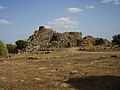
Su Nuraxi is a settlement consisting of a seventeenth century BC Nuraghe, a bastion of four corner towers plus a central one, and a village inhabited from the thirteenth to the sixth century BC, developed around the Nuraghe. They are considered by scholars the most impressive expression of the Nuragic civilization and were included in the UNESCO list of World Heritage Sites in 1997 as Su Nuraxi di Barumini.

Mountain and ecotourism tourism

Sardinia has three national parks and several regional parks, nature reserves and minor oases. The territory represents an important resource for Sardinia. With the framework law n. 31 of 7 June 1989 [97] the purposes and methods for establishing and managing the natural areas to be protected were defined, identifying 8 regional parks, 60 protected areas, 24 natural monuments and 16 areas of relevant naturalistic interest. To these areas are added the oases (protected area)|WWF oases, an organization that has been actively present on the island for some time.

Food and wine tourism

The Sardinian cuisine is characterized by its variety, as well as by having been enriched in history through contributions and contaminations from contacts and exchanges between different European and Mediterranean cultures. Varied and diversified, it ranges from roasted meats to bread, cheeses, wines, [98] to sea and land dishes, both of peasant and pastoral origin, game, fishing and the collection of wild herbs. It is considered part of the Mediterranean diet, a nutritional model proclaimed in 2010 by UNESCO among the oral and intangible heritages of humanity. [99]

See also

Notes

  1. Agenzia Nazionale Stampa Associata, "Turismo: 2,9mln arrivi in Sardegna 2016" (in Italian)
  2. "The 50 Best Places to Travel in 2022".
  3. "Porto Cervo". 25 July 2016.
  4. "Arzachena". 20 November 2015.
  5. "Porto Rotondo". 23 August 2016.
  6. "The Emerald Coast". 4 December 2015.
  7. "Cagliari". 23 November 2015.
  8. "Costa Rei". 20 November 2015.
  9. "Capo Ferrato". 20 November 2015.
  10. "Villasimius". 20 November 2015.
  11. lonelyplanetitalia.it, "Spiagge? Ecco la top 10" (in Italian)
  12. "Pula". 20 November 2015.
  13. "Nora". 20 November 2015.
  14. "Sa Jara Manna – Giara di Gesturi". 20 November 2015.
  15. "Su Nuraxi". 20 November 2015.
  16. SardegnaCultura.it, "Aree archeologiche" (in Italian)
  17. "Great beauty travels on the Green train". 11 July 2018.
  18. "San Pietro". 20 November 2015.
  19. "Sant'Antioco". 20 November 2015.
  20. "Carloforte". 20 November 2015.
  21. "Calasetta". 20 November 2015.
  22. "Teulada". 20 November 2015.
  23. "Carbonia". 20 November 2015.
  24. "Monte Sirai area". 20 November 2015.
  25. "Chia". 5 February 2016.
  26. "Iglesias". 20 November 2015.
  27. "Temple of Antas". 20 November 2015.
  28. "Piscinas". 20 November 2015.
  29. "Costa Verde". 5 February 2016.
  30. "Gennargentu". 5 February 2016.
  31. "The Gennargentu Massif". 20 November 2015.
  32. "Supramonte". 20 November 2015.
  33. "Nuoro". 5 February 2016.
  34. "Fonni". 20 November 2015.
  35. "Castle of Burgos". 20 November 2015.
  36. "Bono". 7 November 2017.
  37. "Sos Nibberos". 20 November 2015.
  38. "Anela". 31 July 2017.
  39. "Forest'Anela". 20 November 2015.
  40. "Domus de Janas di Sos Furrighesos – Anela (SS)".
  41. "Benetutti". 20 November 2015.
  42. "Burgos". 20 November 2015.
  43. "Bultei". 20 November 2015.
  44. "Nule". 20 November 2015.
  45. "Esporlatu". 20 November 2015.
  46. "Illorai". 20 November 2015.
  47. "Bottidda". 20 November 2015.
  48. "Orosei". 20 November 2015.
  49. "Posada". 20 November 2015.
  50. "Siniscola". 20 November 2015.
  51. "Tortolì". 20 November 2015.
  52. "Santa Maria Navarrese". 20 November 2015.
  53. "Lotzorai". 20 November 2015.
  54. "Bari Sardo". 20 November 2015.
  55. "Cardedu". 20 November 2015.
  56. "Ancient city of Tharros". 20 November 2015.
  57. "Sardinia, the land of Giants". 20 September 2018.
  58. "Oristano". 20 November 2015.
  59. "Cabras". 27 March 2017.
  60. "Pond of Cabras". 20 November 2015.
  61. "Bosa". 20 November 2015.
  62. Bosa – Sardegna Turismo
  63. "Fordongianus". 20 November 2015.
  64. Fordongianus | Sardegna Turismo
  65. "La Maddalena, a world unto itself". 4 January 2022.
  66. "Caprera". 20 November 2015.
  67. "Monti". 20 November 2015.
  68. "Budoni". 20 November 2015.
  69. "San Teodoro". 20 November 2015.
  70. Agenzia Nazionale Stampa Associata, "Turismo: crescono presenze, boom stranieri" (in Italian)
  71. "Alà dei Sardi". 20 November 2015.
  72. "Buddusò". 20 November 2015.
  73. "Aggius". 20 November 2015.
  74. "Luras". 20 November 2015.
  75. "Alghero". 20 November 2015.
  76. "Porto Torres". 20 November 2015.
  77. "Asinara". 20 November 2015.
  78. "Argentiera". 22 January 2020.
  79. "Stintino". 20 November 2015.
  80. "Neptune's grotto (Grotta di Nettuno)". 20 November 2015.
  81. "Capo Caccia – Isola Piana". 20 November 2015.
  82. "Argentiera". 22 January 2020.
  83. "Porto Torres". 20 November 2015.
  84. "Asinara". 20 November 2015.
  85. "La Pelosa". 20 November 2015.
  86. "Castelsardo". 20 November 2015.
  87. "Sassari". 20 November 2015.
  88. "Tempio-Altare di monte d'Accoddi". 4 July 2017.
  89. "Platamona". 20 November 2015.
  90. "Sedini". 20 November 2015.
  91. "Tergu". 20 November 2015.
  92. "Marina di Valledoria". 20 November 2015.
  93. "Mores". 20 November 2015.
  94. "Ozieri". 20 November 2015.
  95. "Ardara". 31 July 2017.
  96. "Sardegna" (in Italian). Retrieved 1 August 2023.
  97. "Full text of the Regional Law 7 June 1989, n. 31" . Retrieved 2 October 2010.
  98. Brigaglia, Manlio; Casale, Daniele; Caravano, Lello. "Special itineraries of Bell'Italia: Sardegna, n. 32 – Il Nuorese" (PDF). Editoriale Giorgio Mondadori. Archived from the original (PDF) on 24 December 2013. Retrieved 6 June 2011.
  99. Autonomous Region of Sardinia (ed.). "Unesco: Mediterranean diet; Cappellacci, satisfaction for recognition of agri-food excellences" (PDF). Retrieved 6 June 2011.

Bibliography

Related Research Articles

<span class="mw-page-title-main">Sardinia</span> Island in the Mediterranean and region of Italy

Sardinia is the second-largest island in the Mediterranean Sea, after Sicily, and one of the twenty regions of Italy. It is located west of the Italian Peninsula, north of Tunisia and immediately south of the French island of Corsica.

<span class="mw-page-title-main">Nuraghe</span> Ancient type of tower common in Sardinia

The nuraghe, or nurhag, is the main type of ancient megalithic edifice found in Sardinia, Italy, developed during the Nuragic Age between 1900 and 730 BC. Today it has come to be the symbol of Sardinia and its distinctive culture known as the Nuragic civilization. More than 7,000 nuraghes have been found, though archeologists believe that originally there were more than 10,000.

<span class="mw-page-title-main">Olbia</span> Comune in Sardinia, Italy

Olbia is a city and commune of 60,346 inhabitants in the Italian insular province of Sassari in northeastern Sardinia, Italy, in the historical region of Gallura. Called Olbia in the Roman age, Civita in the Middle Ages and the Terranova Pausania until the 1940s, Olbia has again been the official name of the city since the fascist period.

<span class="mw-page-title-main">Gallura</span>

Gallura is a region in North-Eastern Sardinia, Italy.

<span class="mw-page-title-main">Sassari</span> Second-largest city in Sardinia

Sassari is an Italian city and the second-largest of Sardinia in terms of population with 127,525 inhabitants, and a Functional Urban Area of about 260,000 inhabitants. One of the oldest cities on the island, it contains a considerable collection of art.

<span class="mw-page-title-main">Porto Torres</span> Comune in Sardinia, Italy

Porto Torres is a comune (municipality) and a city of the Province of Sassari in north-west of Sardinia, Italy. Founded during the 1st century BC as Colonia Iulia Turris Libisonis, it was the first Roman colony of the entire island. It is situated on the coast at about 25 kilometres (16 mi) east of Falcone Cape and in the center of the Gulf of Asinara. The port of Porto Torres is the second biggest seaport of the island, followed by the port of Olbia. The town is very close to the main city of Sassari, where the local university takes office.

Alghero is a city of about 45,000 inhabitants in the Italian insular province of Sassari in northwestern Sardinia, next to the Mediterranean Sea. The city's name comes from Aleguerium, which is a mediaeval Latin word meaning "stagnation of algae".

<span class="mw-page-title-main">History of Sardinia</span>

Archaeological evidence of prehistoric human settlement on the island of Sardinia is present in the form of nuraghes and other prehistoric monuments, which dot the land. The recorded history of Sardinia begins with its contacts with the various people who sought to dominate western Mediterranean trade in classical antiquity: Phoenicians, Punics and Romans. Initially under the political and economic alliance with the Phoenician cities, it was partly conquered by Carthage in the late 6th century BC and then entirely by Rome after the First Punic War. The island was included for centuries in the Roman province of Sardinia and Corsica, which would be incorporated into the diocese of Italia suburbicaria in 3rd and 7th centuries.

<span class="mw-page-title-main">Province of Sassari</span> Province of Italy

The province of Sassari is a province in the autonomous island region of Sardinia, Italy. Its capital is the city of Sassari. As of 2017, the province had a population of 493,357 inhabitants.

<span class="mw-page-title-main">Arzachena</span> Town in Sardinia, Italy

Arzachena is a town and comune in the province of Sassari, northern Sardinia, the second largest island off the coast of Italy. Arzachena lies half way between the original Costa Smeralda resort and Porto Rafael, both founded in the late 1950s. After Olbia and Tempio Pausania, it is the third largest commune in Gallura by inhabitants.

<span class="mw-page-title-main">Su Nuraxi (Barumini)</span> Archaeological site in Sardinia, Italy

Su Nuraxi is a nuragic archaeological site in Barumini, Sardinia, Italy. Su Nuraxi simply means "The Nuraghe" in Campidanese, the southern variant of the Sardinian language.

<span class="mw-page-title-main">Stintino</span> Comune in Sardinia, Italy

Stintino is a coastal comune (municipality) in the Province of Sassari in the Italian region Sardinia, located about 200 kilometres (120 mi) north of Cagliari and about 35 kilometres (22 mi) northwest of Sassari.

<span class="mw-page-title-main">Sulcis</span> Geographic region of Sardinia

Sulcis is a subregion of Sardinia, Italy, in the Province of South Sardinia.

<span class="mw-page-title-main">Nurra</span> Geographical region in the northwest of Sardinia, Italy

The Nurra is a geographical region in the northwest of Sardinia, Italy. It is the second-largest plain of the island, located between the towns of Sassari, Porto Torres and Alghero. It covers a surface of 700 km² and is bounded by the Sardinian Sea on the west and by the Gulf of Asinara on the north.

<span class="mw-page-title-main">Nuragic civilization</span> Archaeological culture in Sardinia

The Nuragic civilization, also known as the Nuragic culture, was a civilization or culture on the Mediterranean island of Sardinia, Italy, which lasted from the 18th century BC up to the Roman colonization in 238 BC. Others date the culture as lasting at least until the 2nd century AD and in some areas, namely the Barbagia, to the 6th century AD or possibly even to the 11th century AD.

<span class="mw-page-title-main">Sardinian people</span> Romance ethnic group native to Sardinia

The Sardinians, or Sards, are a Romance language-speaking ethnic group native to Sardinia, from which the western Mediterranean island and autonomous region of Italy derives its name.

<span class="mw-page-title-main">Giants of Mont'e Prama</span> Ancient sculptures in Sardinia (Italy)

The Giants of Mont'e Prama are ancient stone sculptures created by the Nuragic civilization of Sardinia, Italy. Fragmented into numerous pieces, they were discovered in March 1974 on farmland near Mont'e Prama, in the comune of Cabras, province of Oristano, in central-western Sardinia. The statues are carved in local sandstone and their height varies between 2 and 2.5 meters.

Roberta Floris is an Italian journalist, television presenter and former model.

The bay of Porto Conte is a natural inlet on the Riviera del Corallo, a locality on the northwest coast of Sardinia, in the sea of the same name, protected following the establishment of the Porto Conte Regional Nature Park. It is enclosed between the karst promontories of Capo Caccia and Punta Giglio and faces the Alghero roadstead; it is about 20 km from Alghero itself. It measures from the mouth to the bottom 6 km, with a width of about 2.5 km. The coastal part consists of small inlets, cliffs, and the long sandy beach of Mugoni pine forest.