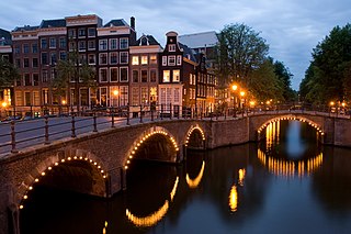
Amsterdam is the capital and most populous city of the Netherlands with a population of 872,680 within the city proper, 1,558,755 in the urban area and 2,480,394 in the metropolitan area. Found within the province of North Holland, Amsterdam is colloquially referred to as the "Venice of the North", attributed by the large number of canals which form a UNESCO World Heritage Site.

North Holland is a province of the Netherlands in the northwestern part of the country. It is located on the North Sea, north of South Holland and Utrecht, and west of Friesland and Flevoland. In November 2019, it had a population of 2,877,909 and a total area of 4,092 km2 (1,580 sq mi), of which 1,430 km2 (550 sq mi) is water.

Amstelveen is a municipality in the province of North Holland, Netherlands with a population of 89,918 (2017). It is a suburban part of the metropolitan area of Amsterdam.

Duivendrecht is a village in the Dutch province of North Holland. It is a part of the municipality of Ouder-Amstel, and lies about 6 km southeast of Amsterdam’s city center. In fact, it is surrounded by Amsterdam.

The Royal Concertgebouw is a concert hall in Amsterdam, Netherlands. The Dutch term "concertgebouw" translates into English as "concert building". Its superb acoustics place it among the finest concert halls in the world, along with Boston's Symphony Hall and the Musikverein in Vienna.
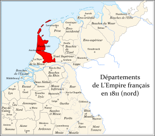
Zuyderzée was a department of the First French Empire in the present-day Netherlands. It is named after the Zuiderzee sea inlet. It was formed in 1810, when the Kingdom of Holland was annexed by France. Its territory corresponded more or less with the present-day Dutch provinces of North Holland and Utrecht. Its capital was Amsterdam.

The Zuidas is a rapidly developing business district in the city of Amsterdam in the Netherlands. The Zuidas is also known as the 'Financial Mile'. It lies between the rivers Amstel and Schinkel along the ringway A10. The greatest influences for the development of the Zuidas are La Défense in Paris and Canary Wharf in London. In size it can best be compared with the Noordruimte/Espace Nord in Brussels.

The coat of arms of Amsterdam is the official coat of arms symbol of the city of Amsterdam. It consists of a red shield and a black pale with three silver Saint Andrew's Crosses, the Imperial Crown of Austria, two golden lions, and the motto of Amsterdam. Several heraldic elements have their basis in the history of Amsterdam. The crosses and the crown can be found as decorations on different locations in the city.

The Zwanenburgwal is a canal and street in the center of Amsterdam. During the Dutch Golden Age the canal was home to painter Rembrandt van Rijn, as well as philosopher Spinoza lived here. In 2006 it was voted one of the most beautiful streets in Amsterdam by readers of Het Parool, a local daily newspaper.
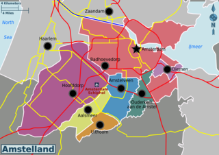
Amstelland is the area along the river Amstel in the Netherlands, beginning in South Holland and running north towards Amsterdam in southern North Holland.

The InterContinental Amstel Amsterdam Hotel, commonly referred to as the Amstel Hotel, is a hotel in Amsterdam, capital city of the Netherlands, on the east bank of the river Amstel.

Amsteldorp is a neighborhood of Amsterdam, Netherlands. The neighborhood dates from the 1920s but many houses were built in 1947-48 and in the 1950s. The Amstel Station is located within this area, which was built in 1939, and the tallest building in the neighbourhood is Rembrandt Tower, with a height of 150 metres.

Amsterdam-Oost is a borough of Amsterdam, Netherlands, established in May 2010 after a merger of the former boroughs of Zeeburg and Oost-Watergraafsmeer. In 2013, the borough had almost 123,000 inhabitants.

Buitenveldert is a neighborhood of Amsterdam, Netherlands. It is considered the modern Jewish quarter of Amsterdam with its Synagogue, Jewish schools, nursing homes, shops and restaurants.
De Pijp is a neighbourhood of Amsterdam, Netherlands. It is located directly south of Amsterdam's city centre and it is part of the borough Amsterdam-Zuid, in a part of the city known as the Old South. It is served by De Pijp metro station. Most streets in De Pijp are named after Dutch painters, like Jan Steen, Frans Hals, Ruysdael and Vincent van Gogh. Diamantbuurt, Nieuwe Pijp and Oude Pijp are the three districts composing the area.

The Grachtengordel is a neighborhood in Amsterdam, Netherlands located in the Centrum district. The seventeenth-century canals of Amsterdam, located in the center of Amsterdam, were added to the UNESCO World Heritage List in August 2010. The Amsterdam Canal District consists of the area around the city's four main canals: the Singel, the Herengracht, the Keizersgracht, and the Prinsengracht. From the Brouwersgracht, the canals are generally parallel with one another, leading gradually southeast into the Amstel river.

Rivierenbuurt is a neighbourhood of Amsterdam, Netherlands. The neighbourhood is situated in the eastern part of the borough of Amsterdam-Zuid, bordered by the river Amstel to the east, the Boerenwetering canal in the west, the Amstelkanaal in the north and the A10 motorway in the south. In 2013, the Rivierenbuurt had approximately 28,400 residents.

Schinkelbuurt is a little neighborhood of Amsterdam, Netherlands. It is located directly south of Amsterdam's city centre and it is part of the borough Amsterdam-Zuid, in the part of the city known as the Old South.
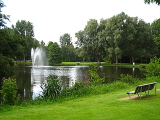
The Amstelpark is a park in Amsterdam-Zuid. The park includes a labyrinth, a café, a restaurant, two galleries, an orangery, a petting zoo and a mini-golf course.

The City Hall in Nieuwer-Amstel is a Neo renaissance building built in 1889-1892 overlooking the Amstel. It was the seat of the city of Nieuwer-Amstel's government, but after absorption into the municipality of Amsterdam in 1896, it became a location for the Amsterdam City Archives in 1914.
