This article needs additional citations for verification .(October 2021) |
 Tropical storm Mujigae near peak intensity on 11 September | |
| Meteorological history | |
|---|---|
| Formed | 8 September 2009 |
| Dissipated | 12 September 2009 |
| Tropical storm | |
| 10-minute sustained (JMA) | |
| Highest winds | 75 km/h (45 mph) |
| Lowest pressure | 994 hPa (mbar);29.35 inHg |
| Tropical depression | |
| 1-minute sustained (SSHWS/JTWC) | |
| Highest winds | 55 km/h (35 mph) |
| Lowest pressure | 998 hPa (mbar);29.47 inHg |
| Overall effects | |
| Fatalities | 11 direct |
| Damage | $14.6 million (2009 USD) |
| Areas affected | Philippines,Hong Kong,China,Vietnam |
| IBTrACS | |
Part of the 2009 Pacific typhoon season | |
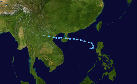
Tropical Storm Mujigae, known in the Philippines as Tropical Depression Maring was a tropical storm that affected the Philippines,China,Hong Kong,and Vietnam in early September 2009. Mujigae originated from an area of convection that developed along with a monsoon trough with favorable conditions on 8 September. The disturbance organized to a tropical depression and was assigned the names 14W by the Joint Typhoon Warning Center and Maring by PAGASA later that day. Tropical Depression 14W would rapidly develop and attain tropical storm status by the JMA and be assigned the name Mujigae on 10 September. Mujigae soon encountered unfavorable conditions with wind shear and make landfall in Hainan Island on 11 September and Vietnam on 12 September before rapidly weakening and dissipating.