Tropical Storm Mujigae (2009)

Last updated

Tropical Storm Mujigae (Maring)
Tropical storm (JMA scale)
Tropical depression (SSHWS)
Tropical Storm Mujigae 2009-09-11.jpg
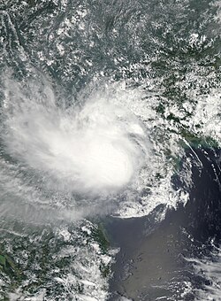
Tropical storm Mujigae near peak intensity on 11 September
Formed8 September 2009
Dissipated12 September 2009
Highest winds 10-minute sustained: 75 km/h (45 mph)
1-minute sustained: 55 km/h (35 mph)
Lowest pressure990 hPa (mbar); 29.23 inHg
Fatalities11 direct
Damage$14.6 million (2009 USD)
Areas affected Philippines, Hong Kong, China, Vietnam
Part of the 2009 Pacific typhoon season

Tropical Storm Mujigae, known in the Philippines as Tropical Depression Maring was a tropical storm that affected the Philippines, China, Hong Kong, and Vietnam in September 2009.

Contents

Meteorological history

Map plotting the storm's track and intensity, according to the Saffir-Simpson scale

Map key
Saffir-Simpson scale
.mw-parser-output .div-col{margin-top:0.3em;column-width:30em}.mw-parser-output .div-col-small{font-size:90%}.mw-parser-output .div-col-rules{column-rule:1px solid #aaa}.mw-parser-output .div-col dl,.mw-parser-output .div-col ol,.mw-parser-output .div-col ul{margin-top:0}.mw-parser-output .div-col li,.mw-parser-output .div-col dd{page-break-inside:avoid;break-inside:avoid-column}
.mw-parser-output .legend{page-break-inside:avoid;break-inside:avoid-column}.mw-parser-output .legend-color{display:inline-block;min-width:1.25em;height:1.25em;line-height:1.25;margin:1px 0;text-align:center;border:1px solid black;background-color:transparent;color:black}.mw-parser-output .legend-text{}
Tropical depression (<=38 mph, <=62 km/h)

Tropical storm (39-73 mph, 63-118 km/h)

Category 1 (74-95 mph, 119-153 km/h)

Category 2 (96-110 mph, 154-177 km/h)

Category 3 (111-129 mph, 178-208 km/h)

Category 4 (130-156 mph, 209-251 km/h)

Category 5 (>=157 mph, >=252 km/h)

Unknown
Storm type
Tropical cyclone
Subtropical cyclone
Extratropical cyclone / Remnant low / Tropical disturbance / Monsoon depression Mujigae 2009 track.png
Map plotting the storm's track and intensity, according to the Saffir–Simpson scale
Map key
  Tropical depression (≤38 mph, ≤62 km/h)
  Tropical storm (39–73 mph, 63–118 km/h)
  Category 1 (74–95 mph, 119–153 km/h)
  Category 2 (96–110 mph, 154–177 km/h)
  Category 3 (111–129 mph, 178–208 km/h)
  Category 4 (130–156 mph, 209–251 km/h)
  Category 5 (≥157 mph, ≥252 km/h)
  Unknown
Storm type
ArrowUp.svg Extratropical cyclone / Remnant low / Tropical disturbance / Monsoon depression

Early on 8 September 2009, the Joint Typhoon Warning Center reported that an area of convection had persisted about 340 km (210 mi) northwest of Manila in the Philippines. [1] The disturbance had a broad low-level circulation center with convection starting to consolidate and was developing along the monsoon trough in favorable conditions. [1] Later that day both the Philippine Atmospheric, Geophysical and Astronomical Services Administration (PAGASA) and the Japan Meteorological Agency (JMA) reported that the disturbance had become a tropical depression with PAGASA assigning the name of Maring to the depression as the low-level circulation center became more developed. [2] [3] The next morning, the JTWC designated the tropical depression as 14W after the system had rapidly consolidated with deep convective bands forming in the low-level circulation center. [4] [5] The depression was steered by a low to mid-level ridge to the northeast, however, a deeper secondary ridge was expected to assume steering the system to the northeast as it moved out of PAGASA's area of responsibility. [4] [6]

During that day, the depression rapidly developed, being changed to a tropical storm status by the JMA early on 10 September. JMA assigned the international number of 0913 and the name Mujigae to the storm. [7] However, at that time, Mujigae's low-level circulation center was partially exposed with convection confined to the western portion of the low-level circulation center due to a moderate amount of vertical wind shear associated with an anticyclone to the northeast of Mujigae. This affected the system which prevented Mujigae from further intensifying. [8] [9] Mujigae then made landfall early the next day and passed over Northern Hainan Island with observations from Meilan, Hainan, showing that Mujigae was a 55 km/h (35 mph) Tropical depression. [10] However, the JMA did not downgrade Mujigae to a tropical depression at this time. [11] As Mujigae moved into the Gulf of Tonkin, the low-level circulation center became less organized with the JTWC forecasting that Mujigae would dissipate within six hours of making landfall on Vietnam. [12] Mujigae then made landfall on Vietnam early on 12 September. [13] The JTWC then issued their last advisory with the JMA downgrading Mujigae to a tropical depression and their final advisory as Mujigae remnants had dissipated. [13] [14] [15]

Preparations and impact

Philippines

When PAGASA issued their first warning on 8 September 2009, they placed the provinces of Ilocos Sur, La Union, Zambales, Bataan, Western Pangasinan, and Lubang Island under Public Storm Warning Signal One. [2] They kept these warnings in force until early the next day, when they cancelled the signals for Bataan and Lubang Island, and placed the whole of Pangasinan as well as Ilocos Norte, Abra under the Public Storm Warning Signal One before cancelling all of the signals later that morning. [16] [17] PAGASA also warned residents living in low-lying areas and near mountain slopes to take all the necessary precautions against possible flash floods and landslides. [2] [6]

In western Luzon, including Manila, a 48-hour rainfall was recorded when the depression was just forming. The depression enhanced the southwest monsoon that brought torrential rains to the area. In Laguna, two children were killed due to landslides caused by torrential rains brought by Maring. Late on 8 September, both the JMA and the PAGASA declared the system was a minor tropical depression. On 9 September, all classes in Manila were suspended due to incessant rain and flooding. The National Disaster Coordinating Council reported that at least three villages in Malabon were submerged in 18 inch deep floodwaters. At least four streets in the area were impassable for light vehicles. Six provinces were given Public Storm Signal Number One. [18]

In Valenzuela City, 15 low-lying barangays located in the city's first district were submerged. In Bulacan, five towns and two cities were flooded with water levels reaching four feet. In Bataan, the town of Dinalupihan was placed under the state of calamity after 22 barangays were affected by flash floods. In Pampanga, the NDCC placed the towns of Santa Ana, San Luis, Minalin, Mexico, Macabebe, Masantol, Apalit, Guagua, Sasmuan, Lubao, and Bacolor in state of calamity due to swelling rivers in Tarlac.

More than 300,000 residents of four northern provinces were affected by floods, including about 3,300 people who fled to evacuation centers and more than 41,000 who moved in with their relatives and friends. Overall, damages were estimated at 25 million Philippine Peso in agricultural land. [19]

Hainan Island

As Mujigae made its landfall over the Hainan island, the storm had caused economic losses of 56.43 million yuan (8.3 million U.S. dollars), with more than 50,000 people evacuated and some farmland, fish ponds, roads, and water conservation systems submerged. Flights at the Meilan Airport in the province's capital of Haikou were suspended on Thursday afternoon because of strong winds and heavy rains. All inbound and outbound train services in Hainan were suspended. [20]

Hong Kong

Late on 9 September 2009, the Hong Kong Observatory issued the public storm standby signal 1 as Mujigae was located within 800 km (500 mi) of Hong Kong. [21] Early the next day, the standby signal was replaced with Storm Signal Number 3, which meant that strong winds were expected to affect the city. [21] Signal 3 stayed in force for 13 hours, until it was replaced with the Storm Signal 1, then was cancelled two hours later. [21]

See also

Related Research Articles

2008 Pacific typhoon season Typhoon season in the Western Pacific Ocean

The 2008 Pacific typhoon season was a below average season which featured 22 named storms, eleven typhoons, and two super typhoons. The season had no official bounds; it ran year-round in 2008, but most tropical cyclones tend to form in the northwestern Pacific Ocean between May and November. These dates conventionally delimit the period of each year when most tropical cyclones form in the northwestern Pacific Ocean.

Typhoon Neoguri (2008) Pacific typhoon in 2008

Typhoon Neoguri, known in the Philippines as Typhoon Ambo, was the earliest tropical cyclone on record to strike China. The first named storm in the 2008 Pacific typhoon season, named after the Korean word for raccoon dog, it formed from a low pressure area on April 13 to the east of the Philippine island of Mindanao, and after crossing the island it intensified into a tropical storm in the South China Sea. Environmental conditions allowed for quick strengthening, with Neoguri attaining typhoon status on April 16. The typhoon reached its peak intensity on April 18 as it approached the island of Hainan, and subsequently it turned northward. Due to increased wind shear and cooler waters, Neoguri rapidly weakened and made landfall as a minimal tropical storm in southern China on April 19.

Typhoon Rammasun (2008) Pacific typhoon in 2008

Typhoon Rammasun, known in the Philippines as Typhoon Butchoy, was recognized as the second typhoon of the 2008 Pacific typhoon season by the Japan Meteorological Agency (JMA) and the Philippine Atmospheric, Geophysical and Astronomical Services Administration (PAGASA). Rammasun was also recognised as the third tropical storm, the second typhoon and the first super typhoon of the 2008 Pacific typhoon season by the Joint Typhoon Warning Center (JTWC).

Typhoon Nuri (2008)

Typhoon Nuri, known in the Philippines as Typhoon Karen, was the 12th named storm and the seventh typhoon that was recognised by the Japan Meteorological Agency. The Joint Typhoon Warning Center recognised it as the 13th tropical depression, the 12th tropical storm and the 8th typhoon of the 2008 Pacific typhoon season. The name Nuri was submitted to the World Meteorological Organisation's Typhoon Committee by Malaysia in 2003 after the name Rusa was retired in 2002. The name Nuri is Malay for a blue crowned parroquet, a type of parrot. The name Karen was assigned by PAGASA to a tropical depression for the second time, the other time being in 2004 to Typhoon Rananim.

Typhoon Sinlaku (2008)

Typhoon Sinlaku, known in the Philippines as Typhoon Marce, was a typhoon which affected the Philippines, Taiwan, China and Japan. It was recognised as the 13th named storm and the ninth typhoon of the 2008 Pacific typhoon season by the Japan Meteorological Agency.

2012 Pacific typhoon season Typhoon season in the Western Pacific Ocean

The 2012 Pacific typhoon season was a slightly below average but destructive season, though rather active since 2004. It produced 25 named storms, fourteen typhoons, and four intense typhoons. It was an event in the annual cycle of tropical cyclone formation, in which tropical cyclones form in the western Pacific Ocean. The season ran throughout 2012, though most tropical cyclones typically develop between May and October. The season's first named storm, Pakhar, developed on March 28, while the season's last named storm, Wukong, dissipated on December 29. The season's first typhoon, Guchol, reached typhoon status on June 15, and became the first super typhoon of the year on June 17.

Tropical Storm Maysak (2008)

Severe Tropical Storm Maysak, known in the Philippines as Tropical Storm Quinta-Siony, was recognised as the 19th tropical storm by the Japan Meteorological Agency. It was also recognised as the 24th tropical depression and the 22nd tropical storm by the Joint Typhoon Warning Center of the 2008 Pacific typhoon season.

2009 Pacific typhoon season Typhoon season in the Western Pacific Ocean

The 2009 Pacific typhoon season was a below average season that spawned only 22 named storms, 13 typhoons, and five super typhoons. It was also recognized as the deadliest season in the Philippines for decades. The first half of the season was very quiet whereas the second half of the season was extremely active. The season's first named storm, Kujira, developed on May 3 while the season's last named storm, Nida, dissipated on December 3.

Typhoon Dolphin (2008)

Typhoon Dolphin, known in the Philippines as Typhoon Ulysses, was the final named storm and typhoon of the 2008 Pacific typhoon season. The only impact that was reported from Dolphin was to the M/Bca Mae Jan, which was a cargo passenger ship which sank on December 14, due to rough seas caused by Dolphin. There were 46 people reported dead while seven were reported as missing.

2010 Pacific typhoon season Typhoon season in the Western Pacific Ocean

The 2010 Pacific typhoon season, with 14 named storms is the least active Pacific typhoon season on record.. Seven of them strengthened into typhoons while one reached super typhoon intensity. The Pacific typhoon season during 2010 was in fact less active than the 2010 Atlantic hurricane season, with only two other occurrences of that happening, 2005 and 2020. In the same year, the Pacific hurricane season broke the same record being the least active season on record. During the season, no storms made landfall in mainland Japan, only the second such occurrence since 1988. Also, all of the 14 named storms developed west of 150°E.

Timeline of the 2009 Pacific typhoon season

This timeline documents all of the events of the 2009 Pacific typhoon season which was the period that tropical cyclones formed in the Western Pacific Ocean during 2009, with most of the tropical cyclones forming between May and November. The scope of this article is limited to the Pacific Ocean, north of the equator between 100°E and the International Date Line. Tropical storms that form in the entire Western Pacific basin are assigned a name by the Japan Meteorological Agency. Tropical depressions that form in this basin are given a number with a "W" suffix by the United States' Joint Typhoon Warning Center. In addition, the Philippine Atmospheric, Geophysical and Astronomical Services Administration (PAGASA) assigns names to tropical cyclones that enter or form in the Philippine area of responsibility. These names, however, are not in common use outside of the Philippines.

Typhoon Kujira (2009)

Typhoon Kujira, known in the Philippines as Typhoon Dante, was first reported by the Joint Typhoon Warning Center (JTWC) on April 28. It was the fourth depression and the first typhoon of the season. The disturbance dissipated later that day however it regenerated early on April 30 within the southern islands of Luzon. It was then designated as a Tropical Depression during the next morning by the Philippine Atmospheric, Geophysical and Astronomical Services Administration (PAGASA) and the Japan Meteorological Agency (JMA), with PAGASA assigning the name Dante to the depression. However the JTWC did not designate the system as a depression until early on May 2 which was after the depression had made landfall on the Philippines. Later that day Dante was upgraded to a Tropical Storm and was named as Kujira by the JMA. The cyclone started to rapidly intensify becoming a typhoon early on May 4, and then reaching its peak winds of 155 km/h (100 mph) (10-min), 215 km/h (135 mph) (1-min) later that day after a small clear eye had developed.

Typhoon Nida (2009) Tropical cyclone in the Northwest Pacific Ocean

Typhoon Nida, known in the Philippines as Typhoon Vinta, was the most intense tropical cyclone in the Northwest Pacific Ocean during the 2000s, tied with Jangmi in 2008. It was also the most intense tropical cyclone worldwide in 2009.

2011 Pacific typhoon season Typhoon season in the Western Pacific Ocean

The 2011 Pacific typhoon season was a below average season that produced a total of 21 named storms, 8 typhoons, and four super typhoons. This season was much more active than the previous season, although both seasons were below the Pacific typhoon average of 26. The season ran throughout 2011, though most tropical cyclone tend to develop between May and October. The season's first named storm, Aere, developed on May 7 while the season's last named storm, Washi dissipated on December 19.

2015 Pacific typhoon season Typhoon season in the Western Pacific Ocean

The 2015 Pacific typhoon season was a slightly above average season that produced 27 tropical storms, 18 typhoons, and nine super typhoons. The season ran throughout 2015, though most tropical cyclones typically develop between May and November. The season's first named storm, Mekkhala, developed on January 15, while the season's last named storm, Melor, dissipated on December 17. The season saw at least one named tropical system forming in each of every month, the first time since 1965. Similar to the previous season, this season saw a high number of super typhoons. Accumulated cyclone energy (ACE) during 2015 was extremely high, the third highest since 1970, and the 2015 ACE has been attributed in part to anthropogenic warming.

Tropical Storm Rumbia (2013)

Severe Tropical Storm Rumbia, known in the Philippines as Tropical Storm Gorio, was a tropical cyclone that brought widespread flooding in areas of the Philippines and China late June and early July 2013. The sixth internationally named storm of the season, Rumbia formed from a broad area of low pressure situated in the southern Philippine Sea on June 27. Steadily organizing, the initial tropical depression moved towards the northwest as the result of a nearby subtropical ridge. On June 28, the disturbance strengthened to tropical storm strength, and subsequently made its first landfall on Eastern Samar in the Philippines early the following day. Rumbia spent roughly a day moving across the archipelago before emerging into the South China Sea. Over open waters, Rumbia resumed strengthening, and reached its peak intensity with winds of 95 km/h (50 mph) on July 1, ranking it as a severe tropical storm. The tropical cyclone weakened slightly before moving ashore the Leizhou Peninsula late that day. Due to land interaction, Rumbia quickly weakened into a low pressure area on July 2 and eventually dissipated soon afterwards.

Timeline of the 2012 Pacific typhoon season

This timeline documents all of the events of the 2012 Pacific typhoon season, the period that tropical cyclones formed in the Western Pacific Ocean during 2012. Most of these tropical cyclones formed between May and November 2012. The scope of this article is limited to the Pacific Ocean, north of the equator between 100°E and the International Date Line. Tropical storms that form in the entire Western Pacific basin are assigned a name by the Japan Meteorological Agency (JMA). Tropical depressions that form in this basin are given a number with a "W" suffix by the United States' Joint Typhoon Warning Center (JTWC). In addition, the Philippine Atmospheric, Geophysical and Astronomical Services Administration (PAGASA) assigns names to tropical cyclones that enter or form in the Philippine area of responsibility. These names, however, are not in common use outside of the Philippines.

Typhoon Hagupit (2014) Pacific typhoon in 2014

Typhoon Hagupit, known in the Philippines as Typhoon Ruby, was the second most intense tropical cyclone in 2014. Hagupit particularly impacted the Philippines in early December while gradually weakening, killing 18 people and causing $114 million in the country. Prior to making landfall, Hagupit was considered the worst threat to the Philippines in 2014, but it was significantly smaller than 2013's Typhoon Haiyan.

2021 Pacific typhoon season Typhoon season in the Western Pacific Ocean

The 2021 Pacific typhoon season was a below-average season that produced a total of 22 named storms, the least since 2011, 9 typhoons, and five super typhoons. The season's first named storm, Dujuan, developed on February 16, while the last named storm, Rai, dissipated on December 21. The season's first typhoon, Surigae, reached typhoon status on April 16. It became the first super typhoon of the year on the next day, also becoming the strongest tropical cyclone in 2021. Surigae was also the most powerful tropical cyclone on record in the Northern Hemisphere for the month of April. Typhoons In-fa and Rai are responsible for more than half of the total damage this season, adding up to a combined total of $2.017 billion.

Tropical Storm Barijat

Tropical Storm Barijat, known in the Philippines as Tropical Storm Neneng, was a weak tropical storm that caused flooding in the far northern regions of the Philippines and Southern China. The thirty-third tropical depression and twenty-third tropical storm of the 2018 Pacific typhoon season, it was first noted as an area of convection in the South China Sea on September 6. On September 8, it was upgraded to a tropical depression, and by September 11, it intensified into a tropical storm, with the Japan Meteorological Agency (JMA) giving it the name Barijat. Barijat peaked in intensity 6 hours later, with 10-min winds of 40 knots and 1-min winds of 45 knots. Barijat continued westward, and on November 12 at 00:30 UTC, it made landfall over Zhanjiang, quickly dissipating afterwards.

References

  1. 1 2 "Significant Tropical Weather Advisory for the Western and Southern Pacific ocean 2009-09-08 06z". Joint Typhoon Warning Center. 8 September 2009. Archived from the original on 10 September 2009. Retrieved 10 September 2009.{{cite web}}: CS1 maint: unfit URL (link)
  2. 1 2 3 "Tropical depression 'Maring' threatens W. Luzon". abs-cbnNEWS.com. 8 September 2009. Archived from the original on 11 September 2009. Retrieved 12 September 2009.{{cite web}}: CS1 maint: unfit URL (link)
  3. "JMA WWJP25 Advisory 2009-09-08 18z". Japan Meteorological Agency. 8 September 2009. Retrieved 10 September 2009.
  4. 1 2 "JTWC Tropical Cyclone Advisory 2009-09-09 09z". Joint Typhoon Warning Center. 9 September 2009. Retrieved 10 September 2009.[ permanent dead link ]
  5. "Prognastic reasoning for Tropical Depression 14W 2009-09-09 15z". Joint Typhoon Warning Center. 9 September 2009. Retrieved 10 September 2009.
  6. 1 2 "PAGASA Tropical Cyclone Advisory 2009-09-09 15z". Philippine Atmospheric, Geophysical and Astronomical Services Administration. 9 September 2009. Archived from the original on 26 July 2009. Retrieved 10 September 2009.{{cite web}}: CS1 maint: unfit URL (link)
  7. "JMA Tropical Cyclone Advisories: 2009-09-10 00z". Japan Meteorological Agency. 10 September 2009. Archived from the original on 12 September 2009. Retrieved 12 September 2009.
  8. "Prognastic reasoning for Tropical Depression 14W 2009-09-10 03z". Joint Typhoon Warning Center. 10 September 2009. Retrieved 10 September 2009.
  9. "Prognastic reasoning for Tropical Depression 14W 2009-09-10 15z". Joint Typhoon Warning Center. 10 September 2009. Retrieved 10 September 2009.
  10. "Prognastic reasoning for Tropical Depression 14W 2009-09-11 03z". Joint Typhoon Warning Center. 11 September 2009. Retrieved 11 September 2009.
  11. "JMA Tropical Cyclone Advisory 2009-09-11 00z". Japan Meteorological Agency. 11 September 2009. Archived from the original on 12 September 2009. Retrieved 12 September 2009.
  12. "Prognastic reasoning for Tropical Depression 14W 2009-09-11 15z". Joint Typhoon Warning Center. 11 September 2009. Retrieved 12 September 2009.
  13. 1 2 "JTWC Tropical Cyclone Advisory 2009-09-12 00z". Joint Typhoon Warning Center. 12 September 2009. Retrieved 12 September 2009.[ permanent dead link ]
  14. "JMA Tropical Cyclone Advisories: 2009-09-12 00z". Japan Meteorological Agency. 12 September 2009. Archived from the original on 17 July 2009. Retrieved 12 September 2009.{{cite web}}: CS1 maint: unfit URL (link)
  15. "JMA WWJP25 Advisory 2009-09-12 00z". Japan Meteorological Agency. 12 September 2009. Retrieved 12 September 2009.[ permanent dead link ]
  16. "PAGASA TC Advisory 2009-09-09 03z". Philippine Atmospheric, Geophysical and Astronomical Services Administration. 9 September 2009. Archived from the original on 26 July 2009. Retrieved 12 September 2009.{{cite web}}: CS1 maint: unfit URL (link)
  17. "PAGASA TC Advisory 2009-09-09 09z". Philippine Atmospheric, Geophysical and Astronomical Services Administration. 9 September 2009. Archived from the original on 26 July 2009. Retrieved 12 September 2009.{{cite web}}: CS1 maint: unfit URL (link)
  18. http://ph.news.yahoo.com/star/20090909/tph-signal-no-hoisted-over-areas due-mar-541dfb4.html
  19. "DepEd suspends elementary, highschool classes in metro - Yahoo! Philippines News". Archived from the original on 14 September 2009. Retrieved 12 September 2009.
  20. Tong, Xiong (10 September 2009). "Tropical storm Mujigae lands in S China island province". Xinhua. Archived from the original on 13 September 2009. Retrieved 12 September 2009.
  21. 1 2 3 "HKO Warnings and Signals Database: Tropical Cyclone Warning Signals:Mujiage". Hong Kong Observatory. 12 September 2009. Retrieved 12 September 2009.