Windermere is a town and civil parish in the South Lakeland District of Cumbria, England. In the 2001 census the parish had a population of 8,245, increasing at the 2011 census to 8,359. It lies about half a mile (1 km) east of the lake, Windermere. Although the town Windermere does not touch the lake, it has now grown together with the older lakeside town of Bowness-on-Windermere, though the two retain distinguishable town centres. Tourism is popular in the town owing to its proximity to the lake and local scenery. Boats from the piers in Bowness sail around the lake, many calling at Ambleside or at Lakeside where there is a restored railway. Windermere Hotel opened at the same time as the railway.
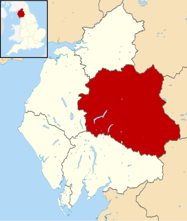
Eden is a local government district in Cumbria, England. Its council is based in Penrith. It is named after the River Eden which flows north through the district toward Carlisle. The district had a population of 49,777 according to the 2001 census, increasing to 52,564 at the 2011 Census. A 2019 estimate put it at 53,253.

Penrith is a market town and civil parish in the county of Cumbria, England, less than 3 miles (5 km) outside the Lake District National Park. It had a population of 15,181 at the 2011 Census. Historically in Cumberland, Penrith's local authority is currently Eden District Council, which is based in the town, as were the defunct Penrith Urban and Rural District councils. From 1974 to 2015, it was an unparished area with no local council, but a civil parish was reintroduced as Penrith Town Council and first elected on 7 May 2015.
The Cockermouth, Keswick and Penrith Railway (CK&PR) was an English railway company incorporated by Act of Parliament on 1 August 1861, to build a line connecting the town of Cockermouth with the London and North Western Railway (LNWR) West Coast Main Line at Penrith. Arrangements for the use of the stations at either end were included. Passenger and goods traffic was worked by the LNWR and mineral traffic by the North Eastern Railway, both of whom had shares in the company. The line was 31+1⁄2 miles (50.7 km) in length, and had eight intermediate stations.

Shap is a linear village and civil parish located among fells and isolated dales in Eden district, Cumbria, England, in the historic county of Westmorland. The parish had a population of 1,221 in 2001, increasing slightly to 1,264 at the 2011 Census.
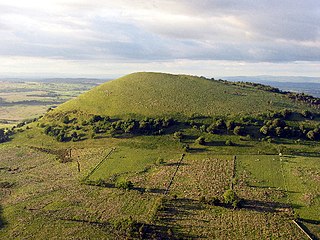
Great Mell Fell is an isolated hill or fell in the English Lake District, north of Ullswater and adjacent to the Eastern Fells. It rises from a level plain to a height of 537 m. Its top is an excellent viewpoint for many of the surrounding higher fells. The fell is now owned and managed by the National Trust and offers a place of quiet refuge.

The Trout Beck is a fast flowing stream of the Lake District in North West England. It is one of the main sources of replenishment for Windermere, and is part of the Leven catchment. Its name comes from Old Norse and appears in documents from 1292 as Trutebyk. The river rises between the peaks of Stony Cove Pike and Thornthwaite Crag in the High Street range, at a height of about 1,970 feet.

Lakes is a large civil parish in the South Lakeland district of Cumbria, England. In the 2001 census the parish had a population of 5,127, decreasing at the 2011 census to 4,420. It covers the small town of Ambleside, and the villages and hamlets of Clappersgate, Rydal, Grasmere, Troutbeck, Chapel Stile, Elterwater, Little Langdale and Waterhead.

Hesket, also known as Hesket-in-the-Forest, is a large civil parish in the Eden District of Cumbria, England, along the main A6 between Carlisle and Penrith. At the 2001 census it had a population of 2,363, increasing to 2,588 at the 2011 census, and estimated at 2,774 in 2019. The parish formed in 1894 with the passing of the Local Government Act 1894 and grew to incorporate the former parish of Plumpton Wall by a County Review Order in 1934. The Parish is part of the historic royal hunting ground of Inglewood Forest, and settlement in the area dates back to the Roman occupation.
Dacre is a small village, civil parish and electoral ward in the Lake District National Park in the Eden District of Cumbria, England, and historically in Cumberland. In the 2001 census, the parish, which includes Newbiggin and Stainton, had a population of 1,326, increasing to 1,438 at the 2011 Census.

Hutton is a small civil parish about 6 miles (9.7 km) west of Penrith in the English county of Cumbria. The parish contains the small mansion and former pele tower of Hutton John, the seat of the Hudleston family.

Yoke is a fell in the Lake District in Cumbria, England. It has a height of 706 m (2,316 ft) and is situated in the far eastern sector of the national park, 6½ kilometres ENE of the town of Ambleside. Yoke is the southern extremity of the long ridge that runs southwards from the fell of High Street. Yoke’s name is believed to be derived from the Old English language word geoc which is similar to the German word joch meaning mountain ridge.

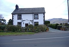
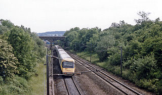
Troutbeck railway station was situated on the Cockermouth, Keswick and Penrith Railway between Penrith and Cockermouth in Cumberland, England. The station served the hamlet of Troutbeck. It opened to passenger traffic on 2 January 1865, and closed on 6 March 1972.

Carleton is a suburb of the town of Penrith, Cumbria, England, that has seen a huge growth in housing since the 1960s and is, of 2018, still expanding due to the Carleton Meadows, Carleton Manor and Woodberry Heights developments. It was formerly a separate small village or hamlet one mile east of the centre of Penrith.
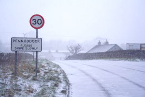
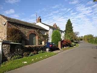
Penruddock is a small village in Cumbria, England, 5.5 miles to the west of Penrith. It forms part of the civil parish of Hutton.
Clifton & Lowther railway station was a station on the Lancaster and Carlisle Railway (L&CR) south of Penrith near to the village of Clifton. Although it was the original terminus to cross Pennines rail traffic on the Eden Valley Railway, it was rapidly by-passed by a new line and junction. The station, which was on the West Coast Main Line, was treated as a private stop by the Earls of Lonsdale.

Braithwaite is a village in the northern Lake District, in Cumbria, England. Historically in Cumberland, it lies just to the west of Keswick and to the east of the Grisedale Pike ridge, in the Borough of Allerdale. It forms part of the civil parish of Above Derwent.

Troutbeck Bridge is a village in South Lakeland, Cumbria, England. It is situated 1 mile north of Windermere on the A591 road running through the Lake District and was historically in the county of Westmorland. The main secondary school for Windermere and Ambleside, The Lakes School, is located in the village, as is the postal sorting office for the area. Troutbeck Bridge takes its name from where the road crosses the Trout Beck.

Hutton Moor End is a hamlet on the Hutton Moor Road in the north east of the Lake District in Cumbria, England. It lies within the civil parish of Mungrisdale and is known locally as 'Moor End' as it is at the end of the Hutton Moor on an old route-way between Penrith to Keswick.

Trout Beck is a 7.6 miles (12.3 km) long stream or beck in the English Lake District, Cumbria. It rises on the northwestern slopes of Great Dodd, with tributaries including Groove Beck and Thornsgill Beck, and flows east then north to the hamlet of Troutbeck. It then flows west, parallel to and south of the A66 road, going just south of Hutton Moor End then under the old Hutton Moor Road at Wolt Bridge where it joins the River Glenderamackin.