
Cape Cod is a hook-shaped peninsula extending into the Atlantic Ocean from the southeastern corner of Massachusetts, in the northeastern United States. Its historic, maritime character and ample beaches attract heavy tourism during the summer months. The name Cape Cod, coined in 1602 by Bartholomew Gosnold, is the ninth oldest English place-name in the U.S.
The Cape Cod National Seashore (CCNS) encompasses 43,607 acres on Cape Cod, in Massachusetts. CCNS was created on August 7, 1961, by President John F. Kennedy, when he signed a bill enacting the legislation he first co-sponsored as a Senator a few years prior. It includes ponds, woods and beachfront of the Atlantic coastal pine barrens ecoregion. The CCNS includes nearly 40 miles (64 km) of seashore along the Atlantic-facing eastern shore of Cape Cod, in the towns of Provincetown, Truro, Wellfleet, Eastham, Orleans and Chatham. It is administered by the National Park Service.
Eastham is a town in Barnstable County, Massachusetts, United States, Barnstable County being coextensive with Cape Cod. The population was 5,752 at the 2020 census.

Truro is a town in Barnstable County, Massachusetts, United States, comprising two villages: Truro and North Truro. Located slightly more than 100 miles (160 km) by road from Boston, it is a summer vacation community just south of the northern tip of Cape Cod, in an area known as the "Outer Cape". English colonists named it after Truro in Cornwall, United Kingdom.
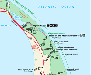
North Truro is a village in the town of Truro, Massachusetts, United States. Due to its proximity to urbanized Provincetown, it is somewhat more densely developed than the rest of the town, with houses and small resort facilities lining the two main thoroughfares, U.S. Route 6 and MA Route 6A. It is home to Truro Vineyards, one of two operating wineries on Cape Cod. North Truro is located at 42°03′35″N70°08′31″W.

Massachusetts Route 6A is the state road for two sections formerly known as U.S. Route 6 (US 6) on Cape Cod. Most of Route 6A is also known as the Old King's Highway. Combining the 2 major sections, the highway is approximately 62 miles (100 km) long.

This is a list of the National Register of Historic Places listings in Barnstable County, Massachusetts.

Nauset Light, officially Nauset Beach Light, is a restored lighthouse on the Cape Cod National Seashore near Eastham, Massachusetts, erected in 1923 using the 1877 tower that was moved here from the Chatham Light. It is listed on the National Register of Historic Places. The tower is a cast-iron plate shell lined with brick and stands 48 feet (15 m) high. The adjacent oil house is made of brick and has also been restored. Fully automated, the beacon is a private aid to navigation. Tours of the tower and oil house are available in summer from the Nauset Light Preservation Society which operates, maintains and interprets the site. The tower is located adjacent to Nauset Light Beach.

Race Point Light is a historic lighthouse on Cape Cod, in Provincetown, Massachusetts; it is on the National Register of Historic Places. The original tower, first illuminated in 1816, was replaced in 1876 with the current 45-foot tall iron-plated tower and a new keeper's dwelling. The American Lighthouse Foundation operates the property and rents out two buildings for overnight stays. The actual light is maintained by the Coast Guard. The site is reached by walking about 45 minutes over sand; with a National Park Service Oversand Permit, a four-wheel-drive vehicle can be used.

The Highland Light is an active lighthouse on the Cape Cod National Seashore in North Truro, Massachusetts. The current tower was erected in 1857, replacing two earlier towers that had been built in 1797 and 1831. It is the oldest and tallest lighthouse on Cape Cod.

The Nauset Archaeological District is a National Historic Landmark District in Eastham, Massachusetts. Located within the southern portion of the Cape Cod National Seashore, this area was the location of substantial ancient settlements since at least 4,000 BC.

The Atwood–Higgins Historic District encompasses a historic property with deep colonial roots in Cape Cod National Seashore. Located on Bound Brook Island on the west side of Wellfleet, Massachusetts, the centerpiece of the district is the Thomas Atwood House, built c. 1730. The property is emblematic of Cape Cod's colonial origins and its later transformation into a summer resort area. The house was listed on the National Register of Historic Places in 1976; the district was listed in 2010. The property is open for guided tours by the National Park Service on a seasonal basis.

The Fort Hill Rural Historic District is a historic district encompassing two farmsteads with more than 200 years of history in Eastham, Massachusetts. The district is a 100-acre (40 ha) area of forest, fields, and salt marshes that was owned by the Knowles and Penninman families from 1742 to 1941. It has been part of the Cape Cod National Seashore since 1961. The area is dominated by the rise called "Fort Hill", which provides extensive views of the area and has its own rich history. The district includes the Edward Penniman House and Barn, previously listed on the National Register of Historic Places, and the Nauset Archeological District, a National Historic Landmark.

The Highland House is a historic hotel building, now serving as a museum, located at 27 Highland Light Road within the Cape Cod National Seashore in Truro, Massachusetts. It is located in the Cape Cod National Seashore near the Highland Light in the Truro Highlands Historic District. The present two story wood-frame building was constructed in 1907 by Isaac Small, whose family had been serving tourists in the area since 1835.
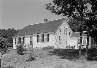
The Jedediah Higgins House is a historic house on Higgins Hollow Road in North Truro, Massachusetts. It is one of the least altered 19th-century Cape style houses in the Cape Cod National Seashore, and an excellent early example of that style. It is a 1+1⁄2-story post-and-beam house, whose front facade typifies the Cape style: a central doorway flanked by windows on either side. Its interior floor plan is also typical, with two rooms on the south side and one large one to the north, with a central chimney. Interior finishes have also been preserved, including wood flooring, paneling, and wainscoting.
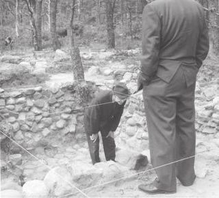
The Samuel Smith Tavern Site is a historic archeological site in Wellfleet, Massachusetts. It encompasses the remains of a late 17th-century tavern operated by Samuel Smith, owner of Great Island, which shelters Wellfleet Harbor. The tavern site is located within the Cape Cod National Seashore, and is accessible via the Great Island Trail. The site was excavated in 1969–70, recovering thousands of artifacts, including clay pipes, drinking artifacts, a harpoon, and a chopping block fashioned from whale vertebrae.

The Three Sisters of Nauset are a trio of historic lighthouses off Cable Road in Eastham, Massachusetts. The original three brick towers fell into the sea due to erosion in 1890 and were replaced with wooden towers on brick foundations in 1892. The Sisters were decommissioned in 1911 but one of them, the Beacon, was moved back from the shoreline and attached to the keeper's house. It continued to operate but was replaced by a new steel tower, the Nauset Light, in 1923.
This is a list of the National Register of Historic Places listings in Cape Cod National Seashore.

The Dune Shacks of Peaked Hill Bars Historic District includes dune shacks that were home to American artists and writers from the 1920s to present day. The historic district, located in the Outer Cape towns of Provincetown and Truro, comprises 1,950 acres of the Cape Cod National Seashore. It was listed on the National Register of Historic Places in 2012. The name is derived from a Life-Saving Station known as Peaked Hill Bars that was established in 1882 on the lower cape.

The Pine Grove Cemetery is the second oldest cemetery in Truro, Massachusetts. The cemetery was established in 1799; it is located on Cemetery Road in a remote area of the Cape Cod National Seashore. Originally established by Truro's Methodists, the cemetery was located near a church which has not survived. The cemetery is surrounded by a fence made of granite posts connected by iron rails. Access to its interior is via a gravel roadway that roughly bisects the property from east to west; there is also a grassy path to a pedestrian gate on the south side. Burials in the cemetery date from 1799 to the recent past.


