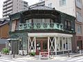
Ginza is a district of Chūō, Tokyo, located south of Yaesu and Kyōbashi, west of Tsukiji, east of Yūrakuchō and Uchisaiwaichō, and north of Shinbashi. It is a popular upscale shopping area of Tokyo, with numerous internationally renowned department stores, boutiques, restaurants and coffeehouses located in its vicinity. It is considered to be one of the most expensive, elegant, and luxurious city districts in the world.

Sumida is a special ward located in Tokyo Metropolis, Japan. The English translation of its Japanese self-designation is Sumida City.

Kōtō is a special ward located in Tokyo Metropolis, Japan. The ward refers to itself as Kōtō City in English. As of May 1, 2015, the ward has an estimated population of 488,632, and a population density of 12,170 persons per km². The total area is approximately 40.16 km².

Kyōbashi (京橋) is a neighborhood east of Tokyo Station in Chūō, Tokyo, Japan. It is one of the city's oldest commercial districts, although it has since been eclipsed by Ginza to the south and Nihonbashi to the north. Kyobashi, together with Nihonbashi and Kanda, is the core of Shitamachi, the original downtown center of Edo-Tokyo, before the rise of newer secondary centers such as Shinjuku and Shibuya.

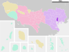
Chūō is a special ward that forms part of the heart of Tokyo, Japan. The ward refers to itself in English as Chūō City. It was formed in 1947 as a merger of Kyobashi and Nihonbashi wards following Tokyo City's transformation into Tokyo Metropolis.
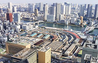
Tsukiji Market is a major tourist attraction for both domestic and overseas visitors in Tokyo. The area contains retail markets, restaurants, and associated restaurant supply stores. Before 2018, it was the largest wholesale fish and seafood market in the world. The market opened on 11 February 1935 as a replacement for an older market that was destroyed in the 1923 Great Kantō earthquake. It was closed on 6 October 2018, with wholesale operations moving to the new Toyosu Market.

Nihonbashi (日本橋) is a business district of Chūō, Tokyo, Japan which grew up around the bridge of the same name which has linked two sides of the Nihonbashi River at this site since the 17th century. The first wooden bridge was completed in 1603. The current bridge, designed by Tsumaki Yorinaka and constructed of stone on a steel frame, dates from 1911. The district covers a large area to the north and east of the bridge, reaching Akihabara to the north and the Sumida River to the east. Ōtemachi is to the west and Yaesu and Kyobashi to the south.

Yaesu (八重洲) is a district in Chūō, Tokyo, Japan, located north of Ginza, west of Nihonbashi and Kyōbashi, and adjacent to the east side of Tokyo Station. The Yaesu exit of this station, which faces Nihonbashi, is recent and primarily provides access to the Shinkansen platforms.

Tsukishima (月島) is a place located in Chūō, Tokyo, Japan, in the Sumida River estuary. It is a reclaimed land next to Tsukuda District. The land reclamation completed in 1892, using earth from the dredging work performed to create a shipping channel in Tokyo Bay. At this time, it was designated as industrial area in accordance with the Fukoku Kyōhei National Policy.

Chūō Ward is one of the six wards of the city of Chiba in Chiba Prefecture, Japan, and is the seat of the city government, and the location of the prefectural government offices for Chiba Prefecture. It is also the commercial center of Chiba. As of April 2012, the ward had an estimated population of 200,157 and a population density of 4,470 persons per km². The total area was 44.81 km², making it the most populous of the six wards of Chiba city.

Chūō-ku is one of ten wards of the city of Saitama, in Saitama Prefecture, Japan, and is located in the northern part of the city. As of 1 March 2021, the ward had an estimated population of 102,364 and a population density of 12,000 persons per km2. Its total area is 8.39 square kilometres (3.24 sq mi). Despite its name, it is not the administrative or the commercial centre of the city, roles which are designated to Urawa-ku and Ōmiya-ku respectively.

Toyosu (豊洲) is an area of Kōtō, Tokyo, Japan. Its subdivisions consist of Toyosu 1, 2, 3, 4, 5, and 6 chome.

Rikkyo Ikebukuro Junior and Senior High School (立教池袋中学校・高等学校) is private boys' junior and senior high school in Ikebukuro, Toshima, Tokyo.
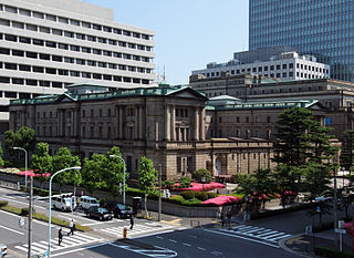
Hongokuchō or more formally Nihonbashi Hongokuchō is a neighborhood of Nihonbashi, Chuo-ku, Tokyo. It is the location of the Bank of Japan.

Chūō (中央) is a district of Nakano, Tokyo, Japan.

Harumi (晴海) is a district of Chūō, Tokyo. The district contains five chōme (subdivisions), and the postal code is 104-0053. Harumi is located on reclaimed land, created by dropping earth and sediment generated from expanding Tokyo Bay. The construction took place starting in the middle of the Meiji era and was completed early in the Showa era. Before an official name was decided for the district, it was called Tsukishima No. 4.

Tsukudajima is a small island in Tokyo Bay, facing Tsukiji to its west. Originally, Tsukudajima was a tiny island at the mouth of the Edogawa river in Tokyo Bay. It was inhabited by a fishing community who migrated from Osaka in early 1600s. It is home to the famous dish Tsukudani (佃煮). Next to it was built on reclaimed land the high-rise district of Tsukishima.

Chuo Municipal Taimei Elementary School is a public elementary school in Ginza, Chuo, Tokyo. It is operated by the Chuo City Board of Education (中央区教育委員会).
Chuo Municipal Chuo Elementary School is a public elementary school in Minato, Chuo, Tokyo. It is operated by the Chuo City Board of Education (中央区教育委員会).
Nihonbashi Bakurochō (日本橋馬喰町), known in short as Bakurochō (馬喰町), is a neighborhood in Chuo-ku, Tokyo.