Tropical storm (39–73 mph, 63–118 km/h)
Category 1 (74–95 mph, 119–153 km/h)
Category 2 (96–110 mph, 154–177 km/h)
Category 3 (111–129 mph, 178–208 km/h)
Category 4 (130–156 mph, 209–251 km/h)
Category 5 (≥157 mph, ≥252 km/h)
Unknown
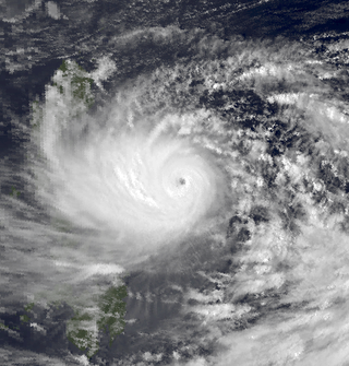
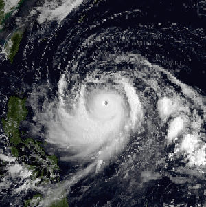
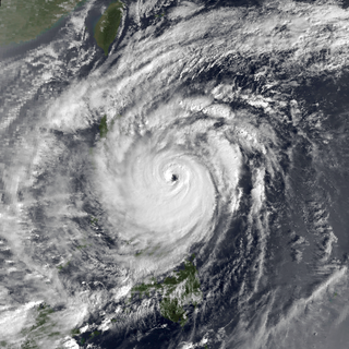
On December 8, 1998, the Joint Typhoon Warning Center (JTWC) issued a Tropical Cyclone Formation Alert for a tropical disturbance located within the vicinity of the western Caroline Islands. [1] At 06:00 UTC, the JTWC upgraded the system, which was located 565 km (350 mi) east-southeast of Palau, into a tropical depression, [2] with the JMA following suit six hours later. [3] [nb 1] Initially, the depression moved fairly quickly on a northwesterly course in response to a weak trough to its north, [1] while also slowly strengthening and passing about 185 km (115 mi) north of Palau. [2] At 00:00 UTC on December 9, the Philippine Atmospheric, Geophysical and Astronomical Services Administration (PAGASA) began to track the storm and assigned it with the local name Norming. [5] At noon, PAGASA [6] and the JMA upgraded the depression to a tropical storm, [3] and six hours later, the JTWC followed suit. [7] After crossing the 10th parallel north, Faith turned towards the west-northwest, and by December 10, the storm entered a period of rapid intensification. [2] The JMA upgraded Faith into a severe tropical storm early on December 10, [3] and twelve hours later, the JTWC classified Faith, just offshore Samar Island, as a typhoon. [2]
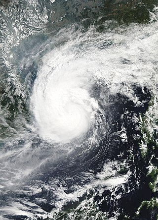
The typhoon then tracked across the islands of Samar and Masbate, and next clipped the northern tip of Palawan Island [2] before entering the South China Sea. [8] At 18:00 UTC, the JMA upgraded Faith into a typhoon, while also estimating that it attained its peak intensity of 120 km/h (75 mph) and a minimum barometric pressure of 970 mbar (28.6 inHg). [9] After clearing the Philippines, Typhoon Faith tracked westward [2] and briefly moved west-southwest. On the evening of December 11, the JTWC increased the intensity to 170 km/h (105 mph), its peak wind speed. While maintaining peak intensity, [1] Typhoon Faith slowly decelerated while tracking on a west-northwesterly course as it approached the Vietnamese coast due to the effects of another mid-latitude trough, which eroded the subtropical ridge to its north. As a result of this pattern change, Faith began to encounter increased wind shear, which triggered a weakening trend, [2] and at 00:00 UTC on December 12, the JMA downgraded Faith into a severe tropical storm. [9] [nb 2] At 00:00 UTC on December 14, Faith made landfall in Vietnam just north of Nha Trang. [2] At the time of landfall, the JTWC estimated winds of 115 km/h (70 mph) [7] while the JMA determined that Faith had weakened to a tropical depression. [3] Once inland, the storm began to quickly dissipate; [2] the JMA ceased tracking the system at noon the same day. [3]
Preparations and impact
Philippines
In advance of the typhoon, authorities issued a No. 3 storm signal, [11] even though only a No. 1 storm signal was issued for Manila. [11] On December 13, all classes in Manila were suspended. [12] Sixteen Philippine Airlines flights to and from the central Philippines were cancelled. [13] In the capital city of Manila, heavy rains caused street flooding. [14] Several villages on Samar island were flooded. [13] Around 400 people combined in the Catanduanes and Aklan provinces were evacuated to shelter due to rising floodwaters. A grocery store in Ibajay collapsed due to high winds. Toppled posts and downed trees clogged highways in the province of Sorsogon. [15] Two bodies were recovered off Dumaguete. [16] Offshore, the Philippine Navy rescued 100 people from a ferry traveling from the Philippines to Malaysia. [1] A 12 m (40 ft) boat sunk offshore Zamboanga City; all 10 of its crew were rescued to safety. [13] Off of Pilas Island, four people were rescued and eleven were missing when the boat Myra-1 sank in heavy seas. [14] Seventeen passengers were rescued, fourteen people were rendered missing, and two bodies were recovered when high waves toppled the motor vessel Lion No. 3. [17]
Overall, 33 people were killed, with 30 others wounded and 36 others listed missing. [18] A total of 6,423 homes were damaged and 3,234 houses were destroyed, [19] leaving more than 20,000 homeless. [1] Damage was estimated at $25.9 million, [nb 3] with $6.82 million from crops, $15.9 million from public infrastructure, and $3.37 million from private infrastructure. [19] The storm affected 17 provinces, and 135 evacuation centers were opened. [20] Following the storm, Philippines President Joseph Estrada pledged emergency funding for four provinces struck by the typhoon, along with a series of wintertime rainstorms. [21]
Vietnam
Faith was the second tropical cyclone to affect Vietnam that month, following Tropical Storm Dawn. Twenty-one people were killed in Khanh Hoa Province and Binh Dinh Province, including five in Da Nang. [15] Nationwide, at least 38 people were killed in Vietnam with over 10,000 evacuated due to flooding in low-lying areas. Damage in Vietnam exceeded $20 million. [1] A total of 602 homes were destroyed, another 16,327 were damaged, and 58,487 ha (144,520 acres) of rice fields were inundated. [22]
See also
Notes
- ↑ The Japan Meteorological Agency is the official Regional Specialized Meteorological Center for the western Pacific Ocean. [4]
- ↑ Wind estimates from the JMA and most other basins throughout the world are sustained over 10 minutes, while estimates from the United States-based Joint Typhoon Warning Center are sustained over 1 minute. 10-minute winds are about 1.14 times the amount of 1-minute winds. [10]
- ↑ All currencies are converted to United States Dollars using Philippines Measuring worth with an exchange rate of the year 1998.
Related Research Articles

The 2003 Pacific typhoon season was a slightly below average yearlong period of tropical cyclogenesis exhibiting the development of 45 tropical depressions, of which 21 became named storms; of those, 14 became typhoons. Though every month with the exception of February and March featured tropical activity, most storms developed from May through October. During the season, tropical cyclones affected the Philippines, Japan, China, the Korean Peninsula, Indochina, and various islands in the western Pacific.

Typhoon Mike, known in the Philippines as Super Typhoon Ruping, of 1990 was the strongest typhoon to hit the Philippines since Typhoon Irma in 1981 and Typhoon Nina in 1987. Forming from an area of persistent convection over the Caroline Islands, Mike was first designated on November 6, 1990 and moved generally westward. Later that day, the depression strengthened to Tropical Storm Mike near Yap. Mike became a typhoon early on November 9, and subsequently entered a period of rapid deepening. Late on November 10, the typhoon reached its maximum intensity of 115 mph (185 km/h), as estimated by the Japanese Meteorological Agency. After weakening slightly, Mike made landfall in the central Philippines. The storm weakened considerably due to land interaction, only to briefly re-intensify on November 14. Typhoon Mike turned west-northwest and later north-northwest, avoiding land interaction with Vietnam. Vertical wind shear increased, and on November 15, Mike weakened below typhoon intensity. Early the next day, the storm passed over western Hainan Island, and degraded to a tropical depression that night. After briefly emerging into the Gulf of Tonkin, Mike passed over Northern Vietnam and southern China, where it dissipated on November 18.

Typhoon Babs, known in the Philippines as Typhoon Loleng, was a powerful typhoon that struck the Philippines days after Typhoon Zeb hit the same area. The seventh typhoon of the inactive 1998 Pacific typhoon season, Babs formed on October 14 between the Philippines and Guam. The storm moved westward initially, failing to intensify initially due to the outflow from Typhoon Zeb to the northwest. Babs slowed and briefly turned to the south before advancing to the northwest, whereupon it rapidly intensified into a strong typhoon. On October 20, the official Japan Meteorological Agency (JMA) estimated peak 10‑minute winds of 155 km/h (96 mph), while the unofficial Joint Typhoon Warning Center (JTWC) estimated peak 1‑minute winds of 250 km/h (160 mph), making Babs an unofficial super typhoon. The storm struck the Philippine island of Catanduanes at that intensity and weakened slightly before hitting Luzon. Babs turned northward once in the South China Sea, later weakening due to unfavorable conditions and transitioning into an extratropical cyclone on October 27 in the Taiwan Strait.
Typhoon Dot, known in the Philippines as Typhoon Saling, was the strongest storm of the 1985 season. Dot originated from a small area of thunderstorm activity in early to mid October. The system was first classified on October 11, and steadily intensified over the next few days. Dot attained typhoon strength on October 15, and subsequently entered a period of explosive deepening, which was not anticipated by forecasters. The next day the intensification rate slowed, but that evening, Dot attained its maximum intensify. A steady weakening trend began on October 17, though the system maintained typhoon intensity through the passage of the Philippines. After entering the South China Sea late on October 18, Dot briefly re-intensified, only to weaken as it approached Vietnam. On October 21, Dot struck Vietnam while still a typhoon, but dissipated the next day over the high terrain of the nation.

Typhoon Utor, known in the Philippines as Typhoon Seniang, swept through the central Philippines in December 2006, exacerbating the damage left behind by previous Philippine typhoon strikes that year. Residual moisture from the tropical cyclone indirectly contributed to extensive flooding in Malaysia. Utor originated from an area of disturbed weather that organized into a tropical depression on December 7 west-southwest of Yap. The cyclone steadily progressed westward while gradually intensifying, reaching tropical storm intensity late on December 7. On December 9 and the ensuing two days, Utor crossed the central Philippines and reached typhoon strength before weakening somewhat upon entry into the South China Sea. Reintensification ensued afterwards, and Utor reached its peak intensity on December 13 with maximum sustained winds of 155 km/h (100 mph) shortly after regaining typhoon strength. However, wind shear and dry air began to take its toll on Utor thereafter, quickly weakening the storm until its dissipation on December 15.

Typhoon Alex, known in the Philippines as Typhoon Etang, affected the Taiwan, China, and South Korea during July 1987. Typhoon Alex developed from the monsoon trough that spawned a tropical disturbance late on July 21 southwest of Guam which organized into a tropical depression shortly thereafter. The system steadily became better organized, and the next day, a tropical depression had developed. Satellite intensity estimates gradually increased, and on July 23, the depression intensified into Tropical Storm Alex. After initially tracking west-northwest, Tropical Storm Alex started tracking northwest. An eye developed on July 24, and on the next day, Alex was classified as a typhoon, when Alex attained its peak intensity of 120 km/h (75 mph) and a minimum barometric pressure of 970 mbar (29 inHg). Alex weakened while tracking more northward, though interaction with Taiwan resulted in a more westward track starting on July 27. The storm struck near Shanghai as a tropical storm, and weakened over land, although it remained identifiable through August 2.

Typhoon Clara, known in the Philippines as Typhoon Rubing, left flooding in the northern Philippines and southern China during September 1981. An area of disturbed weather was first detected on September 11 near Ponape. After moving westward, the system gradually became better organized and thunderstorm activity increased. On September 16, the system attained tropical storm status. Two days later, Clara attained typhoon intensity and subsequently began to deepen at a faster rate. On September 19, Clara reached maximum intensity, before making landfall along the northern tip of Luzon. Clara steadily weakened after interacting with land, but by late on September 20, Clara leveled off in intensity over the South China Sea. The next day, Clara moved ashore to the east-northeast of Hong Kong while still at typhoon intensity before rapidly dissipating over land.
Typhoon Nepartak, known in the Philippines as Typhoon Weng, was a modest tropical cyclone that struck the central Philippines and the southern China island of Hainan in November 2003. Forming as a tropical depression on November 11 between Yap and Guam, the system moved westward and slowly intensified. It received the name Nepartak midday on November 12 from the Japan Meteorological Agency, becoming the 20th named storm of the 2003 Pacific typhoon season. On November 13, Napartak struck Samar in the Philippines and bisected the island chain. Up to four million people lost power, and transportation ground to a halt; over 5,000 individuals became stranded on ships forced to stay in port during the tropical storm. It was reported that 13 individuals died in the storm in the Philippines.

Severe Tropical Storm Tess known in the Philippines as Tropical Storm Welpring was the second of three tropical cyclones to directly impact the Philippines in a two-week time frame in 1988. An area of disturbed weather near the Philippines was first observed on November 1. Following an increase in organization, the disturbance was designated as a tropical cyclone on November 4. Moving west, Tess steadily strengthened due to favorable conditions aloft. During the evening of November 5, Tess was estimated to have achieved its highest intensity, with winds of 115 km/h (70 mph). Rapid weakening then ensured as Tess neared Vietnam, and after making landfall in the country on November 6, Tess dissipated the next day.

Typhoon Kim, known in the Philippines as Typhoon Osang, was the second typhoon in a week to directly affect the Philippines during July 1980. Like Typhoon Joe, Kim formed from the near equatorial monsoon trough in the northwestern Pacific Ocean on July 19. The disturbance tracked quickly westward-northwest underneath a subtropical ridge, reaching tropical storm strength on the July 21 and typhoon strength on July 23. After developing an eye, Kim began to rapidly intensify, and during the afternoon of July 24, peaked in intensity as a super typhoon. Several hours later, Kim made landfall over the Philippines, but the storm had weakened considerably by this time. Throughout the Philippines, 40 people were killed, 2 via drownings, and 19,000 others were directly affected. A total of 12,000 homes were destroyed and 5,000 villages were flooded. Less than a week earlier, the same areas were affected by Joe; however, Kim was considered the more damaging of the two typhoons. Land interaction took its toll on Kim, and upon entering the South China Sea, the storm was down below typhoon intensity. Kim continued northwestward but its disrupted circulation prevented re-intensification, and it remained a tropical storm until hitting southern China July 27 to the northeast of Hong Kong, where only slight damage was reported. Later that day, Kim dissipated.

Typhoon Gerald, known in the Philippines as Typhoon Neneng, affected the Philippines, Taiwan, and China during September 1987. A tropical depression developed on September 4, and within 24 hours, intensified into a tropical storm. After initially moving erratically within the Philippine Sea, Gerald moved west-northwest and then northwest while steadily deepening. Gerald obtained typhoon intensity on September 8, and the following day, attained maximum intensity. Shortly thereafter, the typhoon skirted southwestern Taiwan, which resulted in a steady weakening trend. On September 10, Gerald moved ashore north of Hong Kong near Amoy. Gerald dissipated the next day.
Typhoon Dinah, known as Typhoon Luding in the Philippines, was the costliest tropical cyclone to form in the 1987 Pacific typhoon season. It also was the fourth typhoon to form during August 1987. An area of low pressure developed near Guam on August 19, and two days later, the low reached tropical storm intensity as it moved generally west. Intensification was initially gradual, with Dinah becoming a typhoon early on August 24, before it subsequently intensified at a faster pace. Dinah reached its highest strength on August 26 before turning northward on August 28 and into a less favorable conditions aloft, which prompted weakening. Dinah entered the Sea of Japan after passing near Okinawa on August 29, where Dinah leveled off in intensity. The system then began to recurve towards southwestern Japan, and after tracking through the area, Dinah transitioned into an extratropical cyclone on August 31, although the remnants could be traced for four more days as it approached the International Date Line.

Typhoon Kelly, known as Typhoon Oniang in the Philippines, struck Japan during the middle of October 1987. An area of disturbed weather formed along the monsoon trough near Yap on October 6. Although thunderstorm activity was initially displaced from the center, gradual development occurred nevertheless. The disturbance became a tropical depression on October 9, and a tropical storm the next day. While moving generally north-northwest towards Japan, Kelly attained typhoon intensity on October 12. Continuing to intensify, Typhoon Kelly reached its maximum intensity on October 15, but a weakening trend began thereafter. The next day, the typhoon passed over the islands of Shikoku and Honshu. By October 17, Kelly completed its transition into an extratropical cyclone.

Typhoon Cary, known as Typhoon Ising in the Philippines, was the second of two tropical cyclones to affect Vietnam in a week. An area of disturbed weather developed southwest of Pohnpei on August 6, 1987. The system initially remained disorganized, but by August 14, Cary had attained tropical storm intensity. After initially moving north-northwest, Cary turned west-northwest, although intensification was slow to occur. On August 15, Cary was upgraded into a typhoon, and on August 17, the typhoon peaked in intensity. Typhoon Cary then made landfall in northern Luzon while at peak intensity. Across the Philippines, 954 houses were damaged and an additional 89 were destroyed, which left 55,567 people, or 13,247 families that were either homeless or otherwise sought shelter. Five people died in the country while damage totaled $5.58 million (1987 USD), including $1.45 million from agriculture and $4.13 million from infrastructure. The storm weakened over land, but re-intensified into a typhoon over the South China Sea. On August 21, Typhoon Cary passed just south of Hainan, where hundreds of homes were damaged but no fatalities occurred, and subsequently entered the Gulf of Tonkin. The storm weakened as it approached Vietnam, and on August 23, the storm dissipated inland over Laos. Across Vietnam, almost 40,000 ha of land were flooded or destroyed. Twenty people were killed and many others were injured.

Typhoon Agnes, known in the Philippines as Typhoon Undang, was the fourth final tropical cyclone to affect the Philippines during the 1984 Pacific typhoon season. An area of disturbed weather developed near the equator and the Caroline Islands on October 28. Following an increase in organization, the cyclone was designated a tropical storm on October 31. After tracking northwest initially, Agnes turned west-northwest the next day, a course that the system would maintain for the rest of its lifetime. Agnes intensified into a typhoon on November 2, and on November 4, attained peak intensity. The storm then made landfall on Samar Island, part of the Philippines, at that intensity. The storm weakened over land, but re-intensified over the South China Sea; Agnes obtained a secondary peak intensity on November 6. The next day, Typhoon Agnes moved ashore Vietnam while still at typhoon intensity. The storm rapidly deteriorated over land and dissipated by November 8 over Thailand.

Typhoon Joe, known in the Philippines as Typhoon Nitang, affected the Philippines, China, and Vietnam during July 1980. An area of disturbed weather formed near the Caroline Islands on July 14. Shower activity gradually became better organized, and two days later, the system was upgraded into a tropical depression. On July 18, the depression was classified as Tropical Storm Joe. Initially, Joe moved northwest, but began to turn to the west-northwest, anchored by a subtropical ridge to its north. Joe started to deepen at a faster clip, and attained typhoon intensity on July 19. The eye began to clear out, and the next day, Joe reached its highest intensity. Shortly thereafter, Joe moved ashore the Philippines. There, 31 people were killed and 300,000 others were directly affected. Around 5,000 homes were destroyed, resulting in an additional 29,000 homeless. Damage in the nation was estimated at $14.5 million (1980 USD).
Typhoon Betty, known in the Philippines as Typhoon Aring, was the strongest typhoon to strike the Philippines in ten years. An area of disturbed weather developed on October 27, 1980, near Truk Atoll. After turning east from south, the disturbance was classified as a tropical storm on October 29 as it passed near Guam, causing only minor damage. Following a turn to the west-northwest, Betty attained typhoon intensity the next day. On November 4, Betty peaked in intensity. Later that day, Betty moved ashore over Luzon, introducing a rapid weakening trend. Over land, Betty then began to turn north due to a weakening subtropical ridge to its north and a trough offshore Taiwan. By November 8, Betty, after moving offshore, had completed its transition into an extratropical cyclone, and dissipated that same day.

Typhoon Irving, known in the Philippines as Tropical Storm Ruping, was a mid-season tropical cyclone that affected the Philippines and China during September 1982. An area of disturbed weather developed within the monsoon trough during early September 1982 near Guam. Following an increase in organization, a tropical depression developed on the morning of September 5. Later that day, the depression intensified into Tropical Storm Irving. Irving tracked westward, nearly becoming a typhoon before hitting the central Philippines. There, Irving uprooted trees, downed power and telephone lines, triggered landslides, and forced the cancellation of several domestic airline flights. Irving damaged 7,890 houses in Albay and Sorsogon provinces alone, resulting in 138,500 people homeless. Nation-wide, 65 people were killed, 26 others were hurt, and 29 were rendered missing. A total of 44,383 families or 248,040 residents sought shelter. Moreover, 18,488 homes were damaged and 5,599 others were demolished. Damage in the country was assessed at US$23.3 million, including US$14.2 million in crops. While crossing the island chain, Irving turned northwestward. After entering the South China Sea, Irving continued generally northwest, and became a typhoon on September 11. After developing a well-defined eye, Irving attained its peak intensity of 160 km/h (100 mph) the following day. Land interaction with Hainan Island resulted in a weakening trend, and Irving was downgraded to a tropical storm before striking the southern coast of China on September 15. Across the Leizhou Peninsula, 90% of homes were damaged. Onshore, Irving rapidly weakened and the storm dissipated on September 16.
Typhoon Warren, known in the Philippines as Typhoon Huaning, struck the Philippines and China during July 1988. An area of disturbed weather developed within the vicinity of the Caroline Islands during the second week of July. A tropical depression developed southeast of Guam on July 12, and on the next day, intensified into a tropical storm. Tracking generally west-northwest, Warren deepened into a typhoon on July 14. The storm subsequently entered a period of rapid intensification, commencing with Warren reaching its highest intensity on July 16. The following evening, the typhoon brushed Luzon, resulting in a weakening trend, although Warren was still a typhoon when it made landfall near Shantou. Warren rapidly dissipated inland.

Typhoon Eli, known in the Philippines as Typhoon Konsing, struck the Philippines and Hainan during mid-July 1992. A weak low pressure system developed in the Philippine Sea on July 7, which became a tropical depression on the next day. The depression tracked west-northwest and strengthened into a tropical storm on July 10. After turning more westward, Eli steadily intensified, and obtained typhoon intensity that evening. The storm attained its highest intensity of 130 km/h (80 mph) early on July 11 before striking northern Luzon. After entering the South China Sea, the storm maintained most of its intensity as it approached Hainan, although agencies disagree on how precisely strong it was. After passing through Hainan late on July 13, Eli passed through the Gulf of Tonkin on the next day before striking Vietnam, where Eli quickly dissipated.
References
- 1 2 3 4 5 6 Joint Typhoon Warning Center; Naval Pacific Meteorology and Oceanography Center (1999). Annual Tropical Cyclone Report: 1998 (PDF) (Report). United States Navy, United States Air Force. Archived from the original (PDF) on March 4, 2016. Retrieved July 29, 2017.
- 1 2 3 4 5 6 7 8 9 Gary Padgett. "Monthly Global Tropical Cyclone Summary October 1998" . Retrieved July 29, 2017.
- 1 2 3 4 5 Japan Meteorological Agency (October 10, 1992). RSMC Best Track Data – 1990–1999 (Report). Archived from the original (.TXT) on January 22, 2013. Retrieved July 2, 2017.
- ↑ "Annual Report on Activities of the RSMC Tokyo – Typhoon Center 2000" (PDF). Japan Meteorological Agency. February 2001. p. 3. Retrieved July 29, 2017.
- ↑ Old PAGASA Names: List of names for tropical cyclones occurring within the Philippine Area of Responsibility 1991–2000. Philippine Atmospheric, Geophysical and Astronomical Services Administration (Report). Typhoon 2000. Retrieved July 29, 2017.
- ↑ "1998 PAGASA Tropical Cyclone Track Data - Typhoon Norming". June 14, 1999. Retrieved July 29, 2017.
- 1 2 Typhoon 24W Best Track (TXT) (Report). Joint Typhoon Warning Center. December 17, 2002. Retrieved July 29, 2017.
- ↑ Hong Kong Observatory (1999). "Part III – Tropical Cyclone Summaries". Meteorological Results: 1998 (PDF). Meteorological Results (Report). Hong Kong Observatory. p. 27. Retrieved July 29, 2017.
- 1 2 Kenneth R. Knapp; Michael C. Kruk; David H. Levinson; Howard J. Diamond; Charles J. Neumann (2010). 1998 FAITH (1998342N06141). The International Best Track Archive for Climate Stewardship (IBTrACS): Unifying tropical cyclone best track data (Report). Bulletin of the American Meteorological Society. Retrieved July 29, 2017.
- ↑ Christopher W Landsea; Hurricane Research Division (April 26, 2004). "Subject: D4) What does "maximum sustained wind" mean? How does it relate to gusts in tropical cyclones?". Frequently Asked Questions. National Oceanic and Atmospheric Administration's Atlantic Oceanographic and Meteorological Laboratory. Retrieved July 29, 2017.
- 1 2 "Typhoon Faith hits central Philippines". Agence France Presse. December 11, 1998. – via Lexis Nexis (subscription required)
- ↑ "Relief operations rushed to storm ravaged Philippine provinces". Agence France-Presse. December 13, 1998. – via Lexis Nexis (subscription required)
- 1 2 3 "Typhoon Faith hits central Philippines (2)". Agence France Presse. December 11, 1998. – via Lexis Nexis (subscription required)
- 1 2 "At least eight dead, 29 missing in Philippine typhoon Faith: reports". Agence France Presse. December 12, 1998. – via Lexis Nexis (subscription required)
- 1 2 "At least 21 die as typhoon hits Vietnam". Agence France Presse. December 16, 1998. – via Lexis Nexis (subscription required)
- ↑ "Relief rushed to Philippines storm-hit areas, more deaths reported". Agence France Presse. December 13, 1998. – via Lexis Nexis (subscription required)
- ↑ "Two killed, 14 missing as boat sinks in Philippine typhoon". Agence France Presse. December 11, 1998. – via Lexis Nexis (subscription required)
- ↑ Destructive Typhoons 1970-2003 (Report). National Disaster Coordinating Council. November 9, 2004. Archived from the original on November 9, 2004. Retrieved July 29, 2017.
- 1 2 Destructive Typhoons 1970-2003 (Report). National Disaster Coordinating Council. November 9, 2004. Archived from the original on September 1, 2012. Retrieved July 29, 2017.
- ↑ Philippines - Typhoon Faith OCHA Situation Report No. 1. United Nations Department of Humanitarian Affairs (Report). ReliefWeb. December 17, 1998. Retrieved July 29, 2017.
- ↑ Australian Broadcasting Corporation (February 13, 1999). Emergency relief for Philippines flood victims. United Nations Department of Humanitarian Affairs (Report). ReliefWeb. Retrieved July 29, 2017.
- ↑ Office for the Coordination of Humanitarian Affairs (December 18, 1998). Vietnam —Storms and Floods OCHA Situation Report No.3. Disaster Information Center (Report). ReliefWeb. Archived from the original on March 17, 2005. Retrieved March 26, 2009.
External links
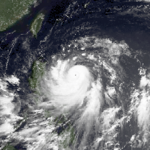
 Typhoon Faith at peak intensity |
Tropical cyclones of the 1998 Pacific typhoon season | ||
|---|---|---|
 | ||