Meteorological history | |
---|---|
Formed | August 30,2020 |
Extratropical | September 7,2020 |
Dissipated | September 10,2020 |
Violent typhoon | |
10-minute sustained (JMA) | |
Highest winds | 195 km/h (120 mph) |
Lowest pressure | 910 hPa (mbar);26.87 inHg |
Category 4-equivalent super typhoon | |
1-minute sustained (SSHWS/JTWC) | |
Highest winds | 250 km/h (155 mph) |
Lowest pressure | 915 hPa (mbar);27.02 inHg |
Overall effects | |
Fatalities | 4 total,6 missing |
Damage | >$100 million (2022 USD) |
Areas affected | Mariana Islands,Japan,South Korea,North Korea,Northeastern China |
IBTrACS | |
Part of the 2020 Pacific typhoon season |
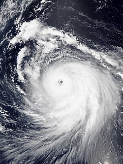
Typhoon Haishen,known in the Philippines as Super Typhoon Kristine,was a powerful tropical cyclone that became the first super typhoon of the 2020 Pacific typhoon season. Being also the tenth named storm and this season's fifth typhoon,Haishen's origins can be tracked back to a disorganised low pressure area situated near Guam. While the disturbance tracked south-westward and quickly organised,the JTWC issued a Tropical Cyclone Formation Alert (TCFA) on the system,and a day later,on September 1,the system became a tropical depression. [1] The depression strengthened into Tropical Storm Haishen according to the Japan Meteorological Agency as it moved southwestward. [2] At about 12:00 UTC on September 2,the Philippine Atmospheric,Geological and Astronomical Services Administration indicated that Haishen had entered the Philippine Area of Responsibility and was subsequently named Kristine. [3] [4] Later that day,Haishen became a typhoon. Intensification on September 3 was significant. Drifting northwestward into extremely favorable conditions,Haishen became a category 3-equivalent typhoon,acquiring a pinhole eye,before undergoing an eyewall replacement cycle (EWRC). Strengthening resumed soon after and the JTWC assessed wind speeds of 135 kn (155 mph;250 km/h) as it peaked as a powerful Category 4 super typhoon and had attained a new,symmetrical,clear eye. [5] [6]
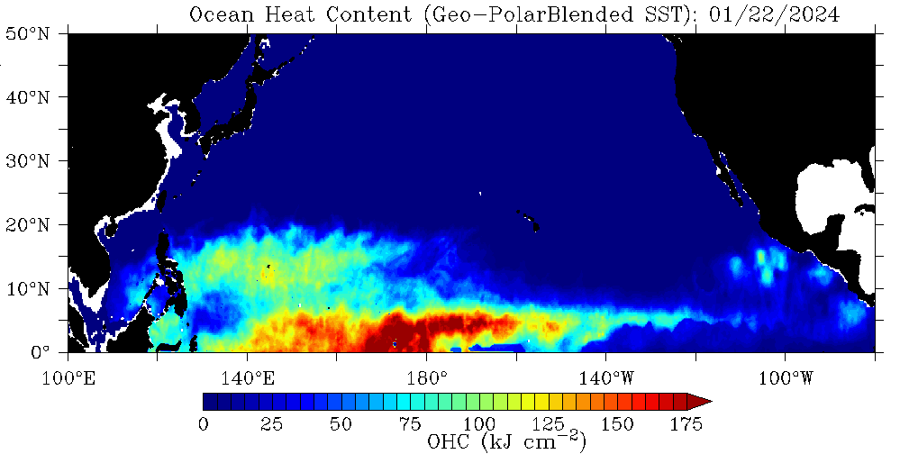
Traversing northward toward land while gaining latitude,ocean heat content became unfavorable for supporting such a strong system,and while the central pressure decreased,the system's wind speeds began decreasing,as the structure began degrading. The eye's former shape was no longer present as it appeared ragged on satellite imagery,and Dvorak analysis indicated that Haishen was beginning to weaken steadily. On September 5,Haishen began to lose its eye as its inner eyewall began contracting,and it subsequently weakened to a category 3-equivalent typhoon. [7] On September 6,Haishen made landfall on Japan and South Korea as a strong category 2-equivalent typhoon. [8]
Haishen was the third typhoon within a span of two weeks to make landfall in the Korean Peninsula,the others being Bavi and Maysak.
On August 29, the JTWC began tracking a very disorganized tropical disturbance situated a couple hundred miles northeast of Guam. By the next day, the disturbance had quickly organized, and the JTWC issued a Tropical Cyclone Formation Alert (TCFA) for the low-pressure area. [9] By the next day, it intensified into Tropical Depression 11W. [1] Traversing generally south-westward, the depression quickly intensified into a tropical storm. [2] The JMA soon followed and upgraded the system into a tropical storm as well, and was given the international name Haishen. Later that day, Haishen became a severe tropical storm as it headed southwest into the Philippine Sea. Intensification on September 3 was significant - with Typhoon Haishen acquiring a pinhole eye early in the day, but it later underwent an eyewall replacement cycle. The cycle completed quickly, however, and strengthening resumed almost immediately. Then, the JTWC noted the possibility of Haishen becoming a Category 5 super typhoon in one of their advisories.
Entering the Philippine Area of Responsibility (PAR), the Philippine Atmospheric, Geological and Atmospheric Services Administration (PAGASA) named the system Kristine. [3] [4] Early on September 4, the JTWC assessed that Haishen became a Category 4-equivalent super typhoon - with 1-minute sustained wind speeds of 135 kn (155 mph; 250 km/h), [5] with a clear, symmetrical eye visible on satellite imagery. [6] On September 5, as Haishen's latitude increased, the ocean heat content in the area decreased, [10] which disrupted the system's core and caused its eye to appear ragged on satellite imagery, subsequently indicating weakening, and dropping below super typhoon status. [7]
Later that day, the system left the PAR and PAGASA issued its last bulletin on the typhoon. [11] As the system continued its northward track toward the Japanese archipelago, it continued to weaken and became a category 3 typhoon as Haishen made another eyewall replacement cycle, and not too long after it dropped to a category 2 typhoon as it neared the Southern Ryukyu Islands of Japan. A mandatory evacuation order was issued for western Japan as millions of people evacuated accordingly. [8] Haishen made landfall in Ulsan, South Korea at around 09:00 KST (00:00 UTC) on September 7, [12] with 10-minute maximum sustained winds at 140 km/h (85 mph) and the central pressure at 955 hPa (28.20 inHg). Shortly after, Haishen entered the Sea of Japan as a high-end tropical storm; due to the low-sea surface temperatures, Haishen quickly weakened and made landfall in the South Hamgyong Province, North Korea with 10-minute maximum sustained winds of 100 km/h (60 mph) and a central pressure of 980 hPa (28.94 inHg). [13] Soon afterwards, JTWC issued its final warning on Haishen, as it moved further inland into North Korea. [14] At 18:50 UTC, JMA issued its last advisory on Haishen, and declared it an extratropical low as it moved near the China–North Korea border. [13]
Officials ordered people to evacuate from dangerous areas near the coast and follow orders by local governments. According to Japanese public broadcaster NHK., 246, 251 people in Kagoshima and 36,392 in Nagasaki were evacuated. More than 580 domestic flights and bullet trains were cancelled to southern Kyushu and Okinawa. [15] Authorities issued emergency warnings and stated that residents were urged to prepare for evacuation. [16]
The Korea Meteorological Administration has issued a preliminary typhoon warning for all South Korean provinces as well as a heavy rain warning for northern Gangwon Province. Over 340 flights and 114 shipping routes, in addition to several national train services, were cancelled. [17]
Residents in coastal Kangwon Province were evacuated and flood warnings were issued ahead of the storm. [17]
At least four casualties were reported, with two in Japan and another two in South Korea. The storm caused flood and wind-related damage and major power outages. Around 10,000 houses were damaged, destroyed or flooded in storm-related incidents. Total combined economic losses are anticipated to surpass US$100 million. [18]
Haishen brought strong winds and high waves to parts of Japan. [19] At least two people were killed and over 100 were injured. [20] A mudslide in Miyazaki Prefecture left four people missing. [17] Agricultural damage across the nation were at JP¥14.93 billion (US$140 million). [21] The Kyushu Electric Power Co stated at least 107,540 households were still without power across the Kyushu region as of 7 September 2020. [22] Moreover, more than 200,000 households were out of power in Kagoshima and 3,930 households in Okinawa. [23] As of being in the path of Haishen, the Japanese Coast Guard was forced to temporarily suspend their search and rescue mission for missing crew members of the cargo ship, Gulf Livestock 1, which sank a week before as of the effects of Typhoon Maysak. [24]
As if the Korean Peninsula was not already devastated by Typhoon Maysak which made landfall less than a week earlier, Haisen made landfall in the city of Ulsan, early September 7 local time. [25] Flooding rains and strong winds from Haishen displaced 3,100 people and left at least 75,000 households without power. Two people were killed and five were injured; two others went missing. [17] Two nuclear power plants in Gyeongju automatically stopped during the typhoon for yet unknown reasons. [20] Rains up to 150 mm (5.9 in) were common for coastal areas along the eastern portion of the peninsula, while 75 mm (3.0 in) rain was recorded in the western areas. Transportation was disrupted as of the extreamly flooded roads. According to The Korea Herald, power cuts and severe tree damage was expected in the area. Due to the severe power cut, work was immediately shut down the Hyundai Motors factory in Ulsan. [22] In Busan, a city with a population of 3.4 million, traffic lights collapsed, signboards were ripped off and roads shut down due to strong winds and heavy rain. Total damage along with Typhoon Maysak were calculated at ₩606.3 billion (US$510 million). [26]
Widespread flooding occurred in the country. Military personnel were dispatched to assist in rebuilding houses. Roughly 300,000 members of the Workers' Party of Korea involved themselves in reconstruction projects. [20]
The extratropical remnants of Haishen entered Northeast China, causing flooding to the region. The total damage in the region, along with Bavi and Maysak, reached CN¥12.8 billion (US$1.87 billion). [27]
The 2006 Pacific typhoon season was an average season that produced a total of 23 named storms, 15 typhoons, and six super typhoons. The season ran throughout 2006, though most tropical cyclones typically develop between May and October. The season's first named storm, Chanchu, developed on May 9, while the season's last named storm, Trami, dissipated on December 20.
The 2007 Pacific typhoon season was a below average season which featured 24 named storms, fourteen typhoons, and five super typhoons. It was an event in the annual cycle of tropical cyclone formation, in which tropical cyclones form in the western Pacific Ocean. The season ran throughout 2007, though most tropical cyclones typically develop between May and November. The season's first named storm, Kong-rey, developed on March 30, while the season's last named storm, Mitag, dissipated on November 27. The season's first typhoon, Yutu, reached typhoon status on May 18, and became the first super typhoon of the year on the next day.
The 2003 Pacific typhoon season was a slightly below average yearlong period of tropical cyclogenesis exhibiting the development of 45 tropical depressions, of which 21 became named storms; of those, 14 became typhoons. Though every month with the exception of February and March featured tropical activity, most storms developed from May through October. During the season, tropical cyclones affected the Philippines, Japan, China, the Korean Peninsula, Indochina, and various islands in the western Pacific.
The 2002 Pacific typhoon season was a slightly above average Pacific typhoon season, producing twenty-six named storms, fifteen becoming typhoons, and eight super typhoons. It had one of the highest ACE of any season worldwide, with over 400 units. It was an event in the annual cycle of tropical cyclone formation, in which tropical cyclones form in the western Pacific Ocean. The season ran throughout 2002, though most tropical cyclones typically develop between May and October. The season's first named storm, Tapah, developed on January 11, while the season's last named storm, Pongsona, dissipated on December 11. The season's first typhoon, Mitag, reached typhoon status on March 1, and became the first super typhoon of the year four days later.
The 2008 Pacific typhoon season was a below average season which featured 22 named storms, eleven typhoons, and two super typhoons. The season had no official bounds; it ran year-round in 2008, but most tropical cyclones tend to form in the northwestern Pacific Ocean between May and November. These dates conventionally delimit the period of each year when most tropical cyclones form in the northwestern Pacific Ocean.
This timeline documents all the storm formations, strengthening, weakening, landfalls, extratropical transitions, as well as dissipation during the 2008 Pacific typhoon season. The 2008 Pacific typhoon season officially started on January 1, 2008 and ended on January 1, 2009. The first tropical cyclone of the season formed on January 13. The timeline also includes information which was not operationally released, meaning that information from post-storm reviews by the various warning agencies, such as information on a storm that was not operationally warned on, has been included.
Severe Tropical Storm Kammuri, known in the Philippines as Tropical Storm Julian, was a storm which made landfall on south China in August 2008, having a maximum wind speed of 50 kn (93 km/h). The name Kammuri was submitted to the World Meteorological Organisation's Typhoon Committee by Japan and is Japanese for the Corona Borealis constellation of stars.
Severe Tropical Storm Maysak, known in the Philippines as Tropical Storm Quinta-Siony, was recognised as the 19th tropical storm by the Japan Meteorological Agency. It was also recognised as the 24th tropical depression and the 22nd tropical storm by the Joint Typhoon Warning Center of the 2008 Pacific typhoon season.
The 2010 Pacific typhoon season, with 14 named storms is the least active Pacific typhoon season on record. Seven of them strengthened into typhoons while one reached super typhoon intensity. The Pacific typhoon season during 2010 was in fact less active than the 2010 Atlantic hurricane season, with only two other occurrences of that happening, 2005 and 2020. In the same year, the Pacific hurricane season broke the same record being the least active season on record. During the season, no storms made landfall in mainland Japan, only the second such occurrence since 1988. Also, all of the 14 named storms developed west of 150°E.
The 2011 Pacific typhoon season was a below average season that produced a total of 21 named storms, 8 typhoons, and four super typhoons. This season was much more active than the previous season, although both seasons were below the Pacific typhoon average of 26. The season ran throughout 2011, though most tropical cyclone tend to develop between May and October. The season's first named storm, Aere, developed on May 7 while the season's last named storm, Washi dissipated on December 19.
The 2018 Pacific typhoon season was at the time, the costliest Pacific typhoon season on record, until the record was beaten by the following year. The season was well above-average, producing 29 storms, 13 typhoons, and 7 super typhoons. It was an event in the annual cycle of tropical cyclone formation, in which tropical cyclones form in the western Pacific Ocean. The season ran throughout 2018, though most tropical cyclones typically develop between May and October. The season's first named storm, Bolaven, developed on January 3, while the season's last named storm, Man-yi, dissipated on November 28. The season's first typhoon, Jelawat, reached typhoon status on March 29, and became the first super typhoon of the year on the next day.
The 2019 Pacific typhoon season was the costliest Pacific typhoon season on record, just ahead of the previous year. The season featured fairly above-average tropical cyclone activity for the second consecutive year, producing 29 named storms, 17 typhoons, and five super typhoons. The season's first named storm, Pabuk, reached tropical storm status on January 1, becoming the earliest-forming tropical storm of the western Pacific Ocean on record, breaking the previous record that was held by Typhoon Alice in 1979. The season's first typhoon, Wutip, reached typhoon status on February 20. Wutip further intensified into a super typhoon on February 23, becoming the strongest February typhoon on record, and the strongest tropical cyclone recorded in February in the Northern Hemisphere. The season's last named storm, Phanfone, dissipated on December 29 after it made landfall in the Philippines.
Typhoon Tembin, known in the Philippines as Typhoon Igme, was an intense tropical cyclone in the Western Pacific Ocean that had an unusual trajectory, approaching Taiwan twice. Tembin, which means Libra in Japanese, was the eighth typhoon and the fourteenth named storm of the 2012 Pacific typhoon season. After making landfall over the southern tip of Taiwan late on August 23, Tembin weakened but regained strength in the South China Sea, looping before making a second landfall on southern Taiwan as a tropical storm on August 27; however, the system did not restrengthen in the East China Sea, and made landfall over South Korea on August 30 before becoming extratropical.
Typhoon Sanba, known in the Philippines as Super Typhoon Karen, was the strongest tropical cyclone worldwide in 2012. The sixteenth named storm and tenth typhoon of the annual typhoon season, Sanba formed as a tropical depression east of the Philippines on September 10. The storm gradually intensified as it moved generally northward in an area favorable for tropical development. The system was soon upgraded to a tropical storm less than a day after formation and subsequently further to a typhoon on September 12. Later that day, Sanba entered a phase of explosive intensification, quickly strengthening and gaining annular characteristics. On September 13, the system attained its peak intensity with maximum sustained winds of 125 mph (205 km/h), and a barometric pressure of 900 mbar, becoming the strongest typhoon in the Western Pacific Ocean since Megi in 2010. Accelerating towards more northerly latitudes, a period of gradual weakening ensued afterwards as its eye expanded. It made landfall on South Korea late on September 17 as a typhoon before transitioning into an extratropical cyclone the following day. Sanba's remnants tracked into the Primorsky Krai region of eastern Russia before they were last noted on September 19.
The 2020 Pacific typhoon season was the first with below-average tropical cyclone activity since 2017, with 23 named storms, 10 of which became typhoons and only 2 became super typhoons. This low activity was a consequence of La Niña that persisted from the summer of the year. It had the fifth-latest start in the basin on record, slightly behind 1973, and was the first to start that late since 2016. The first half of the season was unusually inactive, with only four systems, two named storms and one typhoon at the end of July. Additionally, the JTWC recorded no tropical cyclone development in the month of July, the first such occurrence since reliable records began. The season's first named tropical cyclone, Vongfong, developed on May 8, while the season's last named tropical cyclone, Krovanh, dissipated on December 24. However, the season's last system was an unnamed tropical depression which dissipated on December 29.
This timeline documents all of the events of the 2015 Pacific typhoon season. Most of the tropical cyclones formed between May and November. The scope of this article is limited to the Pacific Ocean, north of the equator between 100°E and the International Date Line. This area, called the Western Pacific basin, is the responsibility of the Japanese Meteorological Agency (JMA). They host and operate the Regional Specialized Meteorological Center (RSMC), located in Tokyo. The Japanese Meteorological Agency (JMA) is also responsible for assigning names to all tropical storms that are formed within the basin. However, any storm that enters or forms in the Philippine Area of Responsibility (PAR) will be named by the Philippine Atmospheric, Geophysical and Astronomical Services Administration (PAGASA) using a local name. Also of note - the Western Pacific basin is monitored by the United States' Joint Typhoon Warning Center (JTWC), which gives all Tropical depressions a number with a "W" suffix.
Typhoon Hagupit, known in the Philippines as Severe Tropical Storm Dindo, was a Category 1 typhoon that heavily impacted Eastern China and South Korea in August 2020. It was the fourth named storm and the second typhoon of the annual typhoon season. The JMA began monitoring a tropical depression that developed in the Philippine Sea on July 30, with PAGASA assigning the name “Dindo” to the storm, later that day it strengthened into a tropical storm, according to the JMA. PAGASA issued its final advisory on Dindo early on August 3, as it moved out of their area of responsibility. Hagupit intensified into a typhoon on August 3, before making landfall in Wenzhou, China at 19:30 UTC that day at peak intensity. Hagupit subsequently weakened over China, before degenerating into an extratropical low on August 5. Hagupit's remnants persisted for another several days, as the storm moved eastward, before dissipating south of Alaska on August 14.
Typhoon Bavi, known in the Philippines as Severe Tropical Storm Igme, was a powerful tropical cyclone that made landfall in North Korea in August 2020. The eighth named storm and third typhoon of the 2020 Pacific typhoon season, Bavi formed from a low pressure area depression on August 21 to the north of the Philippines and strengthened into a tropical storm on August 22. Bavi gradually strengthened as it skirted Taiwan and Okinawa, and became a typhoon on August 24. Passing over warm waters, Bavi turned to northwest and reached its peak intensity near Jeju Island on August 26. Thereafter, increasing wind shear and cooler waters caused Bavi to quickly weaken. Bavi made landfall in North Korea on August 27, and became an extratropical cyclone shortly thereafter.
Typhoon Maysak, known in the Philippines as Typhoon Julian, was a deadly, damaging and powerful tropical cyclone that struck the Ryukyu Islands and the Korean Peninsula in September 2020. The third typhoon of the 2020 Pacific typhoon season, Maysak formed from a tropical disturbance. The disturbance gradually organized, receiving the name Julian from PAGASA as it became a tropical depression. As the depression strengthened, the JMA subsequently named the system Maysak. Maysak rapidly intensified into a strong typhoon before weakening and making landfall in South Korea.
Typhoon Lingling, also known in the Philippines as Typhoon Liwayway, was a powerful typhoon that hit the Philippines, China, and Korea in 2019. It was also the strongest to strike North Korea. Lingling caused agriculture damage to Japan and the Korean Peninsula, causing several million USD in damage. Overall, Lingling caused $300 million in damage and claimed 8 lives.
{{cite web}}
: CS1 maint: archived copy as title (link){{cite web}}
: CS1 maint: unfit URL (link){{cite web}}
: CS1 maint: url-status (link){{cite web}}
: CS1 maint: url-status (link)