
Fowey is a port town and civil parish at the mouth of the River Fowey in south Cornwall, England, United Kingdom. The town has been in existence since well before the Norman invasion, with the local church first established some time in the 7th century; the estuary of the River Fowey forms a natural harbour which enabled the town to become an important trading centre. Privateers also made use of the sheltered harbourage. The Lostwithiel and Fowey Railway brought China clay here for export.

St Austell is a town in Cornwall, England, 10 miles (16 km) south of Bodmin and 30 miles (48 km) west of the border with Devon.

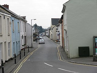
Tywardreath is a small hilltop village on the south coast of Cornwall, England, United Kingdom, about 3 miles (5 km) north west of Fowey. It is located in a sheltered spot overlooking a silted up estuary opposite Par and near the beach of Par Sands. It is on the Saints' Way path.

St Columb Major is a town and civil parish in Cornwall, England, United Kingdom. Often referred to locally as St Columb, it is approximately seven miles (11 km) southwest of Wadebridge and six miles (10 km) east of Newquay The designation Major distinguishes it from the nearby settlement and parish of St Columb Minor on the coast. An electoral ward simply named St Columb exists with a population at the 2011 census of 5,050. The town is named after the 6th-century AD Saint Columba of Cornwall, also known as Columb.

Par is a village and fishing port with a harbour on the south coast of Cornwall, England, United Kingdom. The village is situated in the civil parish of Tywardreath and Par, although West Par and the docks lie in the parish of St Blaise.

Par railway station serves the villages of Par, Tywardreath and St Blazey, Cornwall, England. The station is 281 miles 66 chains from the zero point at London Paddington measured via Box and Plymouth Millbay. It is the junction for the Atlantic Coast Line to Newquay.
St Blazey is a small town in Cornwall, England, United Kingdom.
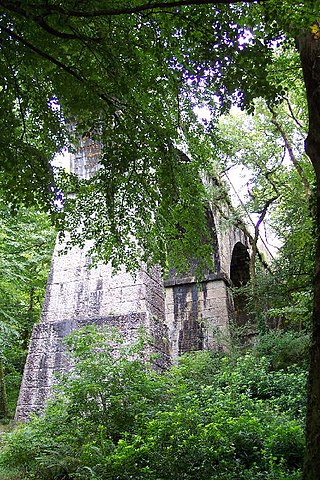
The Luxulyan Valley is the steep sided and thickly wooded valley of the River Par, situated in mid Cornwall, England, UK. It contains a major concentration of early 19th century industrial remains, and was designated as part of a World Heritage Site in 2006.

B roads are numbered routes in Great Britain of lesser importance than A roads. See the article Great Britain road numbering scheme for the rationale behind the numbers allocated.
County Route 9 (CR 9) is a two-lane highway in eastern Orange County, New York, in the United States. The route is 10.0 miles (16.1 km) long, stretching north from an intersection with New York State Route 32 (NY 32) in the hamlet of Central Valley to a junction with NY 218 in the town of Cornwall, just west of the village of Cornwall-on-Hudson. CR 9 passes several historical buildings, such as the Carvey–Gatfield House, Cromwell Manor, the David Sutherland House, and the Sands Ring Homestead Museum.
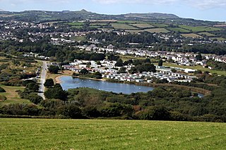
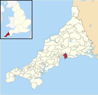
Tywardreath and Par is a civil parish in Cornwall, England, United Kingdom. The 2001 UK census recorded that 3,161 people resided in the parish. This increased to 3,192 at the 2011 census.

Polmear is a hamlet in Cornwall, England, UK. It is located on the A3082 road close to Par Sands and the village of Par. Part is in the civil parish of Fowey and part in Par and Tywardreath parish. The centre of Fowey is some 3 miles (4.8 km) distant, whilst Par railway station is less than 1 mile (1.6 km) away. Polmear used to be known as East Polmear and West Polmear is now known as Charlestown, and has been since Charles Rashleigh built the harbour there.
Little Treviscoe is a village near Treviscoe in Cornwall. It contains about 30 properties. There are numerous abandoned china clay workings in the area surrounding it. In 2013 the village had issues with a cat. It has typical Cornish weather.

Knave-Go-By is a village located on the outskirts of Camborne in the English county of Cornwall in the South West region of the United Kingdom. It is in the TR14 postcode area.
Fowey and Tywardreath was an electoral division of Cornwall in the United Kingdom which returned one member to sit on Cornwall Council between 2013 and 2021. It was abolished at the 2021 local elections, being succeeded by Fowey, Tywardreath and Par.
Par and St Blazey Gate was an electoral division of Cornwall in the United Kingdom which returned one member to sit on Cornwall Council between 2013 and 2021. It was abolished at the 2021 local elections, being succeeded by the divisions of St Blazey and Fowey, Tywardreath and Par.

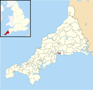
St Blazey is an electoral division of Cornwall in the United Kingdom which returns one member to sit on Cornwall Council. The current Councillor is Pauline Giles, a Conservative. The current division is distinct from the division of the same name used from 2013 to 2021; it is much larger than the former iteration, having absorbed most of the former Par and St Blazey Gate division as part of boundary changes at the 2021 election.

