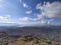
Oruro or Uru Uru is a city in Bolivia with a population of 264,683, about halfway between La Paz and Sucre in the Altiplano, approximately 3,709 meters (12,169 ft) above sea level.
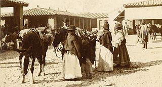
The Aymara or Aimara, people are an indigenous people in the Andes and Altiplano regions of South America. About 2.3 million live in northwest Argentina, Bolivia, Chile, and Peru. Their ancestors lived in the region for many centuries before becoming a subject people of the Inca Empire in the late 15th or early 16th century, and later during the Spanish conquest of Peru in the 16th century. With the Spanish American wars of independence (1810–1825), the Aymaras became subjects of the new nations of Bolivia and Peru. After the War of the Pacific (1879–1883), Chile annexed territory with the Aymara population.

Oruro is a department of Bolivia, with an area of 53,588 km2 (20,690 sq mi). Its capital is the city of Oruro. According to the 2012 census, the Oruro department had a population of 494,178.

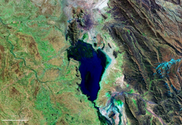
Lake Poopó was a large saline lake in a shallow depression in the Altiplano Mountains in Oruro Department, Bolivia, at an altitude of approximately 3,700 m (12,100 ft). Due to the lake's length and width, it made up the eastern half of Oruro, known as a mining region in southwest Bolivia. The permanent part of the lake body covered approximately 1,000 square kilometres (390 sq mi) and it was the second-largest lake in the country. The lake received most of its water from the Desaguadero River, which flows from Lake Titicaca at the north end of the Altiplano. Since the lake lacked any major outlet and had a mean depth of less than 3 m (10 ft), the surface area differed greatly seasonally.

Ingavi is a province in the La Paz Department in Bolivia. This is where the Battle of Ingavi occurred on November 18, 1841, and where the World Heritage Site of Tiwanaku is situated.

Poopó is a province in the eastern parts of the Bolivian department of Oruro. Its seat is Poopó.

The Desaguadero River, also known as Risawariru or Uchusumain, is a river shared between Bolivia and Peru. It drains Lake Titicaca from the southern part of the river basin, flowing south and draining approximately five percent of the lake's flood waters into Lake Uru Uru and Lake Poopó. Its source in the north is very near the Peruvian border.

Poopó Municipality is the first municipal section of the Poopó Province in the Oruro Department, Bolivia. Its capital is Poopó.
Calacoto or Qala Qutu is the third municipal section of the Pacajes Province in the La Paz Department, Bolivia. Its seat is Calacoto.
Toledo (Oruro) is a small town in Bolivia. Toledo is the administrative seat of Saucarí Province, as well as that of Toledo Municipality. The town lies at an elevation of 3,715 metres (12,188 ft) between Río Laq'a Jawira in the west and Río Vinto Jahuira in the east, both of which drain into Lake Poopó.
Pazña Municipality is a municipality of the Poopó Province in the Oruro Department, Bolivia. Its capital is Pazña.

Jach'a Jawira which downstream is named Japha Jawira is a Bolivian river east of Lake Titicaca in the La Paz Department, Los Andes Province, Batallas Municipality and in the Omasuyos Province, Achacachi Municipality. Its waters flow to Lake Titicaca via the Qiqa Jawira.
The Jach'a Jawira is a river in the La Paz Department of Bolivia, south of Wiñaymarka, the southern branch of Lake Titicaca. It is a tributary of the Desaguadero River.
Qullpa Jawira is a Bolivian river east of Poopó Lake in the Oruro Department, Challapata Province, Challapata Municipality, and in the Santiago de Huari Municipality. It originates near Ch'iyar Jaqhi northeast of Jatun Wila Qullu and flows in a north-eastern direction. South of Wila Qullu it meets the T'ula Pallqa River whose source, the Jach'a Juqhu River, is considered the origin of the Pillku Mayu.
Qullpa Jawira is a Bolivian river west of Poopó Lake and north of Coipasa Lake in the Oruro Department. It flows through the Escara Municipality in the Litoral Province and the Corque Municipality in the Carangas Province.
Jach'a Jawira is a Bolivian river north of Coipasa Lake in the Oruro Department. Coming from the Waylla Marka range northwest of Poopó Lake the river flows in a south-western direction along the village of Belén de Choquecota in the Nor Carangas Province towards the Carangas Province. In the Choquecota Municipality, southwest of Choquecota, it empties into the Barras River which ends in Coipasa Lake.
Jach'a Jawira is a Bolivian river east of Poopó Lake in the Potosí Department, Rafael Bustillo Province, Chuqi Uta Municipality.
Jach'a Jawira is a Bolivian river east of Poopó Lake in the Potosí Department, Rafael Bustillo Province, Uncía Municipality.
Jach'a Jawira which later is named Q'ara Qullu and Waña Jawira is a Bolivian river in the La Paz Department and in the Oruro Department. Its waters flow towards Uru Uru Lake.
The Llallawa Jawira which upstream successively is named Patu Uma, Ch'alla Jawira, Jach'a Qura, Lupipi and Chuqi Phuju is a river in the La Paz Department in Bolivia. It is a left tributary of the Desaguadero River.