Usi County

Last updated
Usi County
우시군
Korean transcription(s)
   Hanja 雩時郡
   McCune–Reischauer Usi-gun
   Revised Romanization Usi-gun
DPRK2006 Chagang-Usi.PNG
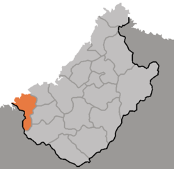
Map of Changang showing the location of Usi
Country North Korea
Province Chagang Province
Administrative divisions 1 ŭp, 1 workers' district, 22 ri
Area
  Total665 km2 (257 sq mi)
Population
 (2008 census)
  Total42,919
  Density65/km2 (170/sq mi)

Usi County is a kun, or county, in westernmost Chagang Province, North Korea. It looks across the Yalu River into the People's Republic of China. Within North Korea, it borders Chosan and Kopung to the east, Songwon to the south, and North Pyongan Province's Pyoktong county to the west. Originally part of Pyoktong, it was made a separate county in 1952 as part of a general reorganization of local government; in 1954, it was transferred from North Pyongan to Chagang.

Contents

There are no railroads in Usi, but it is connected by road to the neighboring districts of Chosan and Pyoktong, and beyond Pyoktong to Sinuiju. In addition, the Yalu is used for transportation. The stretch of the Yalu in Usi is part of the massive "Lake Supung", North Korea's largest reservoir.

The Yalu valley is farmed for rice, while the upland regions produce maize, potatoes, and sesame. There is little manufacturing. The county's Kaha-ri district is known for its medicinal waters.

Administrative divisions

Usi county is divided into one town (ŭp), one worker's district (rodongjagu), and 22 villages (ri). [1]

Chosŏn'gŭl Hancha
Usi-ŭp우시읍
Palŭl-lodongjagu발은노동자구 勞動
Kŭmsŏng-ri금성리
Kŭmyang-ri금양리
Usang-ri우상리
Ujung-ri우중리
Siha-ri시하리
Sisang-ri시상리
P'yŏlha-ri별하리
P'yŏlsang-ri별상리
Kaha-ri가하리
Kajung-ri가중리
Kasang-ri가상리
P'yŏngsang-ri평상리
Taep'yŏng-ri대평리
Sangp'yŏng-ri상평리
Hap'yŏng-ri하평리
Puhŭng-ri부흥리
Pukha-ri북하리
Puksang-ri북상리
Osang-ri오상리
Oha-ri오하리
Ryonghae-ri룡해리
Hachang-ri하창리

See also

Coordinates: 40°40′44″N125°40′08″E / 40.679°N 125.669°E / 40.679; 125.669


Related Research Articles

Uiju County County in North Pyŏngan, North Korea

Ŭiju County is a kun, or county, in North Pyongan Province, North Korea. The county has an area of 420 km², and a population of 110,018.

Kimhyongjik County County in Ryanggang, North Korea

Kimhyŏngjik County is a kun of Ryanggang Province, North Korea. Formerly known as Huch'ang County, it was renamed in 1988 in honour of Kim Hyŏng-jik, the leader of the anti-Japanese liberation movement of Korea.

Kopung County County in Chagang Province, North Korea

Kop'ung County is a kun, or county, in Chagang province, North Korea. Prior to the division of Korea, it was part of Chosan county.

Hwapyong County County in Kwanso, North Korea

Hwapyong County is a kun, or county, in Chagang Province, North Korea. It was incorporated as a new county as part of a general reorganization of local government in December 1952. Previously it had been part of Chasong and Huchang.

Chunggang County County in Chagang Province, North Korea

Chunggang County is a kun, or county, in northern Chagang province, North Korea. It was originally part of Huchang county in Ryanggang, and for that reason older sources still identify it as being part of Huchang. The county seat was originally known as Chunggangjin (중강진), but is now known as Chunggang ŭp. Chunggang looks across the Yalu River at China, and borders Ryanggang province to the south.

Chosan County County in Chagang Province, North Korea

Ch'osan County is a kun, or county, in Chagang province, North Korea. It borders the People's Republic of China to the north.

Chonchon County County in Chagang Province, North Korea

Chŏnch'ŏn County is a kun, or county, in central Chagang province, North Korea. Originally part of Kanggye, it was made a separate county in 1949. The terrain is high and mountainous; the highest point is Sungjoksan, 1984 m above sea level. The Chogyuryong Mountains pass through the eastern part of the county.

Rangrim County County in Chagang Province, North Korea

Rangrim County is a kun, or county, on the eastern flank of Chagang province, North Korea. It was created in 1952 from portions of Changgang and Changjin, as part of a general reorganization of local government. Originally part of South Hamgyong, it was transferred to Chagang province in 1954. It borders Hwapyong and Ryanggang's Kimjongsuk and Kimhyongjik counties to the north, South Hamgyong's Pujon county to the east and Changjin to the south, as well as the counties of Changgang, Songgan, and Ryongnim to the west.

Sijung County County in Chagang Province, North Korea

Sijung County is a kun, or county, in Chagang province, North Korea. It borders Kanggye and Changgang to the east, Manpo to the north and west, and Wiwon to the south. Formerly part of Kanggye, Sijung became a separate county in 1952 as part of a general reorganization of local government.

Songwon County County in Chagang Province, North Korea

Songwŏn County is a kun, or county, in southwestern Chagang province, North Korea. It borders Usi and Kop'ung counties to the north, Tongsin to the east, and Hŭich'ŏn to the south, as well as North P'yŏngan's Tongchang county to the west. Originally part of Chosan, it was established as a separate county in 1949, when Chagang province was created.

Wiwon County County in Chagang Province, North Korea

Wiwŏn County is a kun, or county, in northern Chagang province, North Korea. It stands across the Yalu River from the People's Republic of China. It was originally part of North P'yŏngan province, but was annexed to Chagang in 1954. It borders Manp'o and Sijungto the north, Kanggye and Songgan to the east, Ch'onch'ŏn to the southeast, Kop'ung to the south and west, and Ch'osan to the west.

Tongsin County County in Chagang Province, North Korea

Tongsin County is a kun, or county, in southern Chagang province, North Korea. It borders Ryongrim and Chonchon to the north, the counties of Taehung and Yongwon in South Pyongan to the south and east, and Huichon and Songwon to the west and southwest. Originally part of Huichon, it was created in 1952 as part of a general reorganization of local government.

Changsong County County in North Pyŏngan, North Korea

Changsŏng County is a kun, or county, in northern North Phyŏngan province, North Korea. It is bordered by Pyŏktong to the east, Tongchang and Taegwan to the south, Sakchu to the west; to the north, it faces China across the Yalu (Amrok) River.

Pakchon County County in North Pyŏngan, North Korea

Pakch'ŏn County is a kun, or county, in southern North P'yŏngan province, North Korea. It is bordered to the north by T'aech'ŏn, to the east and southeast by Nyŏngbyŏn, and to the west by Unjŏn counties. To the south, it looks across the Ch'ŏngch'ŏn River at Anju city and Mundŏk county in South P'yŏngan province. In 1952, 4 myŏn of Pakch'ŏn were split off to join Unjŏn county; since then, the county's administrative divisions have been revised in 1954, 1956, 1958, 1978, 1980, and 1982.

Pihyon County County in North Pyŏngan, North Korea

Phihyŏn County is a kun, or county, in northwestern North P'yŏngan province, North Korea. It is bounded to the north by Ŭiju, to the east by Chŏnma, to the south by Yŏmju and Tongrim, and to the west by Ryongchŏn and the large city of Sinŭiju. It was established as a separate county in 1952, and was subsequently reorganized in 1954, 1958, 1961, 1963, 1967 and 1978.

Pyoktong County County in North Pyŏngan, North Korea

Pyŏktong County is a kun, or county, in northern North P'yŏngan province, North Korea. It lies in the valley of the Yalu River, and borders China to the north. Within North Korea, it is bounded by Tongch'ang in the south, Ch'angsŏng in the west, and Usi county in Chagang province to the east. It was separated from Usi in 1952, as part of a nationwide reorganization of local government.

Sakju County County in North Pyŏngan, North Korea

Sakju County is a kun, or county, in northern part of North P'yŏngan province, in North Korea. It lies along the Yalu River bordering the People's Republic of China to the north. Within North Korea, it borders Ch'angsŏng to the east, Ch'ŏnma and Taegwan to the south, and Ŭiju to the west.

Taechon County County in North Pyŏngan, North Korea

T'aechŏn County is a kun, or county, in central North P'yŏngan province, North Korea. It borders Taegwan and Tongch'ang to the north, Unsan and Nyŏngbyŏn to the east, Pakch'ŏn and Unjŏn to the south, and Kusŏng to the west.

Tongchang County County in North Pyŏngan, North Korea

Tongchang County is a kun, or county, in the northeast of the far western North Pyŏngan province, North Korea. It borders Pyŏktong and Chagang's Usi county to the north, Unsan and Songwŏn to the east, Thaechŏn to the south, and Changsŏng and Taegwan to the west.

Sindo County County in North Pyŏngan, North Korea

Sindo County is a kun (county) in the North P'yŏngan province of North Korea. Most of the county consists of Pidansŏm, an island in the estuary of the Yalu River. Sindo was established as a separate county in 1991; previously, it had been part of Ryongch'ŏn, although it had enjoyed a brief existence as a separate county in 1967.