Vineland, Colorado

Last updated

Vineland, Colorado
Vineland, Colorado.JPG
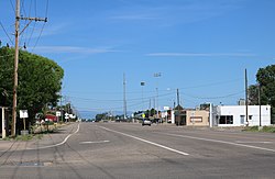
Santa Fe Drive in Vineland, looking west from 36th Lane.
Pueblo County Colorado Incorporated and Unincorporated areas Vineland Highlighted 0881305.svg
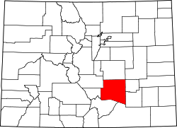
Location of the Vineland CDP in Pueblo County, Colorado.
Usa edcp location map.svg
Red pog.svg
Vineland
Location of the Vineland CDP in the United States.
Coordinates: 38°14′41″N104°27′36″W / 38.24472°N 104.46000°W / 38.24472; -104.46000 (Vineland CDP, Colorado) [1]
Country Flag of the United States.svg  United States
State Flag of Colorado.svg  Colorado
County Pueblo County
Government
[1]
  Type unincorporated community
Area
[2]
  Total0.566 sq mi (1.467 km2)
  Land0.566 sq mi (1.467 km2)
  Water0.000 sq mi (0.000 km2)
Elevation
[1]
4,646 ft (1,416 m)
Population
 (2020) [3]
  Total269
  Density470/sq mi (180/km2)
Time zone UTC-7 (MST)
  Summer (DST) UTC-6 (MDT)
ZIP Code [4]
Pueblo 81006
Area code 719
GNIS feature ID 2583313 [1]

Vineland is a census-designated place (CDP) in and governed by Pueblo County, Colorado, United States. The CDP is a part of the Pueblo, CO Metropolitan Statistical Area. The population of the Vineland CDP was 269 at the United States Census 2020. [3] The Pueblo post office (Zip Code 81006) serves the area. [4]

Contents

Geography

Vineland is just east of the St. Charles River on East US Highway 50 (Business), sometimes called Santa Fe. The area is known in for its family-operated vegetable farms.

The Vineland CDP has an area of 363 acres (1.467 km2), all land. [2]

Demographics

Vineland CDP, Colorado
YearPop.±%
2010 251    
2020 269+7.2%
Source: United States Census Bureau

The United States Census Bureau initially defined the Vineland CDP for the United States Census 2010.

Education

Vineland is served by the Pueblo County School District 70. It is the home of Pueblo County High School, Vineland Elementary School, and Vineland Middle School.

See also

Related Research Articles

<span class="mw-page-title-main">Strasburg, Colorado</span> Census Designated Place in Colorado, United States

Strasburg is an unincorporated town located east of downtown Denver along the I-70 corridor. It is home to Strasburg School District 31-J, and there are several small businesses, medical clinics, and a post office. Strasburg is a census-designated place (CDP) located in and governed by Adams and Arapahoe counties, Colorado, United States. The CDP is a part of the Denver–Aurora–Lakewood, CO Metropolitan Statistical Area. The Strasburg post office has the ZIP Code 80136. At the United States Census 2020, the population of the Strasburg CDP was 3,307.

<span class="mw-page-title-main">Columbine, Colorado</span> Census-designated place in Jefferson and Arapahoe counties in Colorado, United States

Columbine is a census-designated place (CDP) in and governed by Jefferson and Arapahoe counties in Colorado, United States. The CDP is a part of the Denver metropolitan area. Located primarily in Jefferson County, Columbine lies immediately south of Denver. The population of the Columbine CDP was 25,229 at the 2020 census. The community lies in ZIP code 80123.

<span class="mw-page-title-main">Edwards, Colorado</span> Census Designated Place in Colorado, United States

Edwards is an unincorporated town, a post office, and a census-designated place (CDP) located in and governed by Eagle County, Colorado, United States. Edwards is the principal town of the Edwards, CO Micropolitan Statistical Area. The Edwards post office has the ZIP Code 81632. At the United States Census 2020, the population of the Edwards CDP was 11,246. The Edwards Metropolitan District provides services.

<span class="mw-page-title-main">Penrose, Colorado</span> Unincorporated community in Fremont County, Colorado, United States

Penrose is a census-designated place (CDP) and post office located in and governed by Fremont County, Colorado, United States. The CDP is a part of the Cañon City, CO Micropolitan Statistical Area. The Penrose post office has the ZIP Code 81240. At the United States Census 2020, the population of the Penrose CDP was 3,685.

<span class="mw-page-title-main">Applewood, Colorado</span> Census Designated Place in Colorado, United States

Applewood is an unincorporated community and a census-designated place (CDP) located in and governed by Jefferson County, Colorado, United States. The CDP is a part of the Denver–Aurora–Lakewood, CO Metropolitan Statistical Area. The population of the Applewood CDP was 7,833 at the 2020 United States Census. The Golden post office serves the area.

<span class="mw-page-title-main">Evergreen, Colorado</span> Census Designated Place in Colorado, United States

Evergreen is an unincorporated town, a post office, and a census-designated place (CDP) located in and governed by Jefferson County, Colorado, U.S. The CDP is a part of the Denver–Aurora–Lakewood, CO Metropolitan Statistical Area. The Evergreen post office has the ZIP Codes 80439 and 80437. At the 2020 census, the population of the Evergreen CDP was 9,307. The Evergreen Metropolitan District provides services.

<span class="mw-page-title-main">Indian Hills, Colorado</span> Census Designated Place in Colorado, United States

Indian Hills is an unincorporated town, a post office, and a census-designated place (CDP) located in and governed by Jefferson County, Colorado, United States. The CDP is a part of the Denver–Aurora–Lakewood, CO Metropolitan Statistical Area. The Indian Hills post office has the ZIP code 80454. At the United States Census 2020, the population of the Indian Hills CDP was 1,474.

<span class="mw-page-title-main">Pueblo West, Colorado</span> Census-designated place in Pueblo County, Colorado, United States

Pueblo West is a census-designated place (CDP) in and governed by Pueblo County, Colorado, United States. The CDP is part of the Pueblo, CO Metropolitan Statistical Area. The population of the Pueblo West CDP was 33,086 according to the United States Census 2020. The Pueblo West Metropolitan District provides services. The Pueblo post office (Zip Code 81007) serves Pueblo West postal addresses.

<span class="mw-page-title-main">Salt Creek, Colorado</span> Census Designated Place in Colorado, United States

Salt Creek is an unincorporated community and a census-designated place (CDP) located in and governed by Pueblo County, Colorado, United States. The CDP is a part of the Pueblo, CO Metropolitan Statistical Area. The population of the Salt Creek CDP was 507 at the United States Census 2020. The Pueblo post office (Zip Code 81006) serves the area. The community takes its name from Salt Creek, a stream that flows on the community's west side.

<span class="mw-page-title-main">Security-Widefield, Colorado</span> Census Designated Place in Colorado, United States

Security-Widefield is a census-designated place (CDP) comprising the unincorporated communities of Security and Widefield located in and governed by El Paso County, Colorado, United States. The CDP is a part of the Colorado Springs, CO Metropolitan Statistical Area. The population of the Security-Widefield CDP was 38,639 at the United States Census 2020. El Paso County governs the unincorporated communities. Both the Colorado Springs post office and the Fountain post office serve the area.

<span class="mw-page-title-main">West Pleasant View, Colorado</span> Census Designated Place in Colorado, United States

West Pleasant View is an unincorporated community and a census-designated place (CDP) located in and governed by Jefferson County, Colorado, United States. The CDP is a part of the Denver–Aurora–Lakewood, CO Metropolitan Statistical Area. The population of the West Pleasant View CDP was 4,327 at the United States Census 2020. The Pleasant View Metropolitan District provides services. The Golden post office serves the area.

<span class="mw-page-title-main">Cloverleaf, Texas</span> Census-designated place in Texas, United States

Cloverleaf is a census-designated place (CDP) in east central Harris County, Texas, United States. The population was 24,100 at the 2020 census.

<span class="mw-page-title-main">Fairmount, Colorado</span> Census Designated Place in Colorado, United States

Fairmount is an unincorporated community and a census-designated place (CDP) in Jefferson County, Colorado, United States. The CDP is a part of the Denver–Aurora–Lakewood, CO Metropolitan Statistical Area. The population of the Fairmount CDP was 9,324 at the United States Census 2010. ZIP code 80403 applies to addresses in Fairmount.

Colorado Acres is a census-designated place in Webb County, Texas, United States. The population was 296 at the 2010 census. This was a new CDP, formed from parts of the Ranchitos Las Lomas CDP prior to the 2010 census.

Hillside Acres is a census-designated place (CDP) in Webb County, Texas, United States. This was a new CDP, formed from parts of the Ranchitos Las Lomas CDP prior to the 2010 census, with a population of 30.

Las Pilas is a census-designated place (CDP) in Webb County, Texas, United States. This was a new CDP formed from parts of the Ranchitos Las Lomas CDP prior to the 2010 census, with a population of 28.

Los Veteranos I is an unincorporated community and census-designated place (CDP) in Webb County, Texas, United States. This was a new CDP formed from parts of the Ranchitos Las Lomas CDP prior to the 2010 census. The population was 0 at the 2020 census.

Pueblo East is an unincorporated community and census-designated place (CDP) in Webb County, Texas, United States. This was a new CDP formed from parts of the Ranchitos Las Lomas CDP prior to the 2010 census. Despite being a new CDP, the population was listed as zero in 2010.

Valle Verde is an unincorporated community and census-designated place (CDP) in Webb County, Texas, United States.

Pueblo Nuevo is a census-designated place (CDP) in Webb County, Texas, United States.This was a new CDP formed from parts of the Laredo Ranchettes CDP and additional area prior to the 2010 census, with a population of 521.

References

  1. 1 2 3 4 U.S. Geological Survey Geographic Names Information System: Vineland, Colorado
  2. 1 2 "State of Colorado Census Designated Places - BAS20 - Data as of January 1, 2020". United States Census Bureau . Retrieved December 27, 2020.
  3. 1 2 United States Census Bureau. "Vineland CDP, Colorado" . Retrieved April 13, 2023.
  4. 1 2 "Look Up a ZIP Code". United States Postal Service . Retrieved December 27, 2020.