Madagascar is a large island in the Indian Ocean off the eastern coast of Southern Africa, east of Mozambique. It has a total area of 587,040 square kilometres (226,660 sq mi) with 581,540 square kilometres (224,530 sq mi) of land and 5,500 square kilometres (2,100 sq mi) of water. Madagascar is the fourth-largest island and the second-largest island country in the world. The highest point is Maromokotro, in the Tsaratanana Massif region in the north of the island, at 2,876 metres (9,436 ft). The capital Antananarivo is in the Central Highlands near the centre of the island. It has the 25th largest exclusive economic zone of 1,225,259 km2 (473,075 sq mi). Madagascar is 400 kilometres east of mainland Africa.
Paved and unpaved roadways, as well as railways, provide the main forms of transport in Madagascar. Madagascar has approximately 31,640 km (19,660 mi) of paved roads and 836 km of rail lines. In 2010, Madagascar had 432 km (270 mi) of navigable waterways.

Antananarivo, also known by its colonial shorthand form Tana, is the capital and largest city of Madagascar. The administrative area of the city, known as Antananarivo-Renivohitra, is the capital of Analamanga region. The city sits at 1,280 m (4,199 ft) above sea level in the center of the island, the highest national capital by elevation among the island countries. It has been the country's largest population center since at least the 18th century. The presidency, National Assembly, Senate and Supreme Court are located there, as are 21 diplomatic missions and the headquarters of many national and international businesses and NGOs. It has more universities, nightclubs, art venues, and medical services than any city on the island. Several national and local sports teams, including the championship-winning national rugby team, the Makis, are based here.

The Toamasina Province is a former province of Madagascar with an area of 71,911 km². It had a population of 2,855,600 (2004). Its capital was Toamasina, the most important seaport of the country. The province was also known as Tamatave Province.

Toamasina, meaning "like salt" or "salty", unofficially and in French Tamatave, is the capital of the Atsinanana region on the east coast of Madagascar on the Indian Ocean. The city is the chief seaport of the country, situated 215 km (134 mi) northeast of its capital and biggest city Antananarivo. In 2018 Toamasina had a population of 325,857.

Brickaville is a town and commune in Atsinanana Region, Madagascar.

Rail transport in Madagascar is primarily operated by Madarail. There are two unconnected systems having a total length of 855 km (531 mi), as of 2023, all metre gauge, 1,000 mm. The northern railway is concessioned to Madarail. Since April 2022 Madarail has been 100% owned by the Madagascan state. The southern line, Fianarantsoa-Côte-Est railway is a parastatal line.

Analamanga is a region in central Madagascar, containing the capital Antananarivo and its surrounding metropolitan area. The region has an area of 17,488 square kilometres, and had a population of 4,325.226 in 2018.

Moramanga is a city in Madagascar. It is located in the region Alaotra-Mangoro and the Moramanga District. It has a population of 57084 inhabitants (2018).

Alaotra-Mangoro is a region in eastern Madagascar. It borders Sofia Region in north, Analanjirofo in northeast, Atsinanana in east, Vakinankaratra in southwest, Analamanga in west and Betsiboka in northwest. The capital of the region is Ambatondrazaka, and the population was 1,255,514 in 2018. The area of the region is 31,948 km2 (12,335 sq mi).
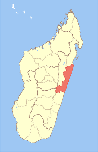
Atsinanana is a coastal region in eastern Madagascar. It borders Analanjirofo region in the north, Alaotra-Mangoro in the west, Vakinankaratra and Amoron'i Mania in the southwest, and Vatovavy in the south. The region contains over 285km of coastline, which includes many beaches and cultural heritage sites.

Districts are second-level administrative divisions of Madagascar below the regions. There are 114 districts in Madagascar. Districts are in their turn divided into communes; while some of the districts in urban areas and offshore islands each consist of only one commune, most of the districts are divided typically into 5–20 communes.
Moramanga District is a district in the Alaotra-Mangoro region in Madagascar. Its capital is Moramanga.

Intense Tropical Cyclone Geralda was a powerful tropical cyclone that caused catastrophic damage in Madagascar in late January 1994, among the strongest to hit the country. It was also the most intense tropical cyclone worldwide in 1994. Cyclone Geralda originated from an area of low pressure over the Indian Ocean on 25 January. Over the following few days, the depression underwent gradual intensification, reaching its peak intensity with ten-minute sustained winds of 205 km/h (127 mph) on 31 January. It eventually made landfall near Toamasina, Madagascar after weakening from its peak intensity, and substantially weakened within hours of moving onshore. By 5 February, Geralda had degenerated into a land depression, and became extratropical three days later. Geralda's remnants dissipated on 12 February.

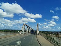
Route nationale 2 (RN2) is a primary highway in Madagascar. The route runs from the capital city of Antananarivo to Toamasina, a city on the eastern coast of the Madagascar.

Andevoranto is a rural municipality in the Brickaville District, Atsinanana Region, Madagascar.
Andekaleka is a town and commune in Madagascar. It belongs to the district of Vohibinany (district), which is a part of Atsinanana Region.
Ambinaninony is a village and rural commune in the Brickaville district in the Atsinanana Region, Madagascar.