South Park is a broad post-World War II development in the south-central area of Houston, Texas, a few miles south of MacGregor Park and directly south of the 610 Loop. According to the 2000 Census, the community has a population of 22,282. 81% of the South Park population is African American, compared to 25% for the city as a whole. Houston's Martin Luther King Boulevard runs through the area. Reflecting its postwar origins, many streets in South Park are named after World War II battle sites and persons. In the 1980s and 1990s crime became a key issue for South Park. Katharine Shilcutt of the Houston Press said "South Park is an overgrown garden these days, its soil only able to be tilled by the most determined or the most desperate. It shows no sign that it will grow again any time in the near future."

Upper Kirby is a commercial district in Houston, Texas, United States. It is named after Kirby Drive, so indirectly takes its name from John Henry Kirby.

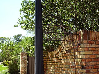
Afton Oaks is a deed-restricted "Inner Loop" upscale residential community of approximately 525 homes in Houston, Texas, United States. Afton Oaks is located inside Interstate 610 near the Galleria and Highland Village. The neighborhood is bounded on the north by Westheimer Road, on the east by Union Pacific railroad tracks, on the south by Interstate 69/U.S. Highway 59, and on the west by Interstate 610.

Rice Military is a neighborhood in Houston, Texas, United States. The Beer Can House is located in Rice Military.

Oak Forest is a large residential community in northwest Houston, Texas, United States. Oak Forest is the third largest group of subdivisions in Harris County.

St. George Place is a neighborhood in Houston, Texas, United States.

Third Ward is an area of Houston, Texas, United States, that evolved from one of the six historic wards of the same name. It is located in the southeast Houston management district.

Rice Epicurean Markets was an American niche grocery store chain based in Southwest Houston, Houston, Texas. There is now just one supermarket left of the chain. Prior to 2012 the company operated five Rice Epicurean Markets, which ranged in size from 25,000 to 42,000 square feet (3,900 m2). At its height, it operated 35 stores. The last Rice Epicurean Market is wholly owned by founding family members.
Sunset Terrace and Montclair Place are two Inner Loop neighborhoods of Harris County, Texas, United States. The two subdivisions are served by the Sunset Terrace/Montclair Civic Association.

Westheimer Road is an arterial east–west road in Houston, Texas, United States. It runs from Bagby Street in Downtown and terminates at the Westpark Tollway on the southern edge of George Bush Park, stretching about 19 miles (31 km) long. The street was named after Michael Louis Westheimer, a German immigrant and flour salesman.

One Park Place is a 501 ft tall apartment building located adjacent to Discovery Green park in downtown Houston, Texas. Completed by The Finger Companies in May 2009, the building has 340 units on 30 floors with a total height of 501 feet (153 m) and 37 floors.
Telephone Road is a street in eastern and southeastern Houston, Texas, United States. The road extends from East McKinney Street to the City of Pearland. A portion of Telephone Road is also designated as Texas State Highway 35.

The Mahatma Gandhi District is an ethnic enclave in Houston, Texas, United States, named after Mahatma Gandhi, consisting predominantly of Indian and Pakistani restaurants and shops and having a large South Asian population. The area is commonly referred to by locals as "Hillcroft," after Hillcroft Avenue, a major thoroughfare which houses much of the Mahatma Gandhi district.
Silverlake is a planned community in unincorporated Brazoria County, Texas, United States, near Pearland and in Greater Houston. The 1,000-acre (400 ha) community has 2,500 single-family houses and 230-acre (93 ha) of supporting commercial usage. It is partially within the extraterritorial jurisdiction of Manvel and partially within the extraterritorial jurisdiction of Pearland.

This article discusses the various cuisines in Houston, Texas.
The Richmond Avenue Entertainment District, commonly known as the Richmond Strip, is an entertainment district along Richmond Avenue in western/southwestern Houston, Texas. It was especially popular in the 1990s, but it later declined as a partygoing destination in favor of other areas of town, such as Washington Avenue. Erin Mulvaney of the Houston Chronicle stated that at its peak, it was "seen as the Houston's answer to Sixth Street, Beale Street and Bourbon Street."
Maggie Rita's Tex-Mex Grill & Bar is a Tex-Mex restaurant in Houston. For several years, Maggie Rita's was a restaurant chain with a license co-owned by Carlos Mencia and Santiago Moreno of Suave Restaurant. In January 2013, Moreno closed the last two locations they owned. Tony Shannard owns the only remaining Maggie Rita's restaurant, which is situated in Houston's JPMorgan Chase Tower.

Molina's Cantina is a Tex-Mex restaurant chain in Houston, Texas. As of 2022, Molina's is the oldest still-operating Tex-Mex restaurant in Houston.

Lower Westheimer is an area in Houston, Texas, United States. It is centered on Westheimer Road, and is considered to be East of Shepherd, and West of Midtown. Several historic neighborhoods are partially or completely located within the area including Montrose and Hyde Park. Lower Wertheimer is known for its hipster culture, nightlife, arts, and food scene.
Rockefeller's is a live music venue located in Houston, Texas.


