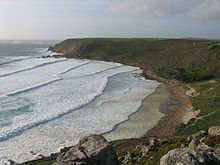
Land's End is a headland and tourist and holiday complex in western Cornwall, England, United Kingdom, on the Penwith peninsula about eight miles (13 km) west-south-west of Penzance at the western end of the A30 road. To the east of it is the English Channel, and to the west the Celtic Sea.

Sennen is a coastal civil parish and a village in Cornwall, England, United Kingdom. Sennen village is situated approximately eight miles (13 km) west-southwest of Penzance.

Porthcurno is a small village covering a small valley and beach on the south coast of Cornwall, England in the United Kingdom. It is the main settlement in a civil and an ecclesiastical parish, both named St Levan, which comprise Porthcurno, diminutive St Levan itself, Trethewey and Treen.

Mount's Bay is a bay on the English Channel coast of Cornwall, England, stretching from the Lizard Point to Gwennap Head. In the north of the bay, near Marazion, is St Michael's Mount; the origin of name of the bay. In summer, it is a generally benign natural harbour. However, in winter, onshore gales present maritime risks, particularly for sailing ships. There are more than 150 known wrecks from the nineteenth century in the area. The eastern side of the bay centred around Marazion and St Michael's Mount was designated as a Marine Conservation Zone in January 2016.

Fistral Beach is in Fistral Bay on the north coast of Cornwall, England, United Kingdom. It is situated half-a-mile west of Newquay at grid reference SW 797 620.

Rock is a coastal fishing village in Cornwall, England, United Kingdom. It is opposite Padstow on the north-east bank of the River Camel estuary. The village is in the civil parish of St Minver Lowlands about 4 miles (6.4 km) north-west of Wadebridge.
Trebetherick is a village on the north coast of Cornwall. It is situated on the east side of the River Camel estuary approximately six miles (10 km) north of Wadebridge and half a mile south of Polzeath.

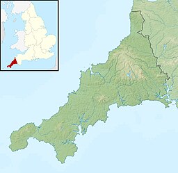
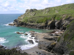
Treen is a small village in the parish of St Levan, in the far west of Cornwall, England, United Kingdom. It is about 3 miles (4.8 km) inland from Land's End on a short unclassified spur road from the B3315. Treen overlooks the Penberth Valley and sits about 1 kilometre (0.62 mi) inland from Treryn Dinas, an Iron Age promontory fort, or cliff castle, with five lines of fortification. On the headland is the Logan Rock and to the west is Pedn Vounder tidal beach, which is popular with naturists. Treen Cliff is to either side of Treryn Dinas. The village has a popular pub, The Logan Rock Inn, a village shop, cafe and campsite with views to both Logan Rock and nearby Porthcurno.

Gwithian is a coastal village and former civil parish, now in the parish of Gwinear-Gwithian, in the Cornwall district, in west Cornwall, England. It is three miles (5 km) north-east of Hayle and four miles (6.5 km) east of St Ives, Cornwall across St Ives Bay. In 1931 the parish had a population of 634. On 1 April 1934 the parish was abolished to form "Gwinear Gwithian".

St Levan is a civil parish in Cornwall, England, United Kingdom. The parish is rural with a number of hamlets of varying size with Porthcurno probably being the best known. Hewn out of the cliff at Minack Point and overlooking the sea to the Logan Rock is the open-air Minack Theatre, the inspiration of Rowena Cade in the early 1930s.
Prussia Cove, formerly called King's Cove, is a small private estate on the coast of Mount's Bay and to the east of Cudden Point, west Cornwall, England, United Kingdom. Part of the area is designated as a Site of Special Scientific Interest (SSSI), a Geological Conservation Review site and is in an Area of Outstanding Natural Beauty (AONB). It consists of four small coves and several cottages and houses. The names of the coves from west to east are Piskies, Bessy's, King's and Coule's. The area is accessible by foot from the South West Coast Path The cove is known for the 18th-century ship-wrecker and smuggler John Carter, also known as the "King of Prussia".

Sennen Cove is a small coastal village in the parish of Sennen in Cornwall, England, United Kingdom. According to the Penwith District Council, the population of this settlement was estimated at 180 persons in 2000. The South West Coast Path passes through Sennen Cove.

Nanjizal, also known as Mill Bay, is a beach and cove in the civil parish of St Levan, Cornwall, on the south-western coast of Great Britain. Situated one mile to the south-east of Land's End, Nanjizal has no direct access via road, and is usually reached via the South West Coast Path from Land's End in the north, or from Porthgwarra to the south. Nanjizal is also a noted bird watching location.

Gurnard's Head is a prominent headland on the north coast of the Penwith peninsula in Cornwall, England. The name is supposed to reflect that the rocky peninsula resembles the head of the gurnard fish.

Gwennap Head is a headland on the south coast of the Penwith peninsula, Cornwall, United Kingdom. It is within the parish of St Levan and approximately 4 miles (6.4 km) south of Land's End, and less than 1 mile (1.6 km) north-west of Porthgwarra, the nearest village. The area of Gwennap Head is designated as part of the Penwith Heritage Coast and also designated as part of the Cornwall Area of Outstanding Natural Beauty. The South West Coast Path closely follows the coastline around the headland.

Pedn Vounder is a tidal beach on the south coast of the Penwith peninsula in Cornwall, England. It is immediately to the west of the Logan Rock headland, below Treen Cliff. The name is from the Cornish 'pen' and 'an vounder'.

Mawgan Porth is a beach and small settlement in north Cornwall, England. It is north of Watergate Bay, approximately four miles (6 km) north of Newquay, on the Atlantic Ocean coast.

Porth Hellick is a tidal inlet on the south coast of St Mary’s, the largest island in the Isles of Scilly.
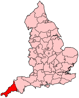
The following outline is provided as an overview of and topical guide to Cornwall: Cornwall – ceremonial county and unitary authority area of England within the United Kingdom. Cornwall is a peninsula bordered to the north and west by the Celtic Sea, to the south by the English Channel, and to the east by the county of Devon, over the River Tamar. Cornwall is also a royal duchy of the United Kingdom. It has an estimated population of half a million and it has its own distinctive history and culture.
Geotomus punctulatus, also known as the Cornish shieldbug, is a species of burrowing bug in the family Cydnidae, found in Asia and Europe.