Related Research Articles

San Francisquito Canyon is a canyon created through erosion of the Sierra Pelona Mountains by the San Francisquito Creek, in Los Angeles County, Southern California.

Elizabeth Lake is a natural sag pond that lies directly on the San Andreas Fault in the northern Sierra Pelona Mountains, in northwestern Los Angeles County, southern California.

The Sierra Pelona, also known as the Sierra Pelona Ridge or the Sierra Pelona Mountains, is a mountain ridge in the Transverse Ranges in Southern California. Located in northwest Los Angeles County, the ridge is bordered on the north by the San Andreas fault and lies within and is surrounded by the Angeles National Forest.
Warner's Ranch, near Warner Springs, California, was notable as a way station for large numbers of emigrants on the Southern Emigrant Trail from 1849 to 1861, as it was a stop on both the Gila River Trail and the Butterfield Overland Mail stagecoach line (1859-1861). It was also operated as a pioneering cattle ranch.

Green Valley is a census-designated place in the Sierra Pelona Mountains, in Los Angeles County, California. It lies at an elevation of 2936 feet. The population was 1,027 at the 2010 census.
Rancho Rincon de San Francisquito was a 8,418-acre (34.07 km2) Mexican land grant in present-day Santa Clara County, California given in 1841 by Governor Juan Alvarado to José Peña. The name means "corner or bend of the San Francisquito" referring to San Francisquito Creek. The grant extended along Matadero Creek to the hills and included the southern part of present-day Palo Alto and the southern part of the Stanford University campus.
Rancho San Francisquito was a 1,471-acre (5.95 km2) Mexican land grant in present-day Santa Clara County, California given in 1839 by Governor Juan Alvarado to Antonio Buelna. The grant was located on the southwest side of San Francisquito Creek and encompasses present-day western Menlo Park and the northern part of the Stanford University campus.
Rancho Los Coches was a 8,794-acre (35.59 km2) Mexican land grant in present-day Monterey County, California given in 1841 by Governor Juan Alvarado to María Josefa Soberanes. The name means "the pigs". The grant was south of Soledad and extended along the Arroyo Seco.

Rancho San Luis Gonzaga was a 48,821-acre (197.57 km2) Mexican land grant in the Diablo Range, in present-day Santa Clara County and Merced County, California given in 1843 by Governor Manuel Micheltorena to Juan Carlos Pacheco and José Maria Mejía. The grant was bounded by Francisco Pérez Pachecos Rancho Ausaymas y San Felipe on the west, the San Joaquin River and San Joaquin Valley on the east, and Los Baños Creek on the south.
Rancho Little Temecula was a 2,233-acre (9.04 km2) Mexican land grant in present-day Riverside County, California given in 1845 by Governor Pío Pico to Pablo Apis. The grant was one of the few held by indigenous people. The grant is south of present-day Temecula and is bordered on the north by Temecula Creek. At the time of the US patent, Rancho Little Temecula was a part of San Diego County. Riverside County was created by the California Legislature in 1893 by taking land from both San Bernardino and San Diego Counties.

Rancho Temescal was a farming outpost of Mission San Luis Rey de Francia, one of the 21 Franciscan missions established in California by Spain during the late 18th and early 19th centuries. The Mission was located on the coast where Oceanside, California, is today. The Rancho was settled in 1819 by Leandro Serrano, and became the first non-native settlement within the boundaries of what would become Riverside County, California.
The Butterfield Overland Mail in California was created by the United States Congress on March 3, 1857, and operated until June 30, 1861. Subsequently, other stage lines operated along the Butterfield Overland Mail in route in Alta California until the Southern Pacific Railroad arrived in Yuma, Arizona in 1877.

The Lyons Station Stagecoach Stop,, was a tavern and stagecoach stop near the southwest corner of Newhall Avenue and Sierra Highway, by Eternal Valley Cemetery. The site is located in the present day Newhall section of Santa Clarita, in Los Angeles County, California.
El Camino Viejo a Los Ángeles, also known as El Camino Viejo and the Old Los Angeles Trail, was the oldest north-south trail in the interior of Spanish colonial Las Californias (1769–1822) and Mexican Alta California (1822–1848), present day California. It became a well established inland route, and an alternative to the coastal El Camino Real trail used since the 1770s in the period.

San Francisquito Creek, in Los Angeles County, is a tributary stream of the Santa Clara River. It drains the south facing slopes of the Sierra Pelona Mountains of the San Gabriel Mountains within the Transverse Range of California, United States.
San Francisquito Pass is a mountain pass in the Sierra Pelona Mountains, located northeast of Green Valley and Santa Clarita, in northern Los Angeles County, California.
Mud Spring, formerly called Aquaje Lodoso, is a spring and historic site in the western Antelope Valley, within northern Los Angeles County, southern California.
King's Station, also known as Moore's and Hollandsville, was a stagecoach station of the Butterfield Overland Mail 1st Division between 1858 and 1861 in southern California.
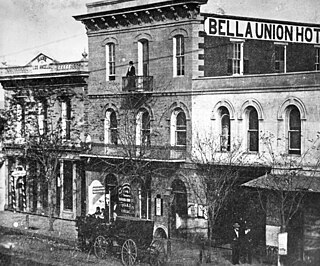
The Bella Union Hotel in Los Angeles, California, constructed in 1835, is California Historical Landmark No. 656. It was effectively the last capitol building of Mexican California under Governor Pio Pico, in 1845–47, and was a center of social and political life for decades. The hotel was located at N. Main Street, on the east side, a few doors north of Commercial Street, which then ran east–west between Arcadia and Temple. The hotel was later known as the Clarendon and then as the St. Charles.
Lone Willow Station was a former settlement in Merced County, California, located near present-day Los Banos.
References
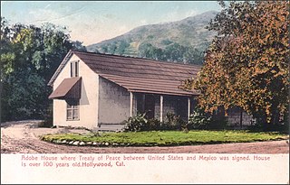
- 1 2 3 4 Santa Clara Valley History Association: "Major Gordon's Station" (Widow Smith's Station) history
- ↑ List of Butterfield Overland Mail Stations, from New York Times, October 14 1858, "Itinerary of the Route"
- ↑ Mildred Brooke Hoover, Hero Eugene Rensch, Ethel Grace Rensch, 3rd Edition revised by William N. Abeloe, Historic Spots in California, 3rd Ed., Stanford University Press, Stanford, 1966, p.168
- ↑ Harris Newmark, "Sixty Years in Southern California, 1853-1913", The Knickerbocker Press, New York, 1916, p. 195
- ↑ Notes of a Trip to Los Angeles No. 1, Daily Alta California, Volume 12, Number 3888, 5 October 1860 — Page 1
- ↑ SCVH: HABS Major Gordon's Station description page
- ↑ Major Gordon's Station, San Francisquito Canyon; 1936 Photos and HABS Renderings, from www.scvhistory.com
- ↑ Mildred Brooke Hoover, Hero Eugene Rensch, Ethel Grace Rensch, 3rd Edition revised by William N. Abeloe, Historic Spots in California, 3rd Ed., Stanford University Press, Stanford, 1966, p.168