
Death Valley National Park is a national park of the United States that straddles the California–Nevada border, east of the Sierra Nevada. The park boundaries include Death Valley, the northern section of Panamint Valley, the southern section of Eureka Valley and most of Saline Valley.

Death Valley is a desert valley in Eastern California, in the northern Mojave Desert, bordering the Great Basin Desert. It is thought to be the hottest place on Earth during summer.

Inyo County is a county in the eastern central part of the U.S. state of California, located between the Sierra Nevada and the state of Nevada. In the 2020 census, the population was 19,016. The county seat is Independence. Inyo County is on the east side of the Sierra Nevada and southeast of Yosemite National Park in Central California. It contains the Owens River Valley; it is flanked to the west by the Sierra Nevada and to the east by the White Mountains and the Inyo Mountains. With an area of 10,192 square miles (26,400 km2), Inyo is the second-largest county by area in California, after San Bernardino County. Almost half of that area is within Death Valley National Park. However, with a population density of 1.8 people per square mile, it also has the second-lowest population density in California, after Alpine County.

Mount Whitney is the highest mountain in the contiguous United States, with an elevation of 14,505 feet (4,421 m). It is in East–Central California, in the Sierra Nevada, on the boundary between California's Inyo and Tulare counties, and 84.6 miles (136.2 km) west-northwest of North America's lowest topographic point, Badwater Basin in Death Valley National Park, at 282 ft (86 m) below sea level. The mountain's west slope is in Sequoia National Park and the summit is the southern terminus of the John Muir Trail, which runs 211.9 mi (341.0 km) from Happy Isles in Yosemite Valley. The eastern slopes are in Inyo National Forest in Inyo County. Mount Whitney is ranked 18th by topographic isolation.

Stovepipe Wells is a way-station in the northern part of Death Valley, in unincorporated Inyo County, California.

The Panamint Range is a short rugged fault-block mountain range in the northern Mojave Desert, within Death Valley National Park in Inyo County, eastern California. A small part of the southern end of the range is in San Bernardino County. Dr. Darwin French is credited as applying the term Panamint in 1860 during his search for the fabled Gunsight Lode.
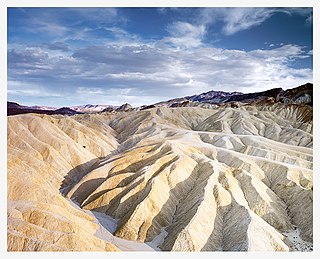
Places of interest in the Death Valley area are mostly located within Death Valley National Park in eastern California.

Telescope Peak is the highest point within Death Valley National Park, in the U.S. state of California. It is also the highest point of the Panamint Range, and lies in Inyo County. From atop this desert mountain one can see for over one hundred miles in many directions, including west to Mount Whitney, and east to Charleston Peak. The mountain was named for the great distance visible from the summit.

The Whitney Classic is an 136-mile-long (219 km) endurance mountain bike race that is held in late September or October every year. The ride runs from the Badwater Basin in Death Valley to Whitney Portal. Badwater, at 279 feet (85 m) below sea level, is the lowest place in the North America and Whitney Portal at 8,360 feet (2,550 m) is the trailhead that leads to Mount Whitney, the highest peak in the contiguous United States with an elevation of 14,505 feet (4,421 m).

Dante's View is a viewpoint terrace at 1,669 m (5,476 ft) height, on the north side of Coffin Peak, along the crest of the Black Mountains, overlooking Death Valley. Dante's View is about 25 km (16 mi) south of Furnace Creek in Death Valley National Park.

Arizona is a landlocked state situated in the southwestern region of the United States of America. It has a vast and diverse geography famous for its deep canyons, high- and low-elevation deserts, numerous natural rock formations, and volcanic mountain ranges. Arizona shares land borders with Utah to the north, the Mexican state of Sonora to the south, New Mexico to the east, and Nevada to the northwest, as well as water borders with California and the Mexican state of Baja California to the southwest along the Colorado River. Arizona is also one of the Four Corners states and is diagonally adjacent to Colorado.
The Sylvania Mountains Wilderness is a federally designated wilderness area located 30 miles (48 km) east of Bishop in the state of California. The wilderness is 18,677acres in size and is managed by the Bureau of Land Management (BLM). The California Desert Protection Act of 1994 created the Sylvania Mountains Wilderness and was added to the National Wilderness Preservation System. The wilderness is bordered by Nevada stateline on the east, Piper Mountain Wilderness on the west and Death Valley National Park to the south.

The Titan is a 6,112-foot-elevation (1,863-meter) pillar in Grand County, Utah, United States.

Sentinel Peak is a 9,634-foot-elevation (2,936-meter) summit in Inyo County, California, United States. It is located near Panamint City, California. Sentinel Peak is the sixth-highest mountain of the Panamint Range, and it is set within Death Valley National Park and the Mojave Desert. Precipitation runoff from this mountain's east slope drains to Death Valley via Johnson Canyon, whereas the west slope drains to Panamint Valley via Happy and Surprise canyons.

Inclined Temple is a remote 7,150-foot elevation summit located in Zion National Park, in Washington County of southwest Utah, United States.
Saint Mary Peak is a 9,351-foot elevation (2,850 m) mountain summit located in Ravalli County, Montana.
Northgate Peaks are two summits in Washington County, Utah, United States.

White Top Mountain is a 7,607-foot-elevation (2,319-meter) summit in Inyo County, California, United States.

Rogers Peak is a 9,991-foot-elevation (3,045-meter) summit in Inyo County, California, United States.

Edgar Peak is a 7,162-foot-elevation (2,183-meter) summit in San Bernardino County, California, United States.


